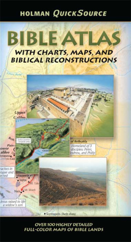
Holman QuickSource Bible Atlas
2005 by Holman Bible Publishers
Nashville, Tennnessee
All rights reserved
Maps 2000 by Holman Bible Publishers
Nashville, Tennessee
All rights reserved
ISBN 978-0-8054-9564-5
Dewey Decimal Classification: 220.9
Subject Heading: BIBLEATLASES
The Holman Editorial Staff gratefully acknowledges the contribution of Dr. James McLemore and the staff of Biblical Illustrator (G. B. Howell, current editor) for consultation on Holman QuickSource Bible Atlas with Charts and Biblical Reconstructions. Many of the visual resources contained herein are from the archives of the Biblical Illustrator. For additional information about the Biblical Illustrator go to the following Web address: www.lifeway.com and then do a search on Biblical Illustrator.
The Agricultural Year Thomas V. Brisco.
Used by permission.
Unless otherwise noted, Scripture passages are taken from the Holman Christian Standard Bible (HCSB), copyright 2001 by Holman Bible Publishers. All rights reserved. Unless otherwise noted Old Testament Scripture passages are taken from the New International Version (NIV), copyright 1973, 1978, 1984 by the International Bible Society.
1 2 3 4 5 6 7 8 9 10 15 14 13 12 11 10
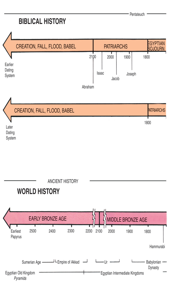
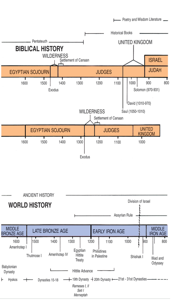
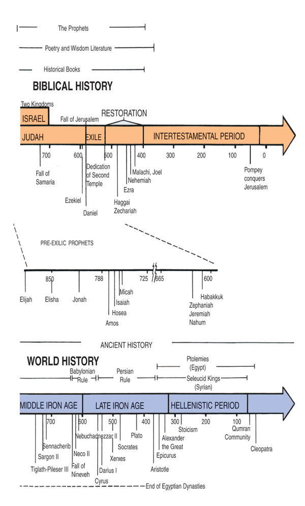
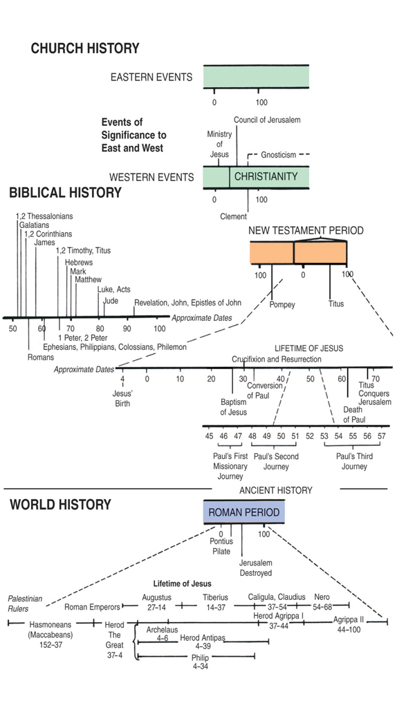
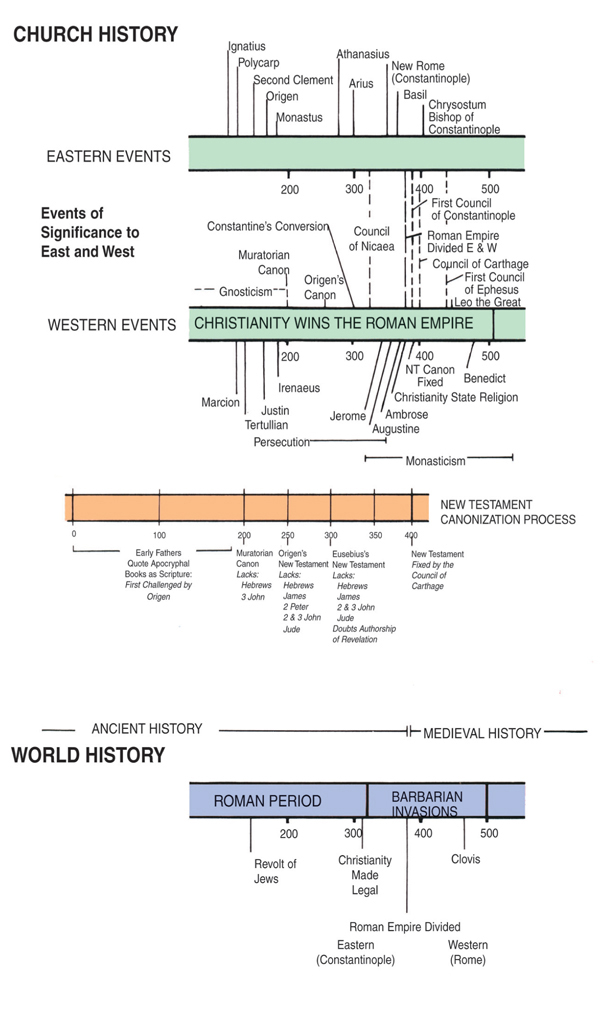
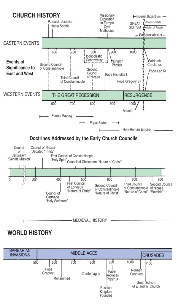
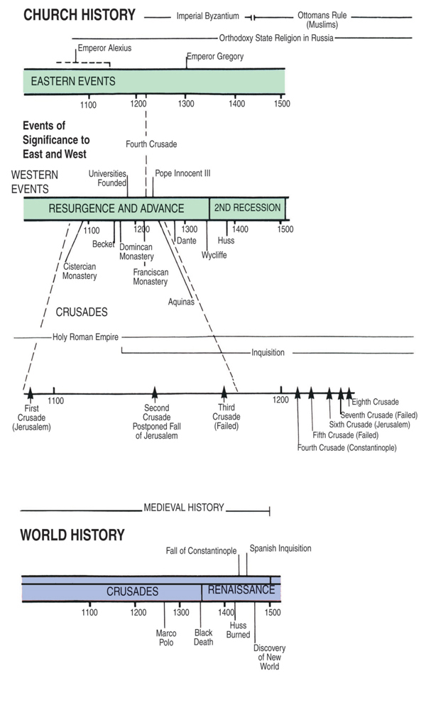
TIME LINE
FOREWORD
The Holman QuickSource Bible Atlas has two divisions.
GEOGRAPHY OF THE BIBLE LANDS
The first division focuses on the narrow strip of land that is broadly called Palestine, Israel, or the Holy Land. This is the land God promised to Abraham and that came fully under Israel's control during the time of David. This part of the atlas looks at the major regions of Palestine, giving attention to the geographical and climatological features of each region. This section of the QuickSource Bible Atlas was written by Paul H. Wright, director of Jerusalem University College Institute of Holy Land Studies. Dr. Wright is a graduate of Trinity Evangelical Divinity School (M.A.), Institute of Holy Land Studies (M.A.), and Hebrew Union College (Ph.D.).
MAPS OF BIBLE LANDS
The second division of the QuickSource Bible Atlas begins with Noah, follows the Bible's story line from Genesis to Revelation, and contains information on the expansion of Christianity to the third century. This division is arranged in sections according to the major divisions of biblical history. Each section includes maps, charts, and biblical reconstructions that illuminate that epoch of history. The QuickSource Bible Atlas ends with charts that summarize the development of the biblical canon and explains weights and measures of the Bible.
INTRODUCTION
Long ago God spoke to the fathers by the prophets at different times and in different ways. In these last days, He has spoken to us by His Son (Heb. 1:1-2). The writer of the book of Hebrews reminds us how God revealed Himself to people in the past.
As creator of the universe, God stands outside of time and space. He nevertheless chose to enter a real flesh-and-blood world in order to create, and then redeem, mankind. For hundreds of years God communicated His words and will to an eager, yet usually recalcitrant, people who made their homes in the lands hugging the southeastern shore of the Mediterranean Sea. Then, in what the Apostle Paul called the completion of time (Gal. 4:4), God Himself bent down to enter the human race, choosing to dirty His hands and feet in a small, noisy, and very needy corner of the Roman Empire called Galilee (cp. Phil. 2:5-8).
Unlike sacred books of the world's other great religions, the Bible is full of stories of real people living in real places. God's decision to communicate eternal truths through fallible human beings, to wrap His message around mankind's experiences with rock and soil and water, is both mind-boggling and humbling. It also suggests that a full understanding of God's revelation cannot be gained without an appreciation of the physical context in which that revelation was given.
1 THE ANCIENT NEAR EAST
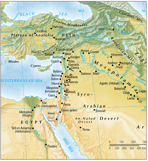
The writers of the Bible knew well the land in which God chose to reveal Himself, for it was their home. They were intimately familiar with the rugged terrain of Judah, with cold winter rain and scorching desert heat, and they had experienced the relief offered by a small spring of water or the shelter of a crevasse in a mighty rock. They knew what it meant for the hills surrounding their city or village to be filled with enemy troops or to lie down at night secure after a bountiful harvest. Time and again the Bible's historians, prophets, and poets used such information to enliven the divine message they had to tell. Geographical information fills the biblical text, and the biblical authors assumed that their readers knew even more. The land of the Bible has rightly been termed the playing board of biblical history (James M. Monson, Regions on the Run, Rockford, IL: Biblical Backgrounds, 1998, p. 3). It is difficult at best to understand fully the instructions (the Bible) without the board (the land) on which the events of the Bible were played out.
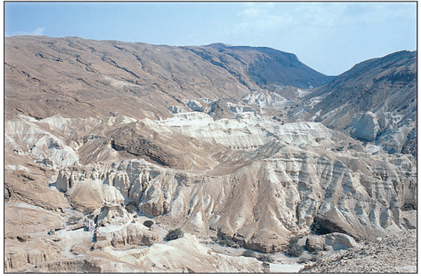
The rugged terrain characteristic of the wilderness of Judah.
Many people journey to the lands of the Bible with the hope of walking where Jesus walked. In spite of the established pilgrimage spots in the Holy Land, however, it is just not possible to say with certainty that Jesus stood on spot X when he healed such-and-such a person or delivered such-and-such a teaching. On the other hand, the location of many biblical cities, hills, valleys, and the like are known, and by carefully studying the geographical settings of the Bible, the serious reader can enter more deeply into its world. It becomes possible to follow Joshua's army into the hill country of Canaan after laying waste to Jericho. One can climb to the crest of the hill on which David's Jerusalem stood and still experience the energy of the Songs of Ascent (Pss. 121-134). Jesus must have often gazed over the Sea of Galilee in the early mornings from the hills above Capernaum (cp. Mark 1:35); doing so today helps the serious Bible reader appreciate Jesus' call to ministry and one's own place in the kingdom of God.
Next page
