ZONDERVAN
Zondervan Essential Atlas of the Bible
Copyright 2013 by Carl G. Rasmussen
Requests for information should be addressed to:
Zondervan, Grand Rapids, Michigan 49530
Library of Congress Cataloging-in-Publication Data
Rasmussen, Carl.
Zondervans essential atlas of the Bible / Carl G. Rasmussen.
p. cm.
Includes bibliographical references and index.
ISBN 978-0-310-31857-6 (pbk.)
1. BibleGeographyMaps. 2. BibleHistory of Biblical eventsMaps. I. Title.
G2230.R33 2014
220.9'10223dc23 2012589773
All Scripture quotations, unless otherwise indicated, are taken from The Holy Bible, New International Version, NIV. Copyright 1973, 1978, 1984, 2011 by Biblica, Inc. Used by permission. All rights reserved worldwide.
Maps created by International Mapping. Copyright 2010 by Zondervan. All rights reserved.
Any Internet addresses (websites, blogs, etc.) and telephone numbers in this book are offered as a resource. They are not intended in any way to be or imply an endorsement by Zondervan, nor does Zondervan vouch for the content of these sites and numbers for the life of this book.
All rights reserved. No part of this publication may be reproduced, stored in a retrieval system, or transmitted in any form or by any meanselectronic, mechanical, photocopy, recording, or any otherexcept for brief quotations in printed reviews, without the prior permission of the publisher.
Cover design: www.wdesigncompany.com
Cover photography: Ben Greenhoe/Zondervan; Michael Melford/Getty Images; www.holylandphotos.org; Slow Images/Getty Images
CONTENTS
T his volume is an adaption of the more complete Zondervan Atlas of the Bible. It begins with a concise , which introduces to the reader the lands of the Bible, including Israel/Jordan, Egypt, Syria and Lebanon, and Mesopotamia. Helpful maps, charts, and pictures illustrate the topic discussedtopography, regions, weather, roads, and so on.
The .
This atlas is intended for readers of the Bible who want concise information close by as they are reading the biblical text. It is ideal for use by Bible study groups, adult Bible classes, and travelers to the Middle East, and it will serve well as an auxiliary textbook for college, university, and seminary classes.
I wish to thank acquisitions editor David Frees, who helped initiate this project, and acquisitions editor Madison Trammel, who has seen it through to completion. As with the Zondervan Atlas of the Bible, Kim Tanners valuable expertise shows through in the development and presentation of maps, graphics, and pictures. Mark Connally has graciously allowed the use of some of his beautiful images in this volume. Mark Sheeres and his team have developed a layout that has made the volume a pleasure to view and use. I was greatly involved in revising the text of the larger work for this volume, but I would especially like to thank Verlyn Verbrugge, whose wisdom and skill brought this process to a successful conclusion. In addition, I would like to thank Stanley Gundry and Paul Engle for their encouraging support through the years.
Finally I would like to thank my wife, Mary, whose love, companionship, and encouragement over the years has been a blessing to me and to all those with whom she comes in contact.
Carl G. Rasmussen
AD Anno Domini, In the year of our Lord (i.e., after the birth of Christ)
ANET J. B. Pritchard, ed., Ancient Near Eastern Texts Relating to the Old Testament. Third edition. Princeton: Princeton University Press, 1969.
BC Before Christ
c., ca. circa, about
ch., chs. chapter(s)
e.g. for example
EB Early Bronze Age
ed., eds. editor(s)
esp. especially
et al. and others
etc. et cetera, and so on
F Fahrenheit
ft. foot, feet
H. Horbat
Heb. Hebrew
in. inch(es)
Jos.Antiq. Josephus: The Antiquities of the Jews
Jos.Apion Josephus: Against Apion
Jos.Life Josephus: Life
Jos.War Josephus: The Jewish War
Kh. Khirbet
LB Late Bronze Age
MB Middle Bronze Age
mi. mile(s)
Mt(s). Mountain(s)
N. Nahr/Nahal
NASB New American Standard Bible
NIV New International Version
NT New Testament
OT Old Testament
p., pp. page(s)
par., pars. paragraph(s)
R. River
sq. square
T. Tell (Arabic)/Tel (Hebrew)
v., vv. verse(s)
W. Wadi
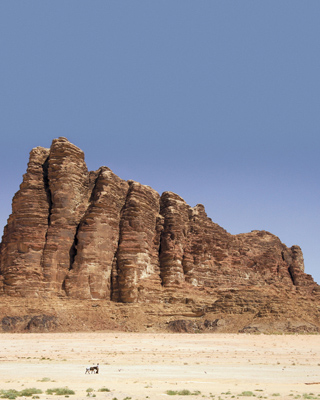
T he stage on which the major events of Old Testament history took place includes all the major countries shown on . This large land mass is bounded on the west by the Nile River and the Mediterranean Sea, on the north by the Amanus and Ararat Mountains, and on the east by the Zagros Mountains and the Persian Gulf. To the south, the Nafud Desert and the southern tip of Sinai form a rather loose boundary.
Much of the Middle East is desert. Large portions of modern-day Syria, Iraq, Jordan, and Saudi Arabia include desert wastes such as the Syrian Desert, the Nafud, the Arabian Desert, the Ruba al-Khali, Negev, Sinai, and Egypt. The seas and gulfs that help outline the Middle East have influenced life in the area. The most important of these is the Mediterranean Sea, which offers life-giving rains to most of the region. Much of what has occurred in the Middle East can be summed up as a struggle between the influences of the desert and the Mediterranean Sea over against the people who have lived there.
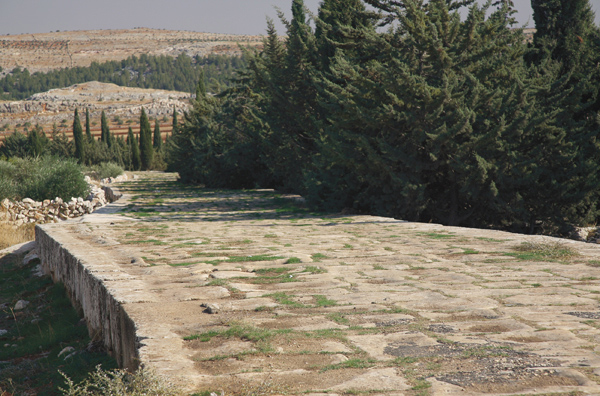
Roman road in Syria
The first section of this book outlines briefly some of the significant challenges of this part of the worldgeography, climate, roads, trade routes, food supply, and the like. It is easy to determine where the majority of people have lived in the Near East by highlighting on a map (see ) the areas watered by the Nile, the Tigris, and the Euphrates, as well as those regions that receive over twelve inches of rainfall annually. This area is roughly the shape of a crescent, with one point in the Nile River and the other in the Persian Gulf. It is aptly named the Fertile Crescent.
THE MIDDLE EAST TODAY
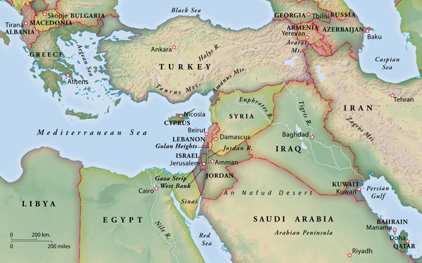
THE ANCIENT NEAR EAST

Terrain
A t the southeastern end of the Mediterranean Sea, we can distinguish five major longitudinal zones. As one moves from west to east they are: the coastal plain, the central mountain range, the rift valley, the Transjordanian mountains, and the eastern desert.
(1) The coastal plain stretches approximately 120 miles along the Mediterranean coast from Rosh HaNiqra south to Gaza. It receives 25 to 16 inches of rain per year, the northern sections receiving more rain than the southern. A few powerful springs provided water, but more commonly the inhabitants used wells to tap the water table. The coastal plain consists mainly of low, rolling hills covered with fertile alluvial soils. Grain crops flourished in the winter and spring months, while flocks grazed there during the remainder of the year.
Next page


