First published in Great Britain in 2015 by
PEN & SWORD MILITARY
An imprint of
Pen & Sword Books Ltd
47 Church Street
Barnsley
South Yorkshire
S70 2AS
Copyright Jon Diamond, 2015
ISBN: 978-1-47384-558-9
EPUB ISBN: 978-1-47385-447-5
PRC ISBN: 978-1-47385-459-8
The right of Jon Diamond to be identified as author of this work has been asserted by him in
accordance with the Copyright, Designs and Patents Act 1988.
A CIP catalogue record for this book is available from the British Library.
All rights reserved. No part of this book may be reproduced or transmitted in any form or by any
means, electronic or mechanical including photocopying, recording or by any information storage
and retrieval system, without permission from the Publisher in writing.
Typeset by Concept, Huddersfield, West Yorkshire HD4 5JL.
Printed and bound in England by CPI Group (UK) Ltd, Croydon CR0 4YY.
Pen & Sword Books Ltd incorporates the imprints of Pen & Sword Archaeology, Atlas, Aviation,
Battleground, Discovery, Family History, History, Maritime, Military, Naval, Politics, Railways, Select,
Social History, Transport, True Crime, and Claymore Press, Frontline Books, Leo Cooper,
Praetorian Press, Remember When, Seaforth Publishing and Wharncliffe.
For a complete list of Pen & Sword titles please contact
PEN & SWORD BOOKS LIMITED
47 Church Street, Barnsley, South Yorkshire, S70 2AS, England
E-mail:
Website: www.pen-and-sword.co.uk
Contents
Introduction
I n 1941, Malaya was comprised of the Straits Settlements of Singapore, Malacca and Penang, which all formed a British colony under Governor Sir Shenton Thomas. Also included were the Federated States of Malaya, together with Perak, Selangor and Negri Sembilan. All were ostensibly ruled by a Federal government with its capital located at Kuala Lumpur. However, in many respects, each Federated State was self-governing and administered its own policy. In addition, there were also the Unfederated States of Johore, Trengganu, Kelantan, Kedah and Perlis, each governed by its own autocratic Sultan with a British adviser, and all incorporated into the British Empire by separate treaties. As governor of the Straits Settlements and high commissioner of both the Federated and Unfederated States, Sir Shenton Thomas frequently negotiated with eleven separate governments before any major policy affecting Malaya as a whole could be reached. This was a very cumbersome governing structure and, in a similar fashion, mimicked the British military command structure of Malaya and Singapore. Such a tangled hierarchy would make it difficult to both create and implement war plans as the peacetime days were rapidly fading in the late autumn of 1941.
The Malayan portion of the Malay Peninsula approximates 450 miles in the north-to-south direction. Malaya possesses a high north-to-south mountain range, which essentially bisects its portion of the peninsula that is shared with Thailand (see map, The Malaya Campaign, 8 December 194115 February 1942). This spine of jungle-covered hills, approximately 7,000 feet in the north and scaling down to 3,000 feet in the south, is flanked on both sides by coastal plains. The peninsulas western coast flanking the coastal plain has many mangrove swamps, while the eastern shore has many sandy beaches suitable for amphibious landings. Another topographic feature is that the peninsula has numerous east-to-west running rivers that intersect the eastern and western coastal plains. These waterways make their way from the mountains to the sea and are often filled with dense jungle and large areas of swamp. Heavy annual rainfall on the peninsula, over 250 inches in the mountains, allows for dense vegetation making the Malayan jungles thicker than Indian and Burmese counterparts, with battling mud always a problem. Some of these jungles and fields are almost impenetrable and visibility could be limited to a yard or two. On the western plain, though, and in the south at Johore, areas had been cleared extensively for cultivation of crops such as rice and tapioca as well as rubber tree plantation. This also meant that troops would have a much easier trek along the western coastal plain with its motor road trunk than on the eastern one.
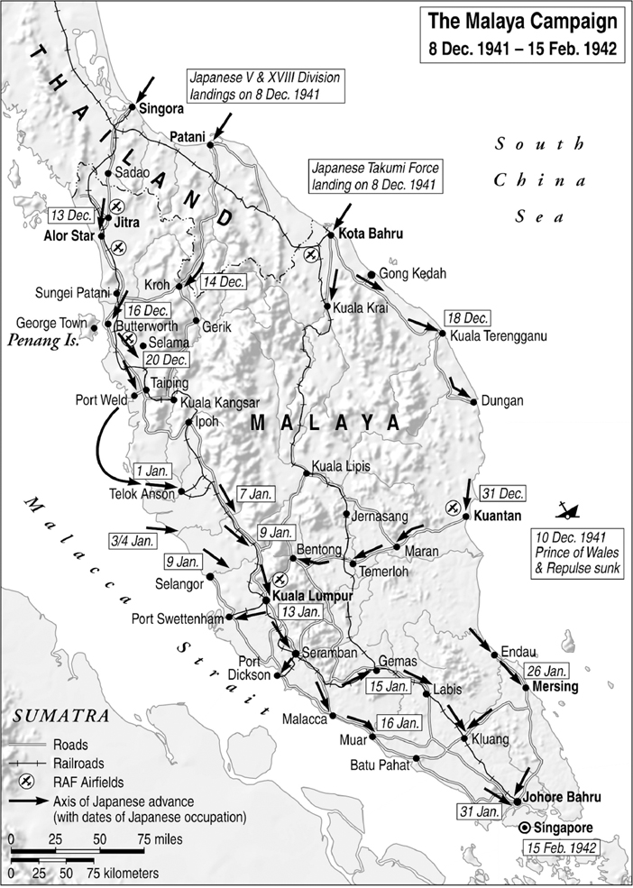
At the very tip of the Malay Peninsula, across the Straits of Johore, named after the Sultan of Johore, was Singapore Island, which was the epicentre of Britains defensive plans in the Far East. Singapore is a wet low-lying island 85 miles north of the equator covering about 240 square miles with some of its coastline fringed by mangrove swamp. It extends 27 miles from east to west and 13 miles (at its maximal width) from north to south. The Straits of Johore, which separates the Malay Peninsula from Singapore Island, has a width that varies from 600 to 5,000 yards, and near the narrowest point the British constructed a causeway. Most of the coastline is coursed by creeks and small rivers. Most of the roads lead to Singapore City, located on the southern shore of the island towards its eastern end. In 1941, the islands population was approximately 550,000 inhabitants, comprised of Malays, Chinese, a few Tamils and Europeans, and most of the population lived in Singapore City. Except for scattered towns and settlements, the rest of the island was covered with rubber plantations and jungle growth.
The British High Command, as well as its political leaders, believed Singapore Island to be impregnable, as it had strongly fortified the southern and eastern coasts of the island with large calibre naval guns against seaborne assault. Singapores main port was located at Keppel Harbour, which lies on the islands southern coast on the eastern end of the Malacca Straits, which separate Malaya and Singapore from the elongated island of Sumatra. It was not the 15-inch naval artillery guns of the Buona Vista and Johore batteries that concerned the Japanese High Command during their offensive strategy planning sessions in the autumn of 1941, but rather the fear that British Royal Air Force (RAF) and Royal Australian Air Force (RAAF) aircraft (with some Dutch Air Force aircrew as well) stationed on Singapore and at multiple airfields on the Malay Peninsula could interdict Japanese lines of communications (LOC), and potentially interfere with scheduled Imperial Japanese Army (IJA) offensives in resource-rich Sumatra and Java. Because of this geo-strategic position for Singapore, with numerous RAF and RAAF airfields, both Malaya and Singapore had to be captured before any subsequent operations against Java and Sumatra could be mounted.
After the carrier attack by the Imperial Japanese Navy (IJN) on Pearl Harbor, Hawaii, on 7 December 1941, the IJA conducted offensive operations across an incredibly broad front of 7,000 miles from Singapore to Midway Island. From early war planning sessions, Malaya and Singapore were targets for the IJAs major thrust while additional supporting operations were mounted to seize the Philippines, Guam, Hong Kong and parts of British Borneo in the Western Pacific. The Japanese High Command planned that once Malaya and Singapore were captured, these British bastions would serve as a springboard to seize southern Sumatra and an invasion of the Netherland East Indies (NEI) with its vast resources to supply Japan and its war effort, which had been occurring on the Asian mainland for almost a decade. Finally, southern Burma would be invaded with the intent of defeating the British and Indian forces there in order to sever the Burma Road and, thus, Chiang Kai-shek and his armys supply lifeline through the Burmese port of Rangoon. Ironically, the IJA utilized only eleven of its fifty-one divisions during these offensive operations in southern Asia, reserving the majority for home defence, continued offensives on the Chinese mainland and to possess a sufficient force in Manchuria to counter any possible Soviet moves against Japan there. This was to become, indeed, Imperial Japans high-water mark.
Next page
