E-book published in 2012 by Encyclopdia Britannica, Inc., in association with Arcturus Publishing Limited, 26/27 Bickels Yard, 151-153 Bermondsey Street, London SE1 3HA. Britannica, Encyclopdia Britannica, and the Thistle logo are registered trademarks of Encyclopdia Britannica, Inc.
ISBN 978-1-61535-637-9 (e-book)
This edition first published by Arcturus Publishing
Distributed by Black Rabbit Books
P.O. Box 3263
Mankato
Minnesota MN 56002
Copyright 2008 Arcturus Publishing Limited
Library of Congress Cataloging-in-Publication Data
Barker, Geoff, 1963
Iraq / Geoff Barker.
p. cm. -- (Changing world)
1. Iraq--Juvenile literature. I. Title.
DS70.62.K66 2009
956.7--dc22
2008016658
The right of Geoff Barker to be identified as the author of this work has been asserted by him in accordance with the Copyright, Designs and Patents Act 1988.
All rights reserved.
Series concept: Alex Woolf
Editor: Alex Woolf
Designer: Ian Winton
Illustrator: Stefan Chabluk
Picture researcher: Alex Woolf
Picture credits:
Art Archive: 12 (Turkish and Islamic Art Museum, Istanbul/Alfredo Dagli Orti).
Corbis: cover left (Peter Turnley), cover right (Ali Abbas/epa), 6 (Nik Wheeler), 7 (Ed Kashi), 10 (Bettmann), 11 (Abilio Lope), 14 (Slhaldeen Rasheed/Reuters), 15 (In Visu/Corbis), 16 (Patrick Robert/Sygma), 17 (Ali Abbas/epa), 19 (Thaier al-Sudani/Reuters), 20 (Michael S Yamashita), 22 (Ceerwan Aziz/Reuters), 23 (Cheryl Diaz Meyer/Dallas Morning News), 24 (Stephanie Sinclair), 26 (Iraqi Prime Minister Office/Handout/epa), 27 (Ceerwan Aziz/Pool/epa), 28 (Thaier al-Sudani/Reuters), 31 (Ali Haider/epa), 32 (Faleh Kheiber/Reuters), 35 (Ali Abbas/epa), 39 (Aladin Abdel Naby/Reuters), 40 (Youssef Badawi/epa), 43 (Patrick Robert).
Getty Images: 13 (AFP), 25 (AFP), 36, 37 (AFP), 38, 41 (AFP).
The illustrations on pages 8, 9, 18, 30, and 33 are by Stefan Chabluk.
Cover captions
Left: On April 10, 2003, the day after US troops entered the center of Baghdad, a crowd toppled a statue of Saddam Hussein near the Palestine Hotel.
Right: Iraqi pupils sit in their classroom at one of Baghdads elementary schools on the second day of the new school year, September 13, 2005.
Every attempt has been made to clear copyright. Should there be any inadvertent omission, please apply to the copyright holder for rectification.
Contents
CHAPTER 1
Introduction

I raq lies at the very heart of the Middle East, like a triangular-shaped wedge between the countries of Saudi Arabia, Syria, and Iran. It also shares much shorter borders with Kuwait to the southeast, Jordan to the west, and Turkey in the north. Todays Iraq was once known as the ancient land of Mesopotamia, or land between the rivers, of the Tigris and Euphrates. The lands fertile soils made it a natural site for some of the worlds earliest civilizationsSumerians, Akkadians, Babylonians, and Assyrians. Underneath its soil lies Iraqs richest resource: oil. Iraq now has the worlds third-largest proven conventional crude oil reserves.
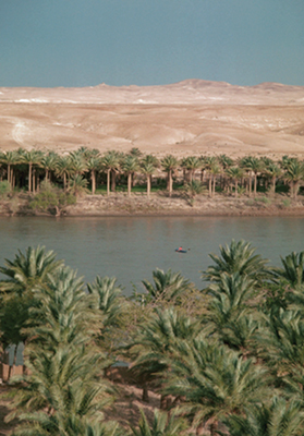
Many ancient cities grew up along the banks of the Euphrates River. At nearly 1,736 mi (2,800 km) long, the river runs from Turkey to the Persian Gulf. Much of its central section, like here in Khan al-Baghdadi in the province of al-Anbar, is lined with date palm groves.
PHYSICAL GEOGRAPHY
Area:
total: 170,458 sq mi (437,072 sq km)
land: 168,543 sq mi (432,162 sq km)
water: 1,915 sq mi (4,910 sq km)
Highest point: unnamed peak11,844 ft (3,611 m) (local Kurdish name: Cheekha Dar, or black tent)
Lowest point: Persian Gulf0 ft (0 m)
Land boundaries:
total: 2,263 mi (3,650 km)
border countries: Iran 904 mi (1,458 km), Jordan
112 mi (181 km), Kuwait 149 mi (240 km), Saudi
Arabia 505 mi (814 km), Syria 375 mi (605 km),
Turkey 218 mi (352 km)
Coastline: 36 mi (58 km)
Source: CIA World Factbook
Lowlands, deserts, and mountains
Situated in central and southeastern Iraq, the broad floodplains of the Tigris-Euphrates basin make up about a third of the country. Much of this land has rich soil that was once ideal for agriculture. However, it has been over-irrigated, and some of it has been abandoned owing to its high salt content. Although lowlands form much of the landscape of Iraq, highlands rise to the north and northeast, including the high elevations of the Kurdistan region. The Anti-Taurus and Zagros mountains form the borders with Turkey and Iran respectively. Between Iraqs two great rivers in the north is an arid plateau in an upland region known as al-Jazirah, or the island. Here, the Sinjar Mountains rise to a height of over 4,920 ft (1,500 m). Forty percent of Iraqs land area consists of vast deserts in the west and south, including the western desert region, called Wadiyah, which is almost 1,640 ft (500 m) above sea level.
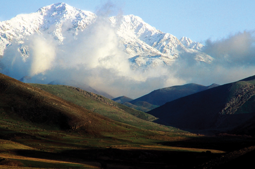
The Zagros Mountains, in the northeastern region of Iraq, form a natural geographic barrier between Iraqs central plains and the Iranian plateau to the east. Mostly situated in Iran, the Zagros range is about 558 mi (900 km) long and 2149 mi (40 km) wide.
Two rivers
Iraqs two mighty rivers, the Tigris and the Euphrates, begin their journey farther north in Turkey and flow in a southeasterly direction along roughly parallel courses through the country until they meet at the southern Iraqi town of al-Qurnah. The merged river, called the Shatt al-Arab, or stream of the Arabs, continues south for the final 124 mi (200 km) of its route to the coast. The Shatt al-Arab passes the port of Basra, where it forms part of the eastern boundary with Iran, before finally emptying into the Persian Gulf. With Kuwait to the west and Iran to the east, Iraqs coastline on the Persian Gulf is a short stretch of only 36 mi (58 km).
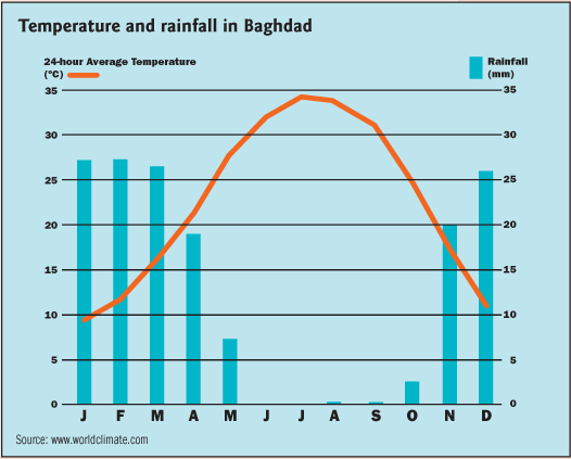
This chart shows the climate of Baghdad. Situated in Iraqs central plains, the city has average daily temperatures of nearly 95F (35C) in July and August.
Temperatures as high as 124F (51C) have been recorded in the summer.
Climate
Most of Iraq, including the lowlands, experiences long, hot, dry summers lasting from May to October, although the weather can be more humid near the rivers. Winters are short and mild, with almost all rain falling between November and April. Desert regions have blisteringly hot, dry summers, while the damper northeast of the country has shorter, cooler summers. Precipitation in the northeastern highlands can be in excess of 39 inches (1,000 mm) during the year, much of which falls during the winter as snow. Heavy snows melting in spring can cause flooding farther south in central and southern Iraq.
Culture
Next page


