1.1 Introduction
Colombias agrarian history has traditionally been focused on land tenure and relations of production. However, little is known about farming practices, land use and management, and the transformation of ecosystems. This research addresses these issues in the Bogota Plateau, a region dominated by the Bogota River. The period being analyzed spans the eighteenth century and the first decades of the nineteenth century; an era defined by the gradual disappearance of indigenous reservations (in Spanish, resguardos ) and the dominance of haciendas. The key primary sources are the reports of European travelers in the region, and the documentary collections of the Archivo General de la Nacin (Bogota, Colombia), where it is possible to find records about meat supplies, disputes over the land and water, infrastructure demands (trenches, ditches, channels, and bridges), inventories of Jesuit haciendas expropriated, visits to the resguardos , letters between the majordomos and the landowners, and maps. The analysis highlights the unique land use and management decisions that characterized agriculture in the Bogota Plateau. This research examines livestock specialization and hydraulic modifications that farmers made spontaneously and informally in order to increase production. Also, it describes farming practices characteristic of the region, including white landowners engaged in farming across micro-climates, an agricultural practice that has been traditionally defined as Indigenous. Agriculturalists also engaged in more typical Spanish agriculture, including the temporary grazing of herds coming from long distances and lower altitudes. Farmers in the Bogota Plateau were involved in the expansion of the pastures as the main land cover and the land use for livestock in the wetlands, and the construction of trenches and ditches for saving the water during droughts, draining of wetlands and diverting the rivers course. Using the socio-ecological metabolism approach, this research emphasizes the importance of understanding the human appropriations of ecosystems and the limits of this process. Results contribute to the understanding of traditional farm system dynamics and offer lessons for more sustainable agrarian production in the region today.
1.2 The Region
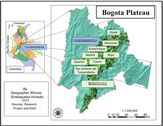
The Bogota Plateau is in the center of Colombia, between 0430 y 0515N and 7345 y 7430W. It is a part of the Cundiboyacense High Plateau, one of the high plateaus in the Eastern Andes of Colombia (Fig. , 27).
Fig. 1.1
Bogota Plateau location
The Bogota Plateau is characterized by a bimodal precipitation regime, with two annual rain periods (March-May and October-November) and two annual dry periods (December-February and June-August). The annual precipitation in the Plateau oscillates between 2000 mm in the East and 600900 in the West, the driest area in the Plateau (IGAC , 82).
For this research, I selected the west of the Plateau. First, the precipitation in this area is far less than in the rest of the Plateau, ranging between 600 and 900 mm. However, the area is still much more vulnerable to flooding because of its mild inclination which directs rainwater to this zone and the overflows of the rivers, lagoons, and swamps. Second, this is the best documented area of the Plateau, with existing studies on the grasslands of Bogota, the Jesuit hacienda La Chamicera and five reservations (in Spanish, resguardos ) called Bogota , Bojac , Bosa , Fontibn y Engativ . Third, the selection is consistent with the cultural construction of the concept Sabana de Bogot (is not a savanna ecosystem, but this name was given to the region in colonial times based on its flat appearance), used until the nineteenth century for name the flat zone in the West near of Funza , the ancient Indian town named Bogot (Rueda Vargas , 10). Currently, the name Sabana is used for entire Plateau.
The current floods that periodically take place in the Plateau, especially in the years of La Nia, have frequently devastated cattle herds, potatoes and flowers crops. However, these are not the point of reference for analyzing the floods of 200300 years ago. The channeling, drainage, and damming works since the half of twentieth century in the Bogota Basin, have changed the conditions of the rivers. The deforestation, the drainage and filling of wetlands, the spread of covered greenhouses used for growing flowers, and the paving of the capital city (that prevents infiltration of the rain into aquifers and promotes the runoff to the west of the Plateau), are the factors that increase the dimensions of floods. Apparently, before the nineteenth century, the overflows of the Funza or Bogota River, were not a great problem. On the contrary, these floods left silt behind which favored agriculture and livestock (Cordovez Moure ). Before this process, how were used the wetlands of the Plateau by the farmers? What were the ways to deal the floods?

