Stein - How the States Got Their Shapes
Here you can read online Stein - How the States Got Their Shapes full text of the book (entire story) in english for free. Download pdf and epub, get meaning, cover and reviews about this ebook. City: New York;NY;Pymble;NSW;United States, year: 2009, publisher: HarperCollins ebooks, genre: Politics. Description of the work, (preface) as well as reviews are available. Best literature library LitArk.com created for fans of good reading and offers a wide selection of genres:
Romance novel
Science fiction
Adventure
Detective
Science
History
Home and family
Prose
Art
Politics
Computer
Non-fiction
Religion
Business
Children
Humor
Choose a favorite category and find really read worthwhile books. Enjoy immersion in the world of imagination, feel the emotions of the characters or learn something new for yourself, make an fascinating discovery.
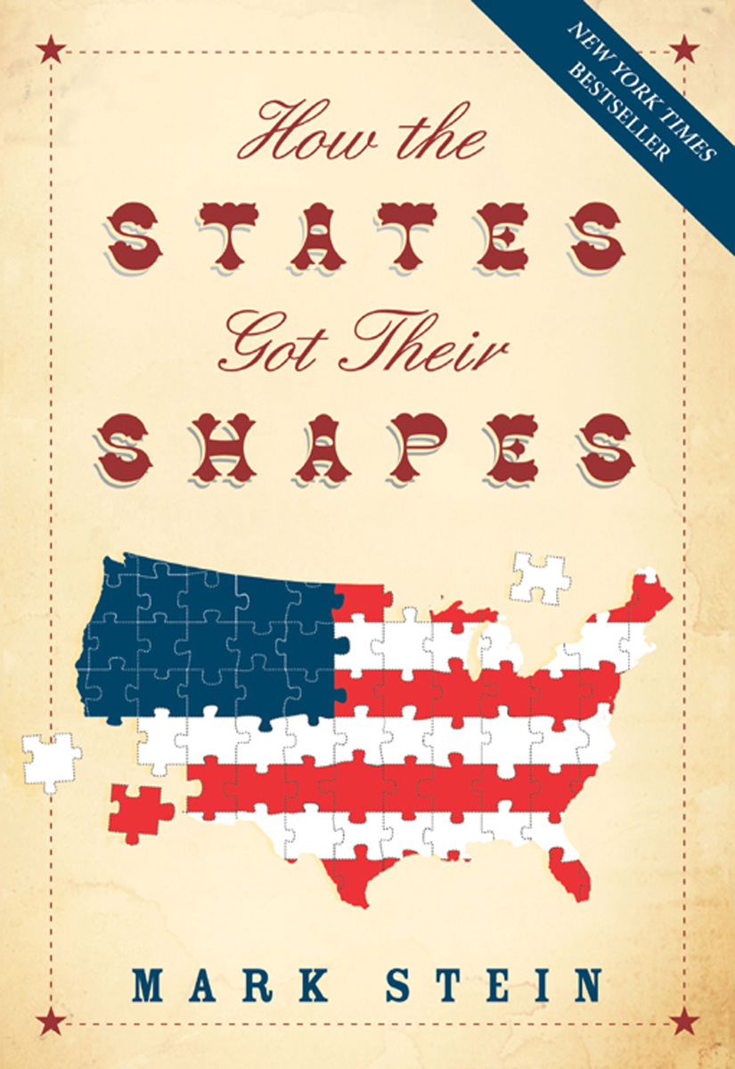
How the States Got Their Shapes: summary, description and annotation
We offer to read an annotation, description, summary or preface (depends on what the author of the book "How the States Got Their Shapes" wrote himself). If you haven't found the necessary information about the book — write in the comments, we will try to find it.
Stein: author's other books
Who wrote How the States Got Their Shapes? Find out the surname, the name of the author of the book and a list of all author's works by series.


How the States Got Their Shapes — read online for free the complete book (whole text) full work
Below is the text of the book, divided by pages. System saving the place of the last page read, allows you to conveniently read the book "How the States Got Their Shapes" online for free, without having to search again every time where you left off. Put a bookmark, and you can go to the page where you finished reading at any time.
Font size:
Interval:
Bookmark:
![]()
In memory of Caroline Newman
1951-2008
I would like to acknowledge the men and women of the U.S. Geological Survey who created the National Atlas of the United States. This interactive Web site has been of immense value to me in preparing this work. Of even greater value has been Caroline Newman, Executive Editor at Smithsonian Books. I now know what authors mean when they praise their editors for having vitally important insight and perseverance. I am also deeply indebted to our copyeditor, Cecilia Hunt, and to our cartographer, Rob McCaleb of XNR Productions, whose keen eyes not only detected errors but also led me to new discoveries. And lastly, my heartfelt thanks to Arlene Balkansky of the Library of Congress, who is my wife. I would urge any young person entering a career that involves research to marry an employee of the Library of Congress.
I am also deeply indebted to the Geography and Map Division at the Library of Congress, whose online historical maps provided a treasure trove of information, and whose reference staff led me to resources without which I never would have found the reasoning behind several state borders.
Following this books initial publication, a number of readers called my attention to various oversights. These readers include every memer of my family. For these contributions, I want to thank my wife, my sons, Harry and David, and my sister, Roberta Redfern. I also want to thank Marcia Bjornerud, Douglas F. Burns, Eugene Fernstrom, Daniel L. Goldberg, James Hand, Manus Hand, Jamie Heller, Keith Karamanos, Jack Ritter-skamp, Michael Rodman, Robert C. Ross, and Peter G. Wolfe. I am especially appreciative of insights I received from Stan Vitton regarding the boundaries of Georgia and Alabama.
T o teach us the boundaries of the states, my seventh grade geography teacher would hold up cutouts and we would raise our hands, vying for the chance to identify which state had the corresponding shape. How we distinguished Wyoming from Colorado, both rectangles, eludes me these many years later. Maybe she just didnt include them. After all, how much value is there in knowing which rectangle is Wyoming and which is Colorado?
Later in life, I came to realize that there is value in learning about the borders of Colorado and Wyoming, but that value resides, not in knowing what their shape is, but in knowing why it is. Why, for instance, are the straight lines that define Wyoming located where they are and not, say, ten miles farther north or west? Far more knowledge results from exploring why a set of conditions exists than from simply accepting those conditions and committing them to memory. Asking why a state has the borders it does unlocks a history of human strugglesfar more history than this book can contain, though this book does aspire to unearth the keys.
Consider for a moment the cluster of states composed of Maine, New Hampshire, and Vermont. Why dont those states extend to their natural boundaries, the St. Lawrence River and the Atlantic Ocean? How come Canada got that land? (Figure 1)
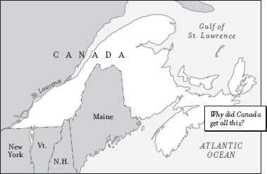
FIG. 1 U. S./Canadian Border
Why does Delaware have a semicircle for its northern border? Whats at its center and why was it encircled? Why does Texas have that square part poking up? And why does the square part just miss connecting with Kansas, leaving that little Oklahoma panhandle in between? (Figure 2)
The more one looks at state borders, the more questions those borders generate. Why do the Carolinas and Dakotas have a North state and a South state? Couldnt they get along? Why is there a West Virginia but not an East Virginia? And why does Michigan have a chunk of land thats so obviously part of Wisconsin? Its not even connected to the rest of Michigan! (Figure 3)
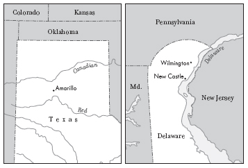
FIG. 2 Border Curiosities: Panhandles and Semicircles
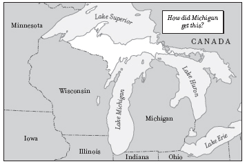
FIG. 3 Wisconsin/Michigan Border
This book will provide those answers. State by state (along with the District of Columbia), the events that resulted in the location of each states present borders will be identified.
A state border is both an official entrance and a hidden entrance. The official entrance is the legal threshold to a state. But its hidden entrance beckons us to the past. Here at the state line we can come in contact with struggles long forgotten and now overgrown by signs saying things like Welcome to KansasPlease Drive Carefully.
M any of our state borders are segments of borders that date from Englands and, later, the United States territorial acquisitions, and they can be identified by looking for lines that provide multistate borders.
The French and Indian War Border
The French and Indian War (175463) resulted in the oldest of these multistate boundaries. In this war, England and her American colonists began what became the dismantling of Frances possessions in North America. With this victory, England added to her North American possessions all the land between the Ohio River and the Mississippi River. The boundaries of that war are still on the map today, for they provide borders for the states of Ohio, Indiana, Illinois, and Wisconsin. (Figure 4)
The division of this land acquired in the French and Indian War influenced virtually every state border that followed. After the Revolution, Congress had to decide how best to divide this region, known as the Northwest Territory, into states. Congress assigned Thomas Jefferson the task of studying this matter and in 1784 Jefferson issued a report to Congress in which he proposed that the region be divided into states having two degrees of height and four degrees of width, wherever possible.
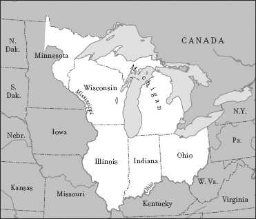
FIG. 4 Land Acquired in the French and Indian War
As it turned out, Congress didnt employ these borders when it enacted the Northwest Ordinance in 1787, the law that included the boundary lines for the future states to be created from the Northwest Territory. Congress did, however, adopt its underlying principle: All states should be created equal.
The Louisiana Purchase Borders
Probably the most notable American boundary is the long straight line that defines so much of the nations northern border with Canada. This line is the 49th parallel. It first surfaced on the American map following the 1803 Louisiana Purchase. The document conveying Frances remaining North American landa tract that included all or some of Louisiana, Arkansas, Oklahoma, Missouri, Kansas, Iowa, Nebraska, South Dakota, North Dakota, Wyoming, Minnesota, Montana, and Coloradostates that the French Republic cedes to the United States the Colony or Province of Louisiana with the same extent that it now has. This wording seems refreshingly brief and to the point for a legal document, if a bit vague. The vagueness is also the reason very little evidence of the Louisiana Purchase can be found in our state lines. Other than the boundaries provided by the Gulf of Mexico and the Mississippi River, no one knew what its boundaries were! Jefferson believed that all the land comprising the watershed leading to the Missouri and Mississippi rivers constituted the Louisiana Purchase. But, as he soon discovered, the United States neighbors did not. In reality, Frances American territory extended to the west as far as a Frenchman could go without getting shot by a Spaniard, and likewise to the north without getting shot by an Englishman. (Figure 5)
Font size:
Interval:
Bookmark:
Similar books «How the States Got Their Shapes»
Look at similar books to How the States Got Their Shapes. We have selected literature similar in name and meaning in the hope of providing readers with more options to find new, interesting, not yet read works.
Discussion, reviews of the book How the States Got Their Shapes and just readers' own opinions. Leave your comments, write what you think about the work, its meaning or the main characters. Specify what exactly you liked and what you didn't like, and why you think so.