Ukraine
An Illustrated History
Paul Robert Magocsi

University of Toronto Press Incorporated 2007
Toronto London
Printed and bound in Canada
ISBN 978-0-8020-8701-0
 Printed on acid-free paper
Design and layout by Gabriele Scardellato.
Library and Archives Canada Cataloguing in Publication
Magocsi, Paul Robert
Ukraine: an illustrated history / Paul Robert Magocsi.
Includes index.
ISBN 978-0-8020-8701-0 (bound)
1. Ukraine--History--Textbooks. 2. Ukraine--Historical geography--Maps--Textbooks. I. Title.
DK508.157.M34 2007 947.7 C2007-900913-1
University of Toronto Press acknowledges the financial assistance to its publishing program of the Canada Council for the Arts and the Ontario Arts Council.
This book has been published with the help of grants from the Chair of Ukrainian Studies Foundation in Toronto, and from the Humanities and Social Sciences Federation of Canada, using funds provided by the Social Sciences and Humanities Research Council of Canada.
University of Toronto Press acknowledges the financial support for its publishing activities of the Government of Canada, through the Book Publishing Industry Development Program (BPIDP).
Contents
List of Tables
List of Maps
Introduction
Ukraine is EuropeS second largest sovereign state. For this reason alone it has become in recent decades the subject of numerous studies, including several large-scale historical surveys. History can best be understood when the reader has access to maps. The purpose of this book is to provide a concise historical survey of Ukraine from earliest times to the present through means of a text that has been constructed around forty-six historical maps. Therefore, the book may function for some readers as a brief introductory history, while for others it may be used as a historical atlas to supplement and assist readers of other publications about Ukraine.
In contrast to most other histories of Ukraine, this book adopts what might be called the territorial, or multicultural approach. Since Ukraine is a territory which in the past and present has been inhabited by numerous peoples, the cultures and achievements of all those peoples are what comprise the Ukrainian historical process. In other words, developments connected specifically with Crimean Tatars, or Poles, or Jews are also part of Ukrainian history if they occurred at some time on territory within the present-day boundaries of Ukraine. nevertheless, it is not surprising that ethnic Ukrainians receive the most attention, since they have historically comprised the majority of Ukraines inhabitants.
The author is grateful to several colleagues who have helped in the production of this volume. Serhiy Bilenky (University of Toronto), Maryna Kravets (University of Toronto), Victor Ostapchuk (University of Toronto), Serhii Plokhy (University of Alberta), Murat Yaar (University of Toronto), and Serhy Yekelchyk (Victoria University) provided invaluable critical commentary on an earlier draft of the text and maps. Of particular importance is the editorial work of Harold Otto and Kate Baltais, whose general historical knowledge and stylistic skills have markedly improved the text. The maps prepared by the author were transformed into their final form by Jane Davie of the Cartography Office at the University of Torontos Department of Geography.
Place names for the most part follow the principles established in Paul Robert Magocsi, Historical Atlas of Central Europe, 2 nd rev. ed. (Seattle, Toronto, and London, 2002), which in turn are based on the main forms listed in Merriam-Websters Geographical Dictionary, 3 rd ed. (Springfield, Mass., 1998).
Nadiya Kushko (University of Toronto) was responsible for inputting the manuscript, for factual emendations, and for help in standardizing Ukrainian proper names. Finally, the Chair of Ukrainian Studies Foundation under its President Ihor Bardyn provided the essential funding to cover cartographic costs. While all the above individuals helped to improve the book, the responsibility for any shortcomings that still exist rests entirely with the author.
Toronto, Ontario
June 2005
1
Ukraines Physical Geography
The present-day independent state of Ukraine is territorially the second largest country in Europe. It comprises 232,200 square miles (603,700 square kilometers), which for comparative purposes is roughly the equivalent size of Germany and Great Britain combined, or of the states of Arizona and New Mexico combined, or of the province of Manitoba in Canada.
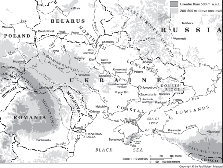
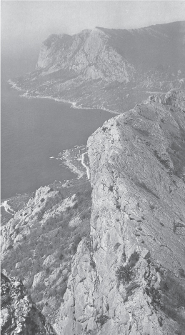
Ukraines physical geography is not complex, and most of its territory consists of lowland plains and plateaus that at their highest rise to about 1,600 feet (500 meters) above sea level. These include the Northern Lowlands and Coastal Lowlands, generally referred to as the steppe; that is, a plain which in its natural state is covered with a wide variety of lush grasses and shrubs. The lowland steppe is only interrupted in the west by the Volhynian-Podolian Plateau and in the far east by the Donets Ridge. Higher elevations are found only along the far edges of Ukraine: the Carpathian Mountains in the west, and the Crimean Mountains along the southern tip of the Crimean peninsula as it juts out into the Black Sea. The highest Carpathian peak is Hoverla (6,760 feet or 2,061 meters), the highest Crimean peak is Roman Kosh (5,061 feet or 1,543 meters). Mountainous regions account for only 5 percent of Ukraines landscape. Therefore, with the exception of the Carpathians, Ukraine lacks any natural barriers, and this has historically facilitated the movement of peoplesboth friendly and unfriendlywhose aim may have been to settle, to conquer, or simply to pass through the country.
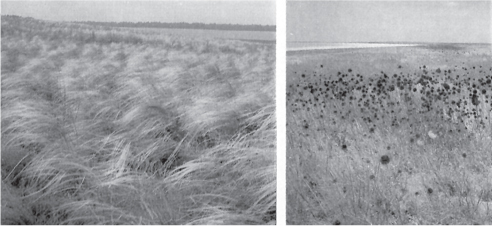
1.1 The grassland and shrub-covered steppe of southern Ukraine.
MAP 1 GEOGRAPHIC FEATURES
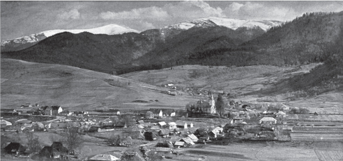
1.2 Carpathian Mountain peaks beyond the town of Volovets in the Transcarpathian oblast.
Communication has traditionally been facilitated by a network of rivers throughout plains and plateaus. Most run in a roughly north-south direction and are part of the Black Sea or Pontic Watershed. The center of Ukraine is dominated by the Dnieper (Ukrainian: Dnipro) River, historically a major communication route on whose banks is located the countrys capital city, Kiev (Ukrainian: Kyv). Traditionally the course of the Dnieper River has functioned as the dividing line between two of Ukraines most important territorial, administrative, and geographic regions: the Left Bank to the east of the river, and the Right Bank to the west. During the twentieth century, the Dnieper was transformed into a major source of hydroelectric power, thanks to the construction of several dams which created at least five large-scale reservoir lakes: Kiev, Kaniv, Kremenchuk, Dniprodzerzhynsk, and Kakhovka.








 Printed on acid-free paper


