IMAGES
of America
LAYTON

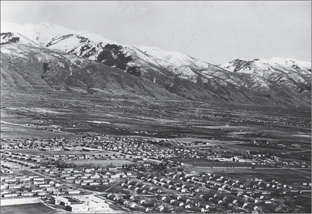
This is a mid-1940s aerial view of Layton that reveals the enormous size of Verdeland Park (bottom housing cluster). In 1943, approximately 1,440 residents lived in 400 housing units there on 85 acres. With World War II raging, hundreds of civilian workers came to Layton to work in the defense industry at Hill Field and the Navy Supply Depot in Clearfield and lived in this federal housing. When Verdeland Park was being built, Laytons total population was only 960. Eventually, the 85 acres became Layton Commons Park, Layton High School, and Layton Municipal Center. (Courtesy of Heritage Museum of Layton.)
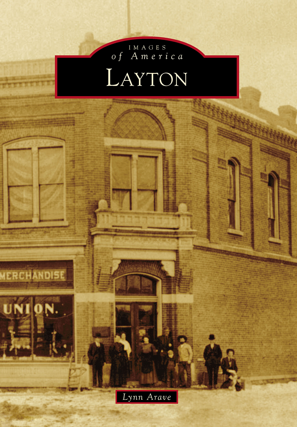
ON THE COVER: The Layton Farmers Union Building, at 12 South Main Street, is shown in a wintertime picture of the 1910s. The people in front of the bank may be E.P. Ellison, Farmers Union superintendent, and some family members. The frame store opened in 1882 as the Kaysville Farmers Union. There was a dance hall upstairs, and that feature led to many marriages in town. Later, apartments opened upstairs, along with dentist R.C. Robinsons office, which operated from 1922 to 1968. There was also a connecting wooden annex building (not shown) on the left (south) side of the main building for many years. At the corner of Main and Gentile Streets, Farmers Union operated until 1957. First National Bank of Layton moved into the building in 1981, and now it houses First Community Bank Utah. Given Laytons agricultural roots, this former business that catered to farmers, as well as Layton Citys modern prowess as a regional retail hub, makes this approximate-century-old store picture on the books cover very appropriate. (Courtesy of Heritage Museum of Layton.)
IMAGES
of America
LAYTON
Lynn Arave

Copyright 2019 by Lynn Arave
ISBN 978-1-4671-0496-8
Ebook ISBN 978-1-4396-7152-8
Published by Arcadia Publishing
Charleston, South Carolina
Library of Congress Control Number: 2019955559
For all general information, please contact Arcadia Publishing:
Telephone 843-853-2070
Fax 843-853-0044
E-mail
For customer service and orders:
Toll-Free 1-888-313-2665
Visit us on the Internet at www.arcadiapublishing.com
To the people of Layton
CONTENTS
ACKNOWLEDGMENTS
The author especially thanks Bill Sanders, museum curator at the Heritage Museum of Layton, for collecting and scanning the majority of the photographs in this book and for his extensive historical knowledge. The museum already had most of the pictures contained herein in its large collection.
Unless otherwise noted, all images in this book appear courtesy of the Heritage Museum of Layton.
Also, many thanks and appreciation are due to Harris Adams, a longtime Layton historian, for his remarkable knowledge and expertise. At age 90, Harris still has a keen memory, and his reflections of Laytons historyand some photographs from his collectionproved invaluable to this book.
The 1985 book Layton, Utah Historical Viewpoints, by the Kaysville-Layton Historical Society, was relied upon heavily for reference in this work and is recommended for anyone wanting to further study Laytons history. The Heritage Museum of Layton is another great local history resource.
The Utah Division of State History also provided some photographs for this book from its digital collection.
Several family members of the author, including sons Roger Arave and Taylor Arave, plus daughter-in-law Whitney Arave, contributed photographs to this book and other assistance. The authors wife, LeAnn Flygare Arave, also contributed valuable advice on the book.
Note that the author also maintains several historical blogs on Google, including Mystery of Utah History and Layton, Utah History. Their content supplemented some material in this book.
In addition, as a matter of disclosure, the author was employed on a limited part-time basis as a news specialist for Layton City Corporation when he wrote this book.
INTRODUCTION
Layton is a Western community with a strong pioneer heritage and marked its 100th birthday as an official city in 2020. It is named after Christopher Layton, an early pioneer and church leader in Layton.
Layton, Utah, is by far the largest of the four total Laytons in the United States and the only one in the west. (The other three Laytons are in Florida, New Jersey, and North Dakota.)
Layton is located in the northern section of the Salt Lake Valley, bordered by the Wasatch Mountains to the east and the Great Salt Lake to the west. Salt Lake City is 23 miles south, and Ogden is some 11 miles north.
The Layton area and Salt Lake Valley is an old lake bed for ancient Lake Bonneville, which covered the land with fresh water up to 1,000 feet deep. The Great Salt Lake is a remnant of Lake Bonneville.
There are six major creeks within Layton Citys borders, some with smaller tributaries. It was these sources that gave early pioneers their water.
The elevation difference in the Layton area goes from Thurston Peak, east of the city (and highest in Davis County), 9,706 feet above sea level, down to approximately 4,280 feet on its extreme western side.
Layton is also known for its seasonal sentinel on the mountainside each springthe Snow Horse. Deep gullies naturally create a horse-like shape each late May into early June on average. This figure was a pioneer landmark each spring, and if any part of it remained into July, it meant continuous water all summer from the streams that flow into Layton from the Wasatch Mountains.
The climate in Layton is one of four seasons and receives an average of about 22 inches of moisture annually. Historically, Laytons hottest month is July, and the coldest is January. Its wettest month is April, and July is the driest. The hottest temperature ever recorded in Layton City was 105 degrees. This has happened twice: on July 14, 2002, and July 18, 1998. Layton has reached 104 degrees on two other occasions: on July 19, 1998, and July 4, 2001.
Although no exact temperature records were kept in Layton in the early 1930s, its coldest day ever was likely either February 9 or February 10 in 1933, at probably around minus 30 degrees.
December 2531, 2003, was likely Laytons snowiest-ever-recorded period, when the east bench of Layton received 51 inches of snow.
Like most of Davis County, gusting canyon winds in excess of 100 miles per hour during the spring and fall periodically plague Layton too. It is rare, but several tornadoes have also touched the ground in Layton over its recorded history.
Layton is one of Utahs 10 largest cities and is the biggest in Davis County, having overtaken Bountiful in population in 1985. Laytons population was approaching 80,000 in 2019. The city covers 22.49 square miles and has 315.5 miles of city streets.
The community began as an agricultural area, bolstered by the completion of the Davis and Weber County Canal in 1885 and East Canyon Reservoir in 1899. Two different railroad lines through town also made for handy produce and livestock shipping, as well as transportation.
Layton developed a robust downtown business area early on and boasted a few major industries in the early 20th century: the Layton Sugar Factory and the Layton Roller Mills (flour).
Layton is an outgrowth of neighboring Kaysville. It became a separate community in 1902 and incorporated as a city on May 24, 1920.
Next page


