Part I
Geology
Springer-Verlag Berlin Heidelberg 2016
Franco Tassi , Orlando Vaselli and Alberto Tomas Caselli (eds.) Copahue Volcano Active Volcanoes of the World 10.1007/978-3-662-48005-2_1
1. A Review of the Geology, Structural Controls, and Tectonic Setting of Copahue Volcano, Southern Volcanic Zone, Andes, Argentina
A. Folguera 1 , E. Rojas Vera 1, L. Vlez 1, J. Tobal 1, D. Orts 1, M. Agusto 1, A. Caselli 2 and V. A. Ramos 1
(1)
Facultad de Ciencias Exactas y Naturales, Instituto de Estudios Andinos (IDEAN), Universidad de Buenos Aires-CONICET, Buenos Aires, Argentina
(2)
Facultad de Ciencias Exactas y Naturales, Universidad de Ro Negro e Instituto de Estudios Andinos (IDEAN), Universidad de Buenos Aires, Buenos Aires, Argentina
Abstract
Copahue Volcano lies in the Southern Volcanic Zone of the Andes Mountains, although its geology and local structural controls differ from nearby active volcanic centers. Most of its geology is substantially older than active volcanoes at these latitudes, as the postglacial component is relatively minor. The basement of Copahue Volcano, represented by the Agrio Caldera products and its basal sections, accumulated in extensional depocenters when the arc narrowed from a broad geometry on both sides of the Andes to its present configuration. Initial stages comprise early Pliocene basaltic-andesitic eruptions associated with extensional (transtensional?) processes that ended with the formation of a series of rhombohedral calderas that emitted important amounts of ignimbrites in latest Pliocene-early Pleistocene time. Copahue Volcano concentrates the Pleistocene activity of one of these calderas, the Agrio Caldera, before the emplacement and development of the Present arc front to the west. Volcano morphology reflects this particular evolution, looking more degraded than Antuco, Callaqui and Lonquimay volcanoes located immediately to the west in the arc front. Most of Copahues volume is early Pleistocene in age, showing a thin resurfacing cover in synglacial (>27 ka) and postglacial times. A synglacial stage occurred mainly to the east of Copahue Volcano toward the caldera interior in a series of independent, mostly monogenetic centers. Postglacial eruptions occurred as both central and fissural emissions reactivating the old Pleistocene conduits. Its particular geological record and eastern longitudinal position indicate that Copahue was probably part of the late Pliocene-Pleistocene arc mostly developed in the axial and eastern Andes. Narrowing and westward retraction of the arc front, proposed in previous works for the last 5 Ma at 38S, could have been the result of the eastward migration of the asthenospheric wedge during slab steepening. Reasons for this long-lived eruptive history at Copahue volcano could be related to the particular geometry of the active Liquie-Ofqui dextral strike-slip fault system that runs through the arc front from south to north when penetrates the retroarc area at the latitude of Copahue volcano. This behavior could be due to the collision of the oceanic Mocha plateau at these latitudes, as recently proposed. This jump and related deflection would have produced local transtensional deformation associated with abundant emissions of syn- and post-glacial products that could have partially resurfaced this long-lived center.
Keywords
Southern volcanic zone Transtension Northern Liquie-Ofqui fault zone
1.1 Introduction
Copahue volcano has been studied due to its frequent eruptions since the 1990s (see Delpino and Bermdez ).
The most outstanding feature associated with Copahue volcano is the Agrio Caldera (Pesce ).
A description of the state of knowledge of the tectonic setting associated with Copahue volcano and the Agrio Caldera is presented, including a discussion about the peculiarities of this center, which is morphologically distinctive and not aligned with the arc front at these latitudes.
1.2 Tectonic Framework at 3739S and Sublithospheric Structure
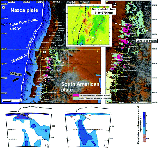
Recently released seismic tomography developed after the Maule earthquake has shed light on the sublithospheric structure of the Southern Volcanic Zone where Copahue volcano is located (Fig. ). Thus a change in subduction geometry would have been achieved in the last 53 Ma between 37 and 39S from a steeper configuration to a shallower one.
Fig. 1.1
a b Pliocene-Early Pleistocene and Pleistocene-Holocene arc activity in the Main Andes between 3739S (Lara et al. ). The Copahue Volcano is indicated with a triangle in yellow. Note that, as depicted in B, arc volcanoes with Holocene activity between 37 and 41S are mainly emplaced on the western Andean slope, in comparison with late Pliocene to early Pleistocene centers developed on both sides of the Andes (see text for further details)
This important change has a correlation with the pattern of arc activity between 36 and 40S. Lara et al. ().
This westward retraction was accompanied by within-plate volcanism in the Loncopu extensional trough in the last 2 Ma (Rojas Vera et al. ).
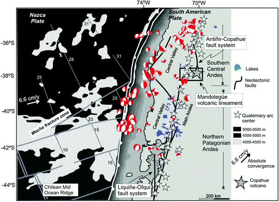
Shallow structure through this segment is characterized by two distinctive systems: (i) Along the arc front, the Liquie-Ofqui fault system accommodates lateral displacements imposed by the oblique convergence between the Nazca and South American plates (Lavenu and Cembrano ).
Fig. 1.2
Tectonic framework of the Southern Volcanic Zone (modified from Herv ). Note the location of the Mandolege volcanic lineament in the site where the Copahue Volcano is hosted at the northern termination of the strike-slip Liquie-Ofqui fault zone and the transition to the Antiir-Copahue fault system. Note also that the Mandolege volcanic lineament coincides with the site of inception of the oceanic Mocha transform zone and associated plateau into the Chilean trench
Fig. 1.3
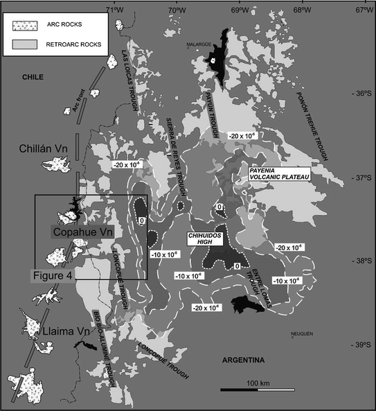
Attenuated crust at the retroarc zone determined from a receiver function profile at 39S (Yuan et al. ). Gravimetric values are in mGals
This crustal attenuation and associated retroarc magmatism have been explained by steepening of the Nazca plate during westward arc retraction about 52 Ma and consequent injection of hot asthenospheric material, after a period (135 Ma) of shallow subduction in the area (Kay et al. ).
1.2.1 The Mandolege Volcanic Lineament
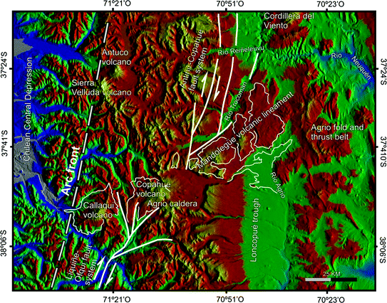
This 6070-km-long volcanic lineament is formed by the partial amalgamation of seven main volcanic centers, which from west to east, are the Callaqui Volcano, Copahue Volcano, Las Mellizas volcanic center, Troln Volcano, Bayo Dome, and Huec and Mandolege monogenetic basaltic fields (Figs. ).
Fig. 1.4
Digital Elevation Model that shows the surficial expression of the Callaqui-Copahue-Mandolege volcanic lineament interposed between the Liquie-Ofqui and the Callaqui-Mandolege fault systems
