Molloy - Hiking through history: New England: exploring the regions past by trail
Here you can read online Molloy - Hiking through history: New England: exploring the regions past by trail full text of the book (entire story) in english for free. Download pdf and epub, get meaning, cover and reviews about this ebook. City: New England, year: 2015, publisher: Falcon Guides, genre: Romance novel. Description of the work, (preface) as well as reviews are available. Best literature library LitArk.com created for fans of good reading and offers a wide selection of genres:
Romance novel
Science fiction
Adventure
Detective
Science
History
Home and family
Prose
Art
Politics
Computer
Non-fiction
Religion
Business
Children
Humor
Choose a favorite category and find really read worthwhile books. Enjoy immersion in the world of imagination, feel the emotions of the characters or learn something new for yourself, make an fascinating discovery.

- Book:Hiking through history: New England: exploring the regions past by trail
- Author:
- Publisher:Falcon Guides
- Genre:
- Year:2015
- City:New England
- Rating:4 / 5
- Favourites:Add to favourites
- Your mark:
Hiking through history: New England: exploring the regions past by trail: summary, description and annotation
We offer to read an annotation, description, summary or preface (depends on what the author of the book "Hiking through history: New England: exploring the regions past by trail" wrote himself). If you haven't found the necessary information about the book — write in the comments, we will try to find it.
Molloy: author's other books
Who wrote Hiking through history: New England: exploring the regions past by trail? Find out the surname, the name of the author of the book and a list of all author's works by series.


Hiking through history: New England: exploring the regions past by trail — read online for free the complete book (whole text) full work
Below is the text of the book, divided by pages. System saving the place of the last page read, allows you to conveniently read the book "Hiking through history: New England: exploring the regions past by trail" online for free, without having to search again every time where you left off. Put a bookmark, and you can go to the page where you finished reading at any time.
Font size:
Interval:
Bookmark:
Johnny Molloy is a writer and adventurer who has penned over fifty outdoor hiking, camping, and paddling guides, as well as true outdoor adventure stories. His nonfiction passion started after reading In Cold Blood by Truman Capote, which his father had left lying around. After that, he delved into all manner of nonfiction reading, from Strange But True Football Stories to books about the Mississippi River, Lewis and Clark, and the Civil War. He has since focused his reading on early American history.
His outdoor passion started on a backpacking trip in Great Smoky Mountains National Park while attending the University of Tennessee. That first foray unleashed a love of the outdoors that has led Molloy to spend most of his time hiking, backpacking, canoe camping, and tent camping for the past three decades. Friends enjoyed his outdoor adventure stories, and one even suggested he write a book. He pursued his friends idea and soon parlayed his love of the outdoors into an occupation.
Molloy writes for various magazines, websites, and newspapers. He continues writing and traveling extensively throughout the United States, engaging in a variety of outdoor pursuits. His non-outdoor interests include serving God as a Gideon and University of Tennessee sports. For the latest on Johnny, visit johnnymolloy.com.
Thanks to all the people who preserved history before we ever got here. Thanks to DeLorme for the fine GPS that helped create the maps for this book. Thanks to Kelty for providing me with great tents, sleeping bags, and clothing for the outdoors. Thanks also to the folks at FalconGuides, especially that Connecticuter Katie Benoit. Thanks to Scott and Rina Grierson for their Maine hospitality, to Eric and Sally Mullins for making us feel at home, and to Ken Ashley and Anne Leeds for their friendship. And thanks to Eve Sherwood for holding down the fort.

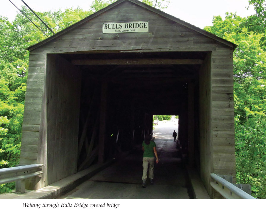
This hike treks along the wild Housatonic River, first spanning it via a historic covered bridge. Next join the Appalachian Trail, wandering by whitewater rapids amid former farmland, replete with stone fences. The hike then stops by an AT shelter, where old agricultural implements can be found. Leave the enticing water and then climb to Ten Mile Hill for a view. A mini-loop at hikes end leads by old chimneys from a forgotten homesite.
Start: Bulls Bridge parking area
Distance: 4.7 miles out and back with a mini-loop on return
Hiking time: 33.5 hours
Difficulty: Moderate due to 700-foot climb
Trail surface: Natural
Best season: Summer for aquatic fun
Other trail users: None
Canine compatibility: Dogs allowed
Land status: First Light Power Generating Company, National Park Service
Fees and permits: No fees or permits required
Schedule: Open 24 hours a day year-round; no trailhead parking allowed between sunset and sunrise
Maps: Appalachian Trail, Kent to CT 55 section
Trail contact: National Park Service, Appalachian Trail Park Office, PO Box 50, Harpers Ferry, WV 25425; (304) 535-6278; nps.gov/appa
Finding the trailhead: From the intersection of CT 7 and US 202 in New Milford, Connecticut, take CT 7 north 9 miles to the hamlet of Bulls Bridge. Turn left onto Bulls Bridge Road at a traffic light and follow it just a few feet; turn left into a parking area just before driving through Bulls Bridge. Trailhead GPS: N41 40.539' / W73 30.494'
The Hike
The community of Bulls Bridge, in western Connecticut near the New York border, is named for the covered bridge located here. The one-lane bridge, part of this hike, spans a channel of the Housatonic River. As we all know, George Washington got around in his day, and it is said that the general lost his favored horse while crossing the Housatonic at the bridge site and had to pay a hefty bill of $212 to get it retrieved from the rapids. The 109-foot covered bridge was built in 1842, long after Washingtons day.
Enjoy both human history and natural beauty on this trek. After crossing the power generation canal dug by First Light Power Generating Company, you stroll through Bulls Bridge, which is open to cars but regularly walked through by tourists and hikers alike. In fact, to get from the trailhead parking to the trail itself, you must hike through the dim wooden structure rising above frothing torrents of the Housatonic River. Ahead, trails spur off, including a portage trail whereby Housatonic paddlers tote their boats around the power station. On your way to the AT connector trail, look for the short loop path leading to an overlook of the convergence of two channels of the Housatonic. Observe the whitewater extravaganza as daring boaters ply their craft, while others head for riverside rocks to fish or soak in the atmosphere. No swimming is allowed hereabouts.
You then pick up a connector to meet the Appalachian Trail. Your southbound hike leads along the Housatonic River gorge, an impressive mix of motionless stone and frenetic aqua. See more watery wonders in the form of Ten Mile River, which you cross on an impressive iron span. The sandy confluence of the Ten Mile and Housatonic Rivers beckons you to linger. AT thru-hikers camp here and at the nearby Ten Mile trail shelter. The structure faces a field and offers a perspective of what this area looked like before reforestation shaded the amazing number of stone fencelined fields. Scan for old farm implements near the shelter, further evidence of a previously peopled past.
The first section of the Appalachian Trail in Connecticut was constructed in 1930 by Ned Anderson. He and his Boy Scout troop maintained the Connecticut AT for the next eighteen years.
After exploring the shelter/camping area, continue on the Appalachian Trail to the crest of Ten Mile Hill. En route, the path leads through deep towering hardwoods shading a mossy, ferny, and stony forest floor. Switchbacks ease the climb. A short spur at the top of the 1,000-foot peak leads to a stone outcrop amid sturdy oaks and hickories. Here, peer northwest into the Ten Mile River valley and the state of New York. From this vantage, make the descent back to the HousatonicTen Mile River confluence, crossing the iron span again. This time, an alternate loop leads up a low hill on a time-worn farm road. Here, more stone fences appear; a keen eye will spot a pair of standing chimneys, one brick and one stone, all that remains of a Housatonic valley farm. Before reaching the trailhead, you get one more chance to walk through Bulls Bridge, with its undersize windows letting in just enough light for you to make your way.
Miles and Directions
| 0.0 | Start from the Bulls Bridge parking area and walk east on Bulls Bridge Road. Cross an outflow canal of the power plant, visible just upstream. Dip to enter historic Bulls Bridge covered bridge. Watch for cars. Beyond Bulls Bridge, trails lead right, but stay with Bulls Bridge Road, coming to a gated parking area. ( |
Font size:
Interval:
Bookmark:
Similar books «Hiking through history: New England: exploring the regions past by trail»
Look at similar books to Hiking through history: New England: exploring the regions past by trail. We have selected literature similar in name and meaning in the hope of providing readers with more options to find new, interesting, not yet read works.
Discussion, reviews of the book Hiking through history: New England: exploring the regions past by trail and just readers' own opinions. Leave your comments, write what you think about the work, its meaning or the main characters. Specify what exactly you liked and what you didn't like, and why you think so.