FOREWORD
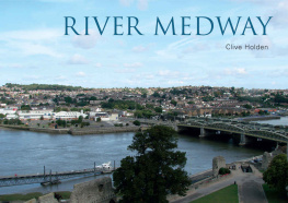
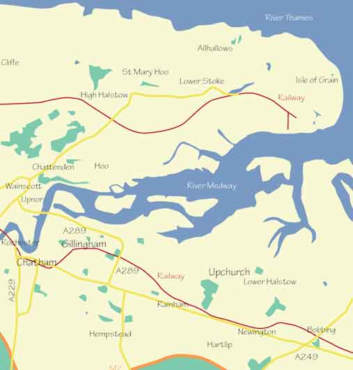
In this book I take the reader on a journey up one of Britains greatest rivers, from its mouth on the Thames Estuary to its source deep in a wood in the middle of Sussex. On the route upriver we pass by the large urban sprawls of the Medway Towns, the historic towns of Maidstone and Tonbridge and the beautiful countryside of the High Weald. Along the way I explain some of the history of the places we pass, the environment and wildlife, the opportunities for leisure activities and feature some nearby places of interest.
The River Medway changes direction a number of times along its course and so in navigating the reader along the route Ive followed the rules of boating, which designate the right and left banks of a river as though travelling from the source down river, whether you are navigating up river or down. Thus, as our journey takes us upriver, where I describe somewhere as being on the right bank of the river it will actually be on our left-hand side.
I would like to thank the following for their help and kindness in assisting me with the compilation of this book: John Vaughan, Tony Grant, Ian Yarham and David Anstiss.
Clive Holden
February 2015
First published 2015
Amberley Publishing
The Hill, Stroud, Gloucestershire, GL5 4EP
www.amberley-books.com
Copyright Clive Holden, 2015
The right of Clive Holden to be identified as the Author of this work has been asserted in accordance with the Copyrights, Designs and Patents Act 1988.
ISBN 9781445637921 (PRINT)
ISBN 9781445638034 (eBOOK)
All rights reserved. No part of this book may be reprinted or reproduced or utilised in any form or by any electronic, mechanical or other means, now known or hereafter invented, including photocopying and recording, or in any information storage or retrieval system, without the permission in writing from the Publishers.
British Library Cataloguing in Publication Data.
A catalogue record for this book is available from the British Library.
Typesetting by Amberley Publishing.
Printed in Great Britain.
CONTENTS
INTRODUCTION
The River Medway runs for almost 70 miles from its source near Turners Hill in West Sussex through Kent, entering the Thames Estuary between the Isles of Grain and Sheppey. It has a catchment area of 930 square miles, the largest of any river in England, and its extensive network of tributaries include the rivers Eden, Teise, Bourne, Len and Beult. The river remains tidal from Sheerness to Allington Lock near Maidstone.
From Sheerness, the journey upriver passes the Hoo Peninsula on one side and the Medway towns of Rainham, Gillingham, Chatham and the city of Rochester on the other. Then, it carries on through the heart of the old Medway cement industry belt until it reaches its first lock at Allington. From here it remains navigable until it reaches the Leigh Barrier, just south of Tonbridge. This latter 19-mile stretch of the river is known as the Medway Navigation. The Environment Agency is the authority responsible for the navigation.
The upper reaches of the river pass on through Kent into the High Weald of Sussex, past the sites of the watermills and iron works that once stood by its banks, to its source deep in a wood in West Sussex.
The Medway has a rich and fascinating history. Early Bronze Age stone implements, including a narrow ground flint chisel and a partly polished ground flint axe, were found during the work on the extension of Chatham Dockyard in 1871. The first recorded maritime visitors to sail up the river were the Phoenicians, an ancient Semitic civilization who existed between 1200 and 300 BC and was centred on the coastline of modern Lebanon. Phoenician artefacts have been discovered on the Hoo Peninsula. Ancient Greek merchants also traded up the Medway, and at St Marys church on the river at Chatham a Greek stone tablet was discovered built into the Norman wall of a chapel that once stood on the site. The tablet can now be found built into the porch of the later church.
Romans, Jutes, Angles and Saxons all fought against local tribes along the river, which formed a natural barrier against these early marauding invaders. It was the Romans that established the first major crossing and settlement on the river at Rochester.
The Medways strategic importance increased with the establishment of Chatham Dockyard in the sixteenth century. In 1667, the Dutch fleet sailed up the river and attacked the English ships at anchor, the result of which was the considerable strengthening of the rivers defences. In later centuries, the French and then the Germans were the major threats, and in the Second World War the whole area around the Medway Towns teemed with garrisons, forts, depots and gun batteries. The length of the river was dotted with pillboxes and trench systems as part of General Ironsides GHQ Line, a series of stop-lines constructed to defend the approaches to London from any German invasion force.
Fishing has always been an important part of life along the river. Laws to control fishing in the Medway probably go back at least to Norman times. The earliest documentary evidence of the rules and regulations dates to 1446 in the form of a Royal Charter issued in the name of Henry VI granting rights to the citizens of Rochester to all fishing between Sheerness and Hawkwood, near Burham. London fishermen were also allowed to catch only certain kinds of fish from waters near the north bank of the Medway as far upriver as Lower Upnor. The river was abundant in oysters and these continued to be a major part of the fishing industry, until the twentieth century when their numbers steadily declined through pollution and disease. The final straw was the terrible winter of 1939/40 that killed off all the remaining oyster stocks in the Lower Medway.
The River Medway and its estuary form a complicated ecosystem with a wide range of different habitats. In the estuary these include intertidal mudflats, salt marsh, grazing marsh and sea walls. Further upriver there are many areas designated to be of Special Scientific Interest such as the Holborough Marshes, the country park at Rainham and the nature reserve at Cuxton.
The river played a major role in industrial growth during the nineteenth and twentieth centuries, with many wharves, warehouses, factories, cement works, quarries, paper mills and breweries dotted along its route. Most of these have now long disappeared and this, along with the closure of Chatham Dockyard in 1984, means that heavy industry no longer plays such a significant part in life and work along the river. Many of the old industrial sites have been replaced with housing, retail parks, trading estates and leisure facilities offering many new but different opportunities for employment. This regeneration has been a long process and is still ongoing, but the fruits of it can now be seen along the length of a river which, together with its beautiful rural upper reaches, still plays such an important part in so many peoples lives.
1
SHEERNESS TO ROCHESTER
The entrance of the Medway from the Thames Estuary lies between the Isle of Grain and the Isle of Sheppey. The whole Medway Estuary has protection as part of the Medway Estuary and Marshes Site of Scientific Interest, Special Protection Area. It also has protection under the Ramsar Convention on Wetlands, an inter-government treaty that provides the framework for national action and international cooperation for the conservation of wetlands and their resources. It is a very important habitat for wintering ducks and waders, which thrive on the invertebrate-rich mudflats that abound here.

