Appendix A
Driving Tour: The Retreat from Gettysburg
A NOTE OF EXPLANATION IS NECESSARY before beginning this driving tour. The first half of the tour covers events chronologically; the second half of the tour does not. Covering that part of the tour in the correct chronological order would require a great deal of doubling back and nearly twice as much driving. Accordingly, the second half proceeds geographically instead. For instance, the July 7 fight at Boonsboro comes after the July 10 fight at Funkstown, and the July 6 fight at Williamsport appears at the end of the tour. The tour of the route of the Confederate Wagon Train of Wounded that follows, however, does proceed chronologically. We suggest that you try to allow a full day for each tour to fully enjoy the sites of interest.
Beginning at the Taneytown Road entrance to the National Cemetery in Gettysburg, this driving tour of the route of the main retreat column covers 64.8 miles. The optional side trips to Bunker Hill and the West Virginia side of Falling Waters add another 49.1 miles to the trip. Set your odometers mileage to 0.0 when at the Cemetery Entrance . Eleven times along the tour you will reset your mileage to 0.0 before continuing, to help keep you on track. This will allow for differences in odometers and different parking locations at rest stops and the suggested stops enroute
Please watch for road signs and historical landmarks along the route, and be very aware of traffic. Respect private property and please do not trespass. To assist you with both tours and add to your enjoyment, we have also recorded the Global Positioning System (GPS) coordinates for the key points along the routes. These are listed in the driving directions as Retreat Waypoint (RW) 1 through 74 in this tour, and as Wagon Train Waypoint (WTW) 1 through 35 in the second tour. In addition to being included with each stop, the coordinates for the waypoints are also listed at the end of each tour should you wish to program them into your GPS unit ahead of time.

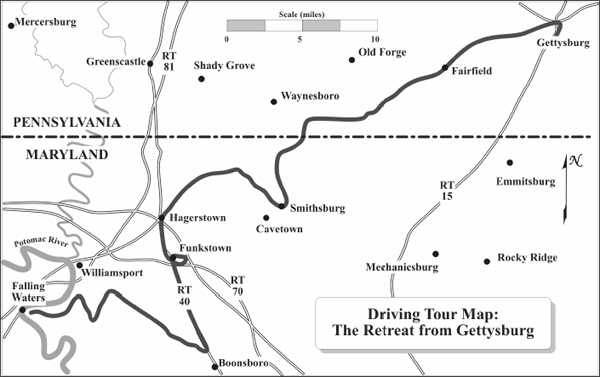
Begin the tour in Gettysburg, Pennsylvania at the Taneytown Road entrance to the National Cemetery, facing north toward town (the Cemetery entrance will be on your right). Set your odometer to 0.0.
RW 1 (N 39 49.057 W 077 13.949) Proceed north on the Taneytown Road toward town.
RW 2 (N 39 49.273 W 077 13.997) After .2 miles, you will reach the traffic light at Steinwehr Avenue. Continue straight through the traffic light and proceed onto Washington Street .
RW 3 (N 39 49.784 W 077 14.007) After .6 miles, turn left at the traffic light onto Middle Street .
RW 4 (N 39 49.786 W 077 14.643) After .6 miles at the traffic light, note West Confederate Avenue to your left, and Seminary Road to your right . This is Seminary Ridge, the Confederate line of battle. The retreat of the Army of Northern Virginia began from this point. Continue straight through the traffic light . Middle Street now becomes the Fairfield Road (Route 116), and you will pass by a portion of the first days battlefield. (Do not follow the National Park Service Auto Tour sign onto Reynolds Avenue.)
RW 5 (N 39 49.112 W 077 17.037) In 2.2 miles, you will come to Black Horse Tavern Road (there are roadside tablets on the right, in front of the war-time building). The Black Horse Tavern served as a Confederate Field Hospital. It also served as a huge wagon park for the Confederate trains, and many of them began their retreat journey here. During the retreat, General Robert E. Lee stopped here to watch his troops begin their arduous journey home. The property is privately owned, so please do not trespass. To your rear you will see Breams Hill Road. This is the original road trace of the Fairfield Road.
RW 6 (N 39 48.628 W 077 19.276) After another 2.2 miles, you will see the Lower Marsh Creek Church on the right . Confederate Lieutenant General Richard S. Ewells Second Corps trains extended from here back to the Black Horse Tavern. Many of the period buildings along this route were used as temporary field hospitals. Badly wounded men were removed from the wagons as needed, and left to recuperate at local homes. Many dead were buried alongside the road. Continuing .6 miles beyond the church you will see the Granite Hill Campground which marks the vicinity of the first skirmish during the retreat between the Confederate rear guard and pursuing elements of the Union 6th Corps.
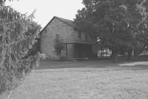
Black Horse Tavern.
Authors Photo
RW 7 (N 39 47.500 W 077 21.825) After 2.6 miles from the church, you will see Carolls Tract Road on your right (known during the war as the Fairfield-Ortanna Road). On the afternoon of July 3rd, 1863, the 6th US Cavalry fought a pitched battle against Confederate Brigadier General William E. Grumble Jones cavalry brigade along the Fairfield-Ortanna Road, 2.5 miles north of this intersection. During the retreat, Confederate trains moving south from Cashtown along joined the main retreat route here. The resulting traffic jam caused Confederate General Jubal Earlys troops to unlimber an artillery piece nearby and fire (firing powder only with no projectiles) toward their own trains to spur them along. Do not turn, but continue straight and you will enter the town of Fairfield, Pennsylvania.
RW 8 (N 39 46.866 W 077 22.694) After 1.25 miles, turn right onto Iron Springs Road . The hill ahead on your left is Jacks Mountain. The narrow Fairfield Gap is immediately to its right. The fields to the left were the location of Heths Divisions camps on June 30th. The June 30th skirmish between elements of the 8th Illinois Cavalry and two regiments of Southern infantry occurred near here at the base of the Fairfield Gap. You will pass through the Fairfield Gap as you proceed. The stream flowing along either side of the road here is Toms Creek. The Tapeworm Railroad, dating from 1834, will be visible on your right. The railroad will cross the route several times as you travel through the pass. You will note that the pass is very narrow as the road winds to the summit (please drive with caution). Lee barricaded the Gap until July 7 in an attempt to prevent the Federals from pursuing his army into the mountains.
RW 9 (N 39 46.017 W 077 25.998) 3.35 miles along Iron Springs Road, you will see Gum Springs Road on your right . While the Infantry continued along Iron Springs Road, the Confederate trains turned onto Gum Springs Road in the driving rainstorm and then traveled down Mariah Furnace Road (only a trace of which remains in thick woods today). From here you are beginning to ascend South Mountain. Do not turn, but continue on Iron Springs Road through the hamlet of Greenstone.
RW 10 (N 39 44.708 W 077 27.209) After 2.1 miles, turn right onto Old Waynesboro Road . Across from the intersection is a roadside marker addressing the Battle of Fountain Dale. Brigadier General Judson Kilpatricks Federal cavalry division, plus the brigade of Colonel Pennock Huey, had come up from Emmitsburg, Maryland during the evening of July 4, 1863. The troopers used the Waynesboro Turnpike (as it was known) as their route of march, and you are now following in their steps. As Kilpatricks division proceeded, Colonel Peter Staggs 1st Michigan Cavalry charged up Iron Springs Road before being repulsed by Confederate cavalry of the brigades of Brigadier Generals William E. Grumble Jones and Beverly H. Robertson. Captain George M. Emack of the 1st Maryland Cavalry (CSA) held off Kilpatricks cavalry with a single company of about 50 men and one artillery piece. Initially this gun was positioned where the road intersects with the current-day entrance to the Greenstone plant. In 1863, this was a narrow one-lane road with sheer drop offs on the left side.

