Motomaro Shirao - The Kaguya Lunar Atlas
Here you can read online Motomaro Shirao - The Kaguya Lunar Atlas full text of the book (entire story) in english for free. Download pdf and epub, get meaning, cover and reviews about this ebook. City: New York, publisher: Springer, genre: Children. Description of the work, (preface) as well as reviews are available. Best literature library LitArk.com created for fans of good reading and offers a wide selection of genres:
Romance novel
Science fiction
Adventure
Detective
Science
History
Home and family
Prose
Art
Politics
Computer
Non-fiction
Religion
Business
Children
Humor
Choose a favorite category and find really read worthwhile books. Enjoy immersion in the world of imagination, feel the emotions of the characters or learn something new for yourself, make an fascinating discovery.

- Book:The Kaguya Lunar Atlas
- Author:
- Publisher:Springer
- Genre:
- City:New York
- Rating:5 / 5
- Favourites:Add to favourites
- Your mark:
The Kaguya Lunar Atlas: summary, description and annotation
We offer to read an annotation, description, summary or preface (depends on what the author of the book "The Kaguya Lunar Atlas" wrote himself). If you haven't found the necessary information about the book — write in the comments, we will try to find it.
Motomaro Shirao: author's other books
Who wrote The Kaguya Lunar Atlas? Find out the surname, the name of the author of the book and a list of all author's works by series.


The Kaguya Lunar Atlas — read online for free the complete book (whole text) full work
Below is the text of the book, divided by pages. System saving the place of the last page read, allows you to conveniently read the book "The Kaguya Lunar Atlas" online for free, without having to search again every time where you left off. Put a bookmark, and you can go to the page where you finished reading at any time.
Font size:
Interval:
Bookmark:
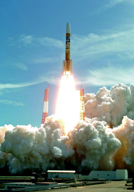
Background
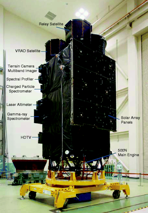
Mission instruments | Purpose |
|---|---|
X-ray Spectrometer (XRS) | The surface elemental composition (Al, Si, Mg, Fe, etc.) is determined through X-ray fluorescence spectrometry by irradiation of solar X-ray |
Gamma-ray Spectrometer (GRS) | The abundance of key elements (U, Th, K, H, etc.) is determined by measuring energy spectra of gamma-rays from the lunar surface with high energy resolution |
Multiband Imager (MI) | The mineral distribution is derived from visible and near infrared images of the Moons surface taken in nine wavelength bands |
Spectral Profiler (SP) | The mineral composition of the Moons surface is obtained by measuring the continuous visible and near infrared spectrum |
Terrain Camera (TC) | High-resolution geographical features are acquired by the stereo cameras |
Lunar Radar Sounder (LRS) | The subsurface stratification and tectonic features in the shallow part of the lunar crust (a few kilometers) by high-power RF pulses |
Laser Altimeter (LALT) | Surface altitudes are precisely measured using high-power laser pulses to make a lunar topography model |
Lunar Magnetometer (LMAG) | The magnetization structure on the Moon is acquired by measuring the lunar and the surrounding magnetic field |
Charged Particle Spectrometer (CPS) | Alpha rays from the Moons surface and the abundance of cosmic ray particles are measured |
Plasma Energy Angle and Composition Experiment (PACE) | The three dimensional distribution of the low-energy electrons and mass-discriminated low-energy ions around the Moon are measured |
Radio Science (RS) | The Moons ionosphere is detected by measuring the small deviation in the phase of RF signals from OUNA (VRAD Satellite) |
Upper atmosphere and Plasma Imager (UPI) | Images of the magnetosphere and the ionosphere around the Earth as seen from the Moon are used to study the behavior of the plasma |
Four-way Doppler measurements by OKINA (Relay Satellite) and main orbiter transponder (RSAT) | Signals from the Main Orbiter in flight on the far side of the Moon are relayed by OKINA (Relay Satellite), and the local gravity field data from the far side of the Moon is obtained by measuring the disturbance in the orbit of the Main orbiter using four-way Doppler measurements |
Differential VLBI radio source (VRAD) | The gravity field of the Moon is accurately observed by measuring the orbits of the OKINA (Relay Satellite) and OUNA (VRAD Satellite) using differential VLBI: (Very Long Baseline Interferometry) |
High-Definition Television (HDTV) | Taking pictures and movies of the Earth and the Moon with high-definition television cameras |
Font size:
Interval:
Bookmark:
Similar books «The Kaguya Lunar Atlas»
Look at similar books to The Kaguya Lunar Atlas. We have selected literature similar in name and meaning in the hope of providing readers with more options to find new, interesting, not yet read works.
Discussion, reviews of the book The Kaguya Lunar Atlas and just readers' own opinions. Leave your comments, write what you think about the work, its meaning or the main characters. Specify what exactly you liked and what you didn't like, and why you think so.