Your Guide to Congaree National Park, First Edition (electronic)
ISBN: 978-1-62128-006-4
Published by: Stone Road Press
Author/Cartographer/Photographer/Designer: Michael Joseph Oswald
Editor: Derek Pankratz
Copyright 2012 Stone Road Press, LLC, Whitelaw, Wisconsin. All rights reserved. No part of this publication may be reproduced, stored in a retrieval system or transmitted in any form or by any means, electronic, mechanical, photocopying, recording, scanning or otherwise without written permission of the Publisher. Requests for permission should be addressed to Stone Road Press; c/o Michael Oswald; 4927 Stone Road; Whitelaw, WI 54247.
The entire work, Your Guide to the National Parks is available in paperback and electronic versions. Content that appears in print may not be available electronically.
Paperback ISBN: 978-1-62128-000-2
Library of Congress Control Number (LCCN): 2012934277
Printed in the United States of America
E-Book ISBN: 978-1-62128-065-1
Corrections/Contact
This guide book has been researched and written with the greatest attention to detail in order to provide you with the most accurate and pertinent information. Unfortunately, travel informationespecially pricingis subject to change and inadvertent errors and omissions do occur. Should you encounter a change, error, or omission while using this guide book, wed like to hear about it. (If you found a wonderful place, trail, or activity not mentioned, wed love to hear about that too.) Please contact us by sending an e-mail to . Your contributions will help make future editions better than the last.
You can contact us online at www.StoneRoadPress.com or follow us on
Facebook: www.facebook.com/thestoneroadpress
Twitter: www.twitter.com/stoneroadpress (@stoneroadpress)
Flickr: www.flickr.com/photos/stoneroadpress
FAQs
The world of electronic media is not cut and dry like print. Devices handle files differently. Users have a variety of expectations. These e-books are image- and map-intensive, requiring fairly powerful hardware. All books were tested for use on the Kindle Fire, Nook Tablet, and iPad. You can expect to have the best user experience on one of these devices, or a similar tablet, laptop, or desktop. In the event you have issues please peruse our Frequently Asked Questions (.
Maps
Numerous map layouts were explored while developing this e-book, but in the end it was decided that the most useful map is a complete one. Unfortunately, due to file size concerns and e-reader hardware limitations, some maps included in this guide book are below our usual high standards of quality (even using zoom features). As a workaround all of this books maps are available in pdf format by clicking the link below each map or visiting www.stoneroadpress.com/national-parks/maps .
Disclaimer
Your safety is important to us. If any activity is beyond your ability or threatened by forces outside your control, do not attempt it. The maps in this book, although accurate and to scale, are not intended for hiking. Serious hikers should purchase a detailed, waterproof, topographical map. It is also suggested that you write or call in advance to confirm information when it matters most.
The primary purpose of this guide book is to enhance our readers national park experiences, but the author, editor, and publisher cannot be held responsible for any experiences while traveling.
Photo Credits
Front cover: Cottonmouth NPS
Congaree - Introduction
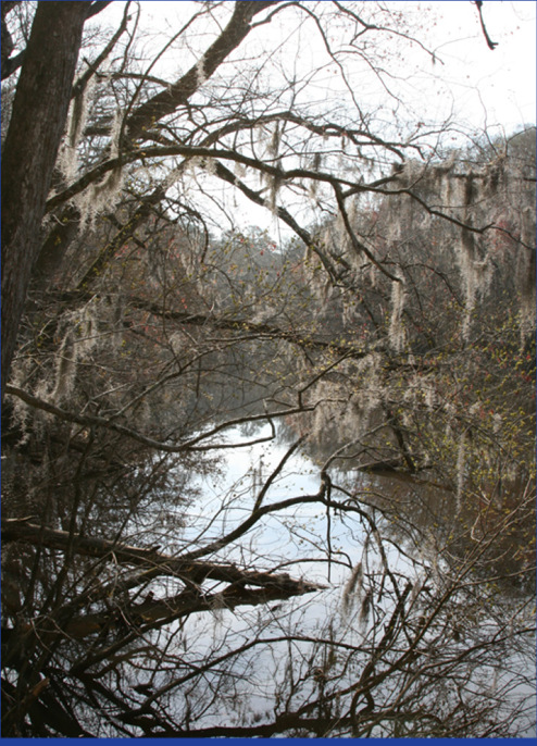
Spanish moss hanging from trees at Weston Lake
Congaree is akin to a rarely visited, scaled down combination of Redwood and Everglades National Parks. It protects the largest contiguous expanse of old growth bottomland hardwood forest left in the United States. Youll never confuse the towering bald cypress and loblolly pine for their West Coast rivals, the redwood and giant sequoia, but they are massive by East Coast standards. Several national and state champion trees reside within the parks boundary. Congarees canopy averages an impressive 130-feet, making it as tall as any temperate deciduous forest in the world. When navigable, Cedar Creek provides a narrow, maze-like waterway reminiscent of the Everglades River of Grass (minus the grass and throw in some moss). Trees and waterways provide habitat for a multitude of plants and animals. In fact, the park was recognized as an International Biosphere Reserve in 1983, and was designated a Globally Important Bird Area in 2001. A floodplain forest draped with Spanish moss, and the natural tranquility and wildness, give the illusion of traveling back in time to a primeval forest. These waterways and trees have helped shape the history of not only a park, but the entire region. Water protected and nourished trees. Trees attracted conservationists. And now this unique environment is protected and preserved for future generations to enjoy.
Hernando de Soto was first to detail an encounter with Congaree Indians in 1540. His exploration continued north through Appalachia, but natives stayed, living along what is now named the Congaree River. Around the turn of the 18th century, Congaree Indians were decimated by smallpox brought by European explorers. By 1715, the tribe consisted of 22 men and 70 women and children. Today they are gone but not forgotten; a river and park bear the name of the areas original inhabitants.
Frequent flooding rapidly renewed the soils nutrients, enabling trees to thrive and reach record heights. Surprisingly, floods werent beneficial to area farmers. Decades were spent trying to coax crops from the nutrient-rich land, but standing water stifled most agricultural activities. Farmers moved out of the floodplain, and Santee River Cypress Logging Company moved in. They purchased an exceptional tract of hardwood along the Congaree River in 1905, but regular flooding proved to be as troublesome to loggers as it was to farmers. Heavy logging equipment couldnt be moved across the wet and muddy earth. They could only access trees along the waterways where another problem aroseactually they sank, many of these trees were too green to float. Some remain to this day in the places they fell along the riverbank. After ten years of logging, the floodplain was left relatively unscathed. In 1969, high timber prices and advancements in logging equipment brought attention back to the uncut lumber of the Congaree River. This time floodwaters wouldnt be enough to save the trees. Thankfully, the Sierra Club stepped in. Their grassroots campaign to save the trees culminated in establishment of Congaree Swamp National Monument in 1976. Incorrectly labeled a swamp, the area does not contain standing water throughout most of the year, so its actually a floodplain. Regardless, new legislation protected this land, its trees, and its waterways from future human exploitation.
Nothing could protect the monument from Hurricane Hugo . In 1989 winds whipped through the forests, toppling many champion trees and permanently changing the parks landscape. But with tragedy came new life and diversity. Sunlight could once again penetrate the canopy. Nature ran its course, and new growth sprang up across the floodplain. Downed trees became habitat for plants and animals. Land unsuitable for farming and logging proved to be suitable for life. A flourishing ecosystem for bobcat, white-tailed deer, river otter, snakes and insects, fungi and ferns, is on display at Congaree National Park.
Biking (CONG)
Bicycles are allowed in the park but all trails, including The Boardwalk, are closed to cyclists. That leaves the 1.5-mile National Park Road as the lone stretch of pavement for bikers. A few roads surrounding the park offer decent, flat pedalling, but its not really worth the effort of bringing a bike to Congaree.
Next page
