Your Guide to Shenandoah National Park, First Edition (electronic)
ISBN: 978-1-62128-003-3
Published by: Stone Road Press
Author/Cartographer/Photographer/Designer: Michael Joseph Oswald
Editor: Derek Pankratz
Copyright 2012 Stone Road Press, LLC, Whitelaw, Wisconsin. All rights reserved. No part of this publication may be reproduced, stored in a retrieval system or transmitted in any form or by any means, electronic, mechanical, photocopying, recording, scanning or otherwise without written permission of the Publisher. Requests for permission should be addressed to Stone Road Press; c/o Michael Oswald; 4927 Stone Road; Whitelaw, WI 54247.
The entire work, Your Guide to the National Parks is available in paperback and electronic versions. Content that appears in print may not be available electronically.
Paperback ISBN: 978-1-62128-000-2
Library of Congress Control Number (LCCN): 2012934277
Printed in the United States of America
E-Book ISBN: 978-1-62128-0 65-1
Corrections/Contact
This guide book has been researched and written with the greatest attention to detail in order to provide you with the most accurate and pertinent information. Unfortunately, travel informationespecially pricingis subject to change and inadvertent errors and omissions do occur. Should you encounter a change, error, or omission while using this guide book, wed like to hear about it. (If you found a wonderful place, trail, or activity not mentioned, wed love to hear about that too.) Please contact us by sending an e-mail to . Your contributions will help make future editions better than the last.
You can contact us online at www.StoneRoadPress.com or follow us on
Facebook: www.facebook.com/thestoneroadpress
Twitter: www.twitter.com/stoneroadpress (@stoneroadpress)
Flickr: www.flickr.com/photos/stoneroadpress
FAQs
The world of electronic media is not cut and dry like print. Devices handle files differently. Users have a variety of expectations. These e-books are image- and map-intensive, requiring fairly powerful hardware. All books were tested for use on the Kindle Fire, Nook Tablet, and iPad. You can expect to have the best user experience on one of these devices, or a similar tablet, laptop, or desktop. In the event you have issues please peruse our Frequently Asked Questions (.
Maps
Numerous map layouts were explored while developing this e-book, but in the end it was decided that the most useful map is a complete one. Unfortunately, due to file size concerns and e-reader hardware limitations, some maps included in this guide book are below our usual high standards of quality (even using zoom features). As a workaround all of this books maps are available in pdf format by clicking the link below each map or visiting www.stoneroadpress.com/national-parks/maps .
Disclaimer
Your safety is important to us. If any activity is beyond your ability or threatened by forces outside your control, do not attempt it. The maps in this book, although accurate and to scale, are not intended for hiking. Serious hikers should purchase a detailed, waterproof, topographical map. It is also suggested that you write or call in advance to confirm information when it matters most.
The primary purpose of this guide book is to enhance our readers national park experiences, but the author, editor, and publisher cannot be held responsible for any experiences while traveling.
Photo Credits
Front cover: Under cover of fog NPS
Shenandoah - Introduction
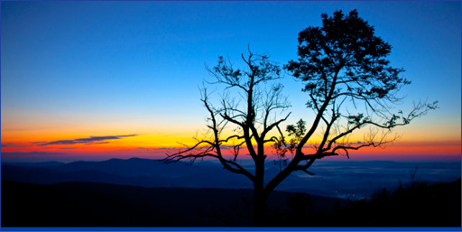
The sun rising up over the Virginia Piedmont Owen Byrne
Shenandoah National Park is centered on a long narrow stretch of the Blue Ridge Mountains . Forested mountaintops give way to the Shenandoah River Valley to the west and the gentle hills of the Virginia Piedmont to the east. The 105-mile Skyline Drive bisects the park as it follows the mountains crest. Located just 75 miles from the nations capital, it may come as no surprise that the formation of Shenandoah had as much to do with politics and personalities as with natural forces.
Long before it received federal government protection, the Shenandoah region served many purposes to many different people. Native Americans hunted and gathered for survival. Loggers and miners tapped the land for its resources. Union and Confederate soldiers shed blood deep in the Shenandoah Valley.
Eventually resorts began to crop up high atop the mountains, and for the past century Skyland Resort has served as recreational hub of Shenandoah. Ironically, Skyland never intended to be a company specializing in tourism. Between 1854 and 1866, a large tract of land within present park boundaries exchanged hands between numerous mining companies on speculation of substantial copper and iron deposits. Miners Lode Copper Company found the land to be commercially unsuccessful. However, George Freeman Pollock , son of one of the primary shareholders, convinced his father that the land had value as a resort. On October 1, 1889, Pollocks father and Stephen M. Allen formed the Blue Ridge Stonyman Park Preserve . Guests paid $9.50 per week to sleep in tents outfitted with cots, chairs, washstands, and pitchers. An idea far more prosperous than mines ever were, but not enough to cover debt owed on the lands initial purchase. Stonyman Preserve had to be put up for sale at public auction to satisfy the mortgage. George Freeman Pollock, jobless and unsure of his future, was allowed to buy the Blue Ridge land on credit. He renamed it Skyland Resort, but his attempts at business fared much like his fathers. He found himself in continuous debt, never actually gaining title to the land. Pollock may not have been much of a businessman, but he was a successful marketer. He threw elaborate balls, costume parties, jousts, musicals, pageants, and bonfires. His other skill was pandering to Washingtons politicians. He became one of the most influential local advocates for the construction of Skyline Drive and the formation of a national park, but at the time of the parks establishment in 1935, Pollock had $67,107 in outstanding liens against a property appraised at less than $30,000.
Growth and success of national parks in the west sparked Congress to commission the Southern Appalachian Committee to perform a thorough and wide-ranging survey of prospective locations in the east. The committees survey proposed that land of present day Mammoth Cave , Shenandoah , and the Great Smoky Mountains met the ideals of a U.S. National Park, and on February 25, 1924, Congress authorized establishment of Shenandoah National Park. Authorization was easy, but procuring land for the park proved challenging. More than 1,000 privately owned tracts had to be turned over to federal ownership, a drastic change compared to western parks where most land was already federally owned. The state of Virginia responded by acquiring 1,088 tracts of land through condemnation and eminent domain, then donating all of it to the federal government. Some 465 mountain residents moved or were forced to move, but a handful were allowed to live out their lives within the park. The last life-long resident, Annie Bradley Shenk, passed away in 1979 at the age of 92.
By the time the park was established, development was well underway thanks to the effort of George Freeman Pollock and President Roosevelts New Deal. Forty miles of Skyline Drive were already completed. Ten CCC camps, housing as many as 1,000 workers, were set-up. The CCC built trails and facilities around Skyland and Skyline Drive, which would become the primary attractions of a successful park that presently receives more than one million annual visitors.
Next page
