Your Guide to North Cascades National Park, First Edition (electronic)
ISBN: 978-1-62128-045-3
Published by: Stone Road Press
Author/Cartographer/Photographer/Designer: Michael Joseph Oswald
Editor: Derek Pankratz
Copyright 2012 Stone Road Press, LLC, Whitelaw, Wisconsin. All rights reserved. No part of this publication may be reproduced, stored in a retrieval system or transmitted in any form or by any means, electronic, mechanical, photocopying, recording, scanning or otherwise without written permission of the Publisher. Requests for permission should be addressed to Stone Road Press; c/o Michael Oswald; 4927 Stone Road; Whitelaw, WI 54247.
The entire work, Your Guide to the National Parks is available in paperback and electronic versions. Content that appears in print may not be available electronically.
Paperback ISBN: 978-1-62128-000-2
Library of Congress Control Number (LCCN): 2012934277
Printed in the United States of America
E-Book ISBN: 978-1-62128-0 65-1
Corrections/Contact
This guide book has been researched and written with the greatest attention to detail in order to provide you with the most accurate and pertinent information. Unfortunately, travel informationespecially pricingis subject to change and inadvertent errors and omissions do occur. Should you encounter a change, error, or omission while using this guide book, wed like to hear about it. (If you found a wonderful place, trail, or activity not mentioned, wed love to hear about that too.) Please contact us by sending an e-mail to . Your contributions will help make future editions better than the last.
You can contact us online at www.StoneRoadPress.com or follow us on
Facebook: www.facebook.com/thestoneroadpress
Twitter: www.twitter.com/stoneroadpress (@stoneroadpress)
Flickr: www.flickr.com/photos/stoneroadpress
FAQs
The world of electronic media is not cut and dry like print. Devices handle files differently. Users have a variety of expectations. These e-books are image- and map-intensive, requiring fairly powerful hardware. All books were tested for use on the Kindle Fire, Nook Tablet, and iPad. You can expect to have the best user experience on one of these devices, or a similar tablet, laptop, or desktop. In the event you have issues please peruse our Frequently Asked Questions (.
Maps
Numerous map layouts were explored while developing this e-book, but in the end it was decided that the most useful map is a complete one. Unfortunately, due to file size concerns and e-reader hardware limitations, some maps included in this guide book are below our usual high standards of quality (even using zoom features). As a workaround all of this books maps are available in pdf format by clicking the link below each map or visiting www.stoneroadpress.com/national-parks/maps .
Disclaimer
Your safety is important to us. If any activity is beyond your ability or threatened by forces outside your control, do not attempt it. The maps in this book, although accurate and to scale, are not intended for hiking. Serious hikers should purchase a detailed, waterproof, topographical map. It is also suggested that you write or call in advance to confirm information when it matters most.
The primary purpose of this guide book is to enhance our readers national park experiences, but the author, editor, and publisher cannot be held responsible for any experiences while traveling.
Photo Credits
Front cover: Desolation Peak Basil Tsimoyianis/NPS
North Cascades - Introduction
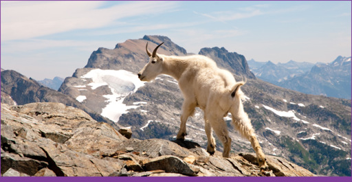
Mountain goats are at home on top the rocky mountains of the North Cascades Dan Bennett
The North Cascades are brimming with old-growth forests, hundreds of glaciers, and pure alpine lakes. They are a hikers paradise as unique in landscape as in name: North Cascades National Park Service Complex . The only of its kind, this complex unites three park units: North Cascades National Park (North and South Units), Ross Lake National Recreation Area (NRA), and Lake Chelan NRA. The mountains, named for an abundance of waterfalls, form an imposing natural barrier, preventing all but the most determined visitors from entering their depths. Many people have tried their luck at making a living among these mountains, but few succeeded. Today, that task is much easier thanks to considerable infrastructure and a healthy, but not overwhelming, tourism industry. North Cascades Scenic Highway pierces the Cascades, crossing them from east to west as the roadway runs the entire length of Ross Lake NRA. Travel further from the beaten pathinto river-carved valleys, on top of rocky ridgelines, far away from the scenic bywayand youll begin to see the landscape as its earliest inhabitants saw it, wild and free.
Native Americans lived in the mountainous environment for thousands of years. Their lives were tied to the surroundings. Two major tribes lived in the region, one on each side of the Cascades. People of the Columbia River Basin lived to the east. People of the Pacific Northwest/Puget Lowlands lived to the west. They traded between each other, blazing trails across Stehekin (meaning the way through), Cascade, and Twisp Passes. They often followed high ridgelines to avoid navigating dense vegetation common in the lower elevations. Natives lived in harmony with the land; many Americans did their best to exploit it.
Several American expeditions traversed the North Cascades, mapping and documenting what they witnessed. Fur trappers came and went. Hundreds of miners hoping to strike it rich arrived in the late 1870s. They panned for gold along the banks of the Skagit River, but found very little. The rush ended by 1880. Trees were felled and floated along the Skagit River and Lake Chelan, but inadequate transportation and infrastructure spared the forests. The most significant alterations to the landscape came in the form of three dams along the Skagit River, but for the most part this rugged land remains wild and free.
Camping (NOCA)
The park runs five drive-in campgrounds. From west to east, Goodell Creek (Milepost 112, 21 sites, $10/night), Newhalem Creek (120, 111, $12), George Lake (126, 6, free), and Colonial Creek (130, 142, $12) Campgrounds are all located along North Cascades Highway (WA-20). Hozomeen Campground (75 sites, free), located in the parks northeast corner, is accessed via Skagit Road from Canada. Reservations are only accepted at Newhalem Creek Campground. They can be reserved for $21/night by calling (877) 444-6777 or clicking www.recreation.gov . All other campsites are available on a first-come, first-served basis.
Group sites are available at Upper and Lower Goodell Creek ($25/night or $34/night with reservation) and Newhalem Creek ($32 or $41). These sites may be reserved by calling (877) 444-6777 or clicking www.recreation.gov .
There are more than 100 designated campsites for backpackers and boaters in the backcountry. Beyond park boundaries there are more than a dozen developed campgrounds in national forest, state park, and county park land.
Best of North Cascades
Attraction: North Cascades Highway
Runner-up: Stehekin
2nd Runner-up: Hozomeen
Hike: Rainy Lake/Maple Pass
Runner-up: Cascade Pass
2nd Runner-up: Rainbow Loop
Hiking (NOCA)

Cascade Pass Michael Silverman/NPS
North Cascades Highway is nice, but to share a more intimate experience with the Cascades leave the car behind and set out on foot. Nearly 400 miles of hiking trails allow guests to explore the stunning beauty of the parks river-carved valleys and glacier-capped peaks. Most trailheads are located along North Cascades Highway and in Stehekin (Lake Chelan NRA), but the true day-hikers paradise is Cascade River Road . It closes seasonally and after mile 10 is dirt and gravel, but should be passable by low clearance 2WD vehicles. The trails to Hidden Lake and Cascade Pass are this areas gems and two of the best hikes in the Cascades.
Next page
