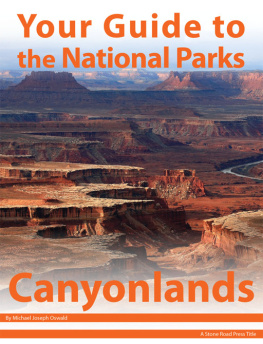
Your Guide to Canyonlands National Park, First Edition (electronic)
ISBN: 978-1-62128-029-3
Published by: Stone Road Press
Author/Cartographer/Photographer/Designer: Michael Joseph Oswald
Editor: Derek Pankratz
Copyright 2012 Stone Road Press, LLC, Whitelaw, Wisconsin. All rights reserved. No part of this publication may be reproduced, stored in a retrieval system or transmitted in any form or by any means, electronic, mechanical, photocopying, recording, scanning or otherwise without written permission of the Publisher. Requests for permission should be addressed to Stone Road Press; c/o Michael Oswald; 4927 Stone Road; Whitelaw, WI 54247.
The entire work, Your Guide to the National Parks is available in paperback and electronic versions. Content that appears in print may not be available electronically.
Paperback ISBN: 978-1-62128-000-2
Library of Congress Control Number (LCCN): 2012934277
Printed in the United States of America
E-Book ISBN: 978-1-62128-065-1
Corrections/Contact
This guide book has been researched and written with the greatest attention to detail in order to provide you with the most accurate and pertinent information. Unfortunately, travel informationespecially pricingis subject to change and inadvertent errors and omissions do occur. Should you encounter a change, error, or omission while using this guide book, wed like to hear about it. (If you found a wonderful place, trail, or activity not mentioned, wed love to hear about that too.) Please contact us by sending an e-mail to . Your contributions will help make future editions better than the last.
You can contact us online at www.StoneRoadPress.com or follow us on
Facebook: www.facebook.com/thestoneroadpress
Twitter: www.twitter.com/stoneroadpress (@stoneroadpress)
Flickr: www.flickr.com/photos/stoneroadpress
FAQs
The world of electronic media is not cut and dry like print. Devices handle files differently. Users have a variety of expectations. These e-books are image- and map-intensive, requiring fairly powerful hardware. All books were tested for use on the Kindle Fire, Nook Tablet, and iPad. You can expect to have the best user experience on one of these devices, or a similar tablet, laptop, or desktop. In the event you have issues please peruse our Frequently Asked Questions (.
Maps
Numerous map layouts were explored while developing this e-book, but in the end it was decided that the most useful map is a complete one. Unfortunately, due to file size concerns and e-reader hardware limitations, some maps included in this guide book are below our usual high standards of quality (even using zoom features). As a workaround all of this books maps are available in pdf format by clicking the link below each map or visiting www.stoneroadpress.com/national-parks/maps .
Disclaimer
Your safety is important to us. If any activity is beyond your ability or threatened by forces outside your control, do not attempt it. The maps in this book, although accurate and to scale, are not intended for hiking. Serious hikers should purchase a detailed, waterproof, topographical map. It is also suggested that you write or call in advance to confirm information when it matters most.
The primary purpose of this guide book is to enhance our readers national park experiences, but the author, editor, and publisher cannot be held responsible for any experiences while traveling.
Photo Credits
Front cover: Island in the Sky Shutterstock
Canyonlands - Introduction
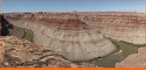
Confluence of the Colorado and Green Rivers
Canyonlands, as its name implies, is an intricate landscape of canyons carved into the Colorado Plateau. Years of erosion have revealed colorful layers of rock and formed buttes and mesas rising high above the Colorado and Green Rivers. Their water continues to carry sediment from the canyon walls and floor all the way to the Pacific Ocean. Controversial conservationist and author, Edward Abbey, described the region best when he wrote that its the most weird wonderful, magical place on earththere is nothing else like it anywhere.
Hes absolutely right. Proof lies in the geologic history recorded in layers of rock, and stories passed down over the course of 10,000 years of human inhabitance. Geology meets history at places like Horseshoe Canyon, where pictographs and petroglyphs are etched into the canyons walls. Places that werent explored or studied until miners in search of uranium fanned out across the labyrinthine canyons.
Scientists believe at one time the Colorado Plateau region was completely flat and near sea level before layers of sedimentary rock were deposited. Millions of years ago a series of geologic events, including uplifts and volcanic activity, caused the area to rise more than 5,000 feet, on average, above sea level. This increase in elevation set the stage for the Colorado and Green Rivers to cut their way through soft sedimentary rock, revealing its geologic history in the process. See for yourself in the photograph above. Notice the horizontal bands of rock in the spires and canyon walls. Red and white layers seem to alternate as you move up the geologic column. Red is created from iron-rich deposits carried here by rivers from nearby mountains. White layers are mostly sand left behind from a shallow sea that covered the region millions of years ago. The parks Upheaval Dome is an anomaly in the geologic order. Its impossible to be sure what caused this crater-like formation, and scientists continue to debate its origin. Some believe it was formed by a meteorite, while others contend a giant salt-bubble, known as a salt dome, is responsible for the abnormality.
Humans have lived in the region for more than 10,000 years. Artifacts recovered in Horseshoe Canyon date back as early as 9000 7000 BC, when mammoths still roamed the American southwest. Pictographs and petroglyphs are also present in the canyon and most notably at its Great Gallery. Ancestral Puebloans and Fremont People left mud dwellings similar in style but much smaller in size than those found at Mesa Verde National Park. It is believed that large populations of Ancestral Puebloans moved into this area around 1200 AD from Mesa Verde, planting maize, beans, and squash, and raising turkeys and dogs.
Paiute and Ute Indians moved in during the tail end of the Ancestral Puebloans presence. Neither culture did much exploration of the canyons. They simply used the land to hunt game and gather plants. European Americans arrived in the early 1800s. To fur trappers and missionaries the canyons were nothing more than an impediment to collecting pelts and reaching the west coast. By the 1880s local ranchers used the land as winter pasture. Cowboy camps, like the one visible at Cave Spring Trail in Needles, were established to help safeguard their livestock.
After WWII, the uranium boom hit southeast Utah. Prospectors filed claims all over present-day Canyonlands and nearly 1,000 miles of roads were built thanks to incentives offered by the Atomic Energy Commission. Very little uranium was found, but this new form of exploitation caused concern for Bates Wilson, Superintendent of Arches National Monument. He passionately advocated the creation of a national park, leading jeep tours through the area hoping to gain allies. Fatefully, Secretary of the Interior Stewart Udall joined a tour after peering into the canyons while flying above the Colorado Plateau. He lobbied for the park, and in 1964 legislation was passed and signed by President Lyndon B. Johnson.
Best of Canyonlands
Next page
