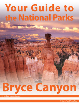
Your Guide to Bryce Canyon National Park, First Edition (electronic)
ISBN: 978-1-62128-031-6
Published by: Stone Road Press
Author/Cartographer/Photographer/Designer: Michael Joseph Oswald
Editor: Derek Pankratz
Copyright 2012 Stone Road Press, LLC, Whitelaw, Wisconsin. All rights reserved. No part of this publication may be reproduced, stored in a retrieval system or transmitted in any form or by any means, electronic, mechanical, photocopying, recording, scanning or otherwise without written permission of the Publisher. Requests for permission should be addressed to Stone Road Press; c/o Michael Oswald; 4927 Stone Road; Whitelaw, WI 54247.
The entire work, Your Guide to the National Parks is available in paperback and electronic versions. Content that appears in print may not be available electronically.
Paperback ISBN: 978-1-62128-000-2
Library of Congress Control Number (LCCN): 2012934277
Printed in the United States of America
E-Book ISBN: 978-1-62128-065-1
Corrections/Contact
This guide book has been researched and written with the greatest attention to detail in order to provide you with the most accurate and pertinent information. Unfortunately, travel informationespecially pricingis subject to change and inadvertent errors and omissions do occur. Should you encounter a change, error, or omission while using this guide book, wed like to hear about it. (If you found a wonderful place, trail, or activity not mentioned, wed love to hear about that too.) Please contact us by sending an e-mail to . Your contributions will help make future editions better than the last.
You can contact us online at www.StoneRoadPress.com or follow us on
Facebook: www.facebook.com/thestoneroadpress
Twitter: www.twitter.com/stoneroadpress (@stoneroadpress)
Flickr: www.flickr.com/photos/stoneroadpress
FAQs
The world of electronic media is not cut and dry like print. Devices handle files differently. Users have a variety of expectations. These e-books are image- and map-intensive, requiring fairly powerful hardware. All books were tested for use on the Kindle Fire, Nook Tablet, and iPad. You can expect to have the best user experience on one of these devices, or a similar tablet, laptop, or desktop. In the event you have issues please peruse our Frequently Asked Questions (.
Maps
Numerous map layouts were explored while developing this e-book, but in the end it was decided that the most useful map is a complete one. Unfortunately, due to file size concerns and e-reader hardware limitations, some maps included in this guide book are below our usual high standards of quality (even using zoom features). As a workaround all of this books maps are available in pdf format by clicking the link below each map or visiting www.stoneroadpress.com/national-parks/maps .
Disclaimer
Your safety is important to us. If any activity is beyond your ability or threatened by forces outside your control, do not attempt it. The maps in this book, although accurate and to scale, are not intended for hiking. Serious hikers should purchase a detailed, waterproof, topographical map. It is also suggested that you write or call in advance to confirm information when it matters most.
The primary purpose of this guide book is to enhance our readers national park experiences, but the author, editor, and publisher cannot be held responsible for any experiences while traveling.
Photo Credits
Front cover: Thors Hammer Ray Mathis/NPS
Bryce Canyon - Introduction
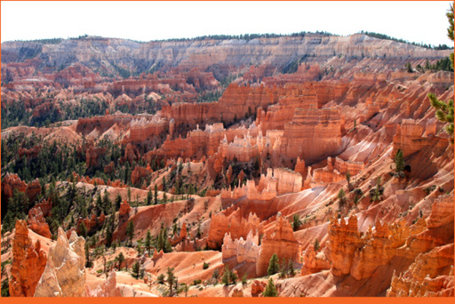
Erosion is a mysterious force
In 1918 Stephen Mather , first director and sentimental father of the National Park Service, was guided to a seldom visited attraction in southwestern Utah. His tour guides required that he close his eyes before arrival. Mather had just toured Zion National Park, but Zions colorful canyons and expanses of unspoiled wildness could not prepare him for what he was about to see. He opened his eyes at Bryce Amphitheater , where a battalion of colorful rocky spires called hoodoos were waiting to greet him. Imagine having never seen a photograph of the eerie formations that line the eastern rim of Paunsaugunt Plateau. You arrive here, open your eyes and in front of you is an indescribable masterpiece of nature. Even today, this scene has the power to stop visitors dead in their tracks. These views are so divine and empowering they are inspirational to even the most casual sightseers. This is not just a place of inspiration. Its a place capable of stirring up religious sentiments. A place that invokes deep heartfelt patriotism. A place unlike all others.
To Ebenezer Bryce , it was simply a hell of a place to lose a cow. In 1875, the Church of Jesus Christ of Latter-day Saints sent Bryce to settle the Paria Valley. He and his family chose to live right below what is known today as Bryce Amphitheater. Bryce built a home for his family, a canal for his crops and his cows, and a road to collect wood used to heat his home during the cool evenings and chilly winters. It became clear that Bryce and his family were sticking around, and soon locals began to call the area Bryce Canyon. Not a true canyon, its actually a horseshoe-shaped bowl or amphitheater formed by several creeks and streams rather than a single river and its tributaries. Life in and around Bryce Canyon was difficult. Herds of sheep and cattle quickly overgrazed the areas limited vegetation and the region was ravaged by cycles of drought and flooding. Settlers attempted to build a water diversion channel from the Sevier River to protect their crops, cattle, and homes from seasonal floods. The effort failed, and shortly after most settlers, including the Bryce family, left the area.
Capitulation in the face of nature has been a recurring theme in the history of southwest Utah. More than 8,000 years ago humans first visited the region, only to find it exceedingly difficult to survive for an extended period of time. Later, the Fremont Culture lived in the area, hunter-gatherers who supplemented their diet with modest amounts of cultivated crops like corn and squash. By the mid-12th century, they also abandoned the region. Paiute Indians moved in, living much like the Fremont Culture, hunting and gathering. Paiute legends grew around the origin of the peculiar rock formations, or hoodoos. They called them anka-ku-was-a-wits or red painted faces, and believed they were the Legend People turned to stone at the hands of the Coyote God.
Hoodoos may resemble beautifully colored humans sculpted from stone, but they are simply the result of thousands of years of continuous erosion. Minarets of soft sedimentary rock were left behind because they are topped by a piece of harder, less easily eroded stone. This caprock protects the column of sedimentary rock below from the erosive forces of wind, water, and ice. Several locations around the world display similar rocky spires, including nearby Cedar Breaks National Monument , but Bryce is different. Its more colorful, more abundant, and more mystical.
Bryce Canyon is a special place. A place woven into the legends of early inhabitants. A place where Ebenezer Bryces cows got lost. A place that screamed surprise to Stephen Mather when he opened his eyes. A place that was almost completely inaccessible until the Union Pacific Railroad laid down track in the 1920s and the CCC built roads in the 1930s. Today, Bryce Canyon is a place accommodating to visitors, a place that will open your eyes to the natural beauty of the world around you. So close your eyes and open them once more at the rim of Bryce Canyon.
Driving (BRCA)
The parks Scenic Drive is an 18-mile one-way paved road providing access to the most spectacular viewpoints. All 14 viewpoints are on the east side of the road, so it is suggested that motorists proceed to Rainbow Point (the end) and stop at viewpoints as you head north on your return trip. Each viewpoint offers unique views, but overlooks found around Bryce Amphitheater present the most memorable panoramas.
Next page
