Contents

Your Guide to the National Parks of the West, First Edition (electronic)
ISBN: 978-1-62128-062-0
Published by: Stone Road Press
Author/Cartographer/Photographer/Designer: Michael Joseph Oswald
Editor: Derek Pankratz
Copyright 2012 Stone Road Press, LLC, Whitelaw, Wisconsin. All rights reserved. No part of this publication may be reproduced, stored in a retrieval system or transmitted in any form or by any means, electronic, mechanical, photocopying, recording, scanning or otherwise without written permission of the Publisher. Requests for permission should be addressed to Stone Road Press; c/o Michael Oswald; 4927 Stone Road; Whitelaw, WI 54247.
The entire work, Your Guide to the National Parks is available in paperback and electronic versions. Content that appears in print may not be available electronically.
Paperback ISBN: 978-1-62128-000-2
Library of Congress Control Number (LCCN): 2012934277
Printed in the United States of America
E-Book ISBN: 978-1-62128-0 65-1
Corrections/Contact
This guide book has been researched and written with the greatest attention to detail in order to provide you with the most accurate and pertinent information. Unfortunately, travel informationespecially pricingis subject to change and inadvertent errors and omissions do occur. Should you encounter a change, error, or omission while using this guide book, wed like to hear about it. (If you found a wonderful place, trail, or activity not mentioned, wed love to hear about that too.) Please contact us by sending an e-mail to . Your contributions will help make future editions better than the last.
You can contact us online at www.StoneRoadPress.com or follow us on
Facebook: www.facebook.com/thestoneroadpress
Twitter: www.twitter.com/stoneroadpress (@stoneroadpress)
Flickr: www.flickr.com/photos/stoneroadpress
FAQs
The world of electronic media is not cut and dry like print. Devices handle files differently. Users have a variety of expectations. These e-books are image- and map-intensive, requiring fairly powerful hardware. All books were tested for use on the Kindle Fire, Nook Tablet, and iPad. You can expect to have the best user experience on one of these devices, or a similar tablet, laptop, or desktop. In the event you have issues please peruse our Frequently Asked Questions (.
Maps
Numerous map layouts were explored while developing this e-book, but in the end it was decided that the most useful map is a complete one. Unfortunately, due to file size concerns and e-reader hardware limitations, some maps included in this guide book are below our usual high standards of quality (even using zoom features). As a workaround all of this books maps are available in pdf format by clicking the link below each map or visiting www.stoneroadpress.com/national-parks/maps .
Disclaimer
Your safety is important to us. If any activity is beyond your ability or threatened by forces outside your control, do not attempt it. The maps in this book, although accurate and to scale, are not intended for hiking. Serious hikers should purchase a detailed, waterproof, topographical map. It is also suggested that you write or call in advance to confirm information when it matters most.
The primary purpose of this guide book is to enhance our readers national park experiences, but the author, editor, and publisher cannot be held responsible for any experiences while traveling.
Photo Credits
Front cover: The Racetrack Shutterstock
Channel Islands - Introduction
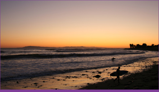
Surfing at Ventura Beach with the Channel Islands in the distance
Off the coast of California, less than 100 miles away from 18 million people living in the Greater Los Angeles Area, is a group of eight islands. Compared to their surroundings, the Channel Islands have been left undeveloped even after continuous inhabitation for at least the last 8,000 years. Five of these islandsSanta Barbara, Anacapa, Santa Cruz, Santa Rosa, and San Miguelcomprise Channel Islands National Park. Rich history combined with incredibly diverse and often unique ecology make these volcanic islands stand alone in the National Park portfolio.
The parks geology is constantly changing thanks to relentless pounding of water on rock. However, the most startling change to the islands wasnt caused by waters erosive powers, but by its absence. More than 13,000 years ago, a blink of an eye in geologic terms, the four northern islands were one super-island. North America was in the middle of the last great Ice Age and water level was much lower than it is today. Climatic changes caused the glaciers to recede. As water levels rose the lowest valleys flooded, ultimately disconnecting the islands from one another.
Geologic changes also drastically altered the islands ecology . Approximately 20,000 years ago, mammoths swam to the super-island, likely searching for vegetation whose scent was carried by the prevailing westward winds. As their population grew, resources became depleted. Natural selection favored smaller mammoths capable of surviving on less food. The woolly beasts lived on the islands for about 10,000 years before becoming extinct. Evidence of mammothsonce the most widely spread mammalhas been found on four continents. An engraving on a tusk found in a rock shelter in southwestern France. The carcass of a baby male preserved frozen in Siberias permafrost. More than 100 mammoth remains at the bottom of a sinkhole in Hot Springs, SD. And a pygmy mammoth here on Santa Rosa Island. When these miniature remains were discovered in 1873 scientists believed that elephants inhabited the islands. More than 100 years later, additional fossils helped conclude that they were in fact pygmy mammoths, about one-tenth the size of a typical Columbian mammoth. They measured between 4.5 and 7-feet tall, weighing about one ton. A Colombian mammoth measured up to 14-feet tall, and weighed as much as ten tons. Human fossils have also been found on the Channel Islands. At Arlington Springs, on Santa Rosa Island, scientists discovered human remains dating back more than 13,000 years. This find has become known as Arlington woman, and it is among the oldest remains found in North America.
Humans have had a considerable effect on the islands. Early Chumash people relied on the sea for food and tools, traveling between the islands and mainland in canoes, called tomols, hollowed out from redwood trees that drifted down the coast. The Chumash were present when Juan Rodriguez Cabrillo reached San Miguel Island in 1542. Cabrillo and his fellow explorers introduced disease and overhunted sea life; by the 1820s the entire surviving island Chumash population had moved to the mainland.
Over the course of the next century, the island was home to Mexican prisoners , ambitious ranchers , and hermit fishermen . In 1864, the Civil War increased demand for wool and more than 24,000 sheep grazed the hills of Santa Cruz. During prohibition, Raymond Frenchy LeDreau watched over caches of liquor stored in Anacapas caves. When Santa Cruz became part of the new National Monument, Frenchy was allowed to remain on the island as its caretaker. In 1956, at the age of 80, he was forced to leave after suffering severe injuries due to a fall. In 1969, more than 100,000 barrels of crude oil spilled into the Channel during the Santa Barbara oil spill, at the time the largest oil spill in United States waters. The National Park Service and Nature Conservancy have worked since to preserve this picturesque landscape and its unique ecosystem for the thousands of visitors that arrive each year.
Next page
