Your Guide to Crater Lake National Park, First Edition (electronic)
ISBN: 978-1-62128-042-2
Published by: Stone Road Press
Author/Cartographer/Photographer/Designer: Michael Joseph Oswald
Editor: Derek Pankratz
Copyright 2012 Stone Road Press, LLC, Whitelaw, Wisconsin. All rights reserved. No part of this publication may be reproduced, stored in a retrieval system or transmitted in any form or by any means, electronic, mechanical, photocopying, recording, scanning or otherwise without written permission of the Publisher. Requests for permission should be addressed to Stone Road Press; c/o Michael Oswald; 4927 Stone Road; Whitelaw, WI 54247.
The entire work, Your Guide to the National Parks is available in paperback and electronic versions. Content that appears in print may not be available electronically.
Paperback ISBN: 978-1-62128-000-2
Library of Congress Control Number (LCCN): 2012934277
Printed in the United States of America
E-Book ISBN: 978-1-62128-065-1
Corrections/Contact
This guide book has been researched and written with the greatest attention to detail in order to provide you with the most accurate and pertinent information. Unfortunately, travel informationespecially pricingis subject to change and inadvertent errors and omissions do occur. Should you encounter a change, error, or omission while using this guide book, wed like to hear about it. (If you found a wonderful place, trail, or activity not mentioned, wed love to hear about that too.) Please contact us by sending an e-mail to . Your contributions will help make future editions better than the last.
You can contact us online at www.StoneRoadPress.com or follow us on
Facebook: www.facebook.com/thestoneroadpress
Twitter: www.twitter.com/stoneroadpress (@stoneroadpress)
Flickr: www.flickr.com/photos/stoneroadpress
FAQs
The world of electronic media is not cut and dry like print. Devices handle files differently. Users have a variety of expectations. These e-books are image- and map-intensive, requiring fairly powerful hardware. All books were tested for use on the Kindle Fire, Nook Tablet, and iPad. You can expect to have the best user experience on one of these devices, or a similar tablet, laptop, or desktop. In the event you have issues please peruse our Frequently Asked Questions (.
Maps
Numerous map layouts were explored while developing this e-book, but in the end it was decided that the most useful map is a complete one. Unfortunately, due to file size concerns and e-reader hardware limitations, some maps included in this guide book are below our usual high standards of quality (even using zoom features). As a workaround all of this books maps are available in pdf format by clicking the link below each map or visiting www.stoneroadpress.com/national-parks/maps .
Disclaimer
Your safety is important to us. If any activity is beyond your ability or threatened by forces outside your control, do not attempt it. The maps in this book, although accurate and to scale, are not intended for hiking. Serious hikers should purchase a detailed, waterproof, topographical map. It is also suggested that you write or call in advance to confirm information when it matters most.
The primary purpose of this guide book is to enhance our readers national park experiences, but the author, editor, and publisher cannot be held responsible for any experiences while traveling.
Crater Lake - Introduction
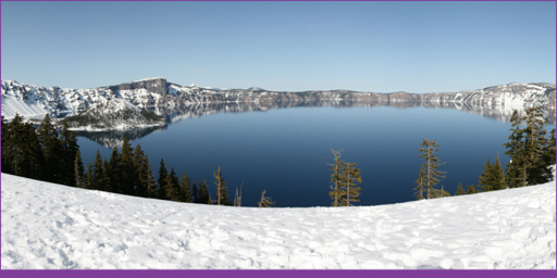
A view of Crater Lake and Wizard Island from Discovery Point
Nearly 8,000 years ago a cataclysmic eruption of Mount Mazama caused the mountain to shatter and collapse into itself, forming a massive 5-mile wide caldera rimmed by cliffs almost 4,000 feet high. Sealed by molten rock, the caldera gradually filled with water from melted snow and rain. The lakes water level has finally settled; seepage and evaporation balance the incoming flow. After 750 years, roughly five trillion gallons of almost perfectly pure water filled the caldera, creating one of the most impressive natural settings in the world. Crater Lake is so deep (up to 1,943-feet, 1,148-feet on average) and so pure that the true blueness of water becomes obviously, almost indescribably, apparent. Today, soaring cliffs line a lake whose brilliant deep blue hue leaves guests, past and present, spellbound.
Makala Indians have their own legend about the creation of Crater Lake. Llao, Chief of the Below World, sometimes came up from the earth to stand atop Mount Mazama. On one of his visits, Llao fell in love with the Makalak chiefs beautiful daughter. Llao promised her eternal life if she would return with him to his home below the mountain. She refused. Enraged, Llao began to pummel the village with balls of fire. Skell, Chief of the Above World, witnessed Llaos rage from the top of Mount Shasta. He took pity on the helpless villagers and chose to wage war with Llao. The two chiefs hurled fiery hot boulders at one another from their respective mountains. The earth trembled in the wake of their violence. As villagers fled to the waters of Klamath Lake two holy men remained behind. Their plan was to jump into the fiery pit hidden within Llaos mountain as a sacrifice to the Chief of the Below. Moved by their bravery, Skell ambushed Llao, driving him back into Mount Mazama where the fight raged on through the night. The following morning, Mount Mazama was gone. In its place was a gaping hole that filled with water from torrents of rain, which fell after the epic battle.
Makalak Indians may well have witnessed the formation of Crater Lake. Evidence of permanent ancient settlement has not been found, but the area was used for seasonal hunting and gathering, vision-quests, and prayer for at least 10,000 years. Mount Mazama erupted about 7,700 years ago. The event produced more than 100 times as much ash as Mount St. Helens eruption in 1980, scattered as far south as central Nevada, as far west as Yellowstone National Park, and as far north as British Columbia. After its eruption Indians were definitely aware of the lake that filled the caldera of Mount Mazama; they believed it took great power and strength to look at the pure blue waters. Even today, Klamath Indians (descendants of the Makalak) refuse to look at the lake for religious reasons.
John Wesley Hillman , the first white man to glimpse Crater Lake, had no such religious proclivities. After returning from a successful gold mining trip in California, Hillman funded a small gold mining expedition into Oregons southern Cascades. On June 12, 1853, the group reached present day Discovery Point where a lake of incomprehensible majesty was on display. They named it Deep Blue Lake, returned to civilization to restock supplies, and continued on their quest for gold. William Gladstone Steel visited the area in 1885. It was still used by local Indians for hunting, gathering, and religious purposes, but Steel spent the next 17 years campaigning for the creation of Crater Lake National Park (the name preferred by locals over the likes of Blue Lake, Lake Majesty, and the original, Deep Blue Lake). Steel named other features: Wizard Island, Llao Rock, and Skell Head. On May 22, 1902, Steels efforts came to fruition when President Roosevelt signed legislation creating Crater Lake, the 6th oldest national park. Steels focus shifted to making the area a spectacle catering to wealthy tourists. It was a difficult task considering that the rim receives more than 40 feet of snow annually. Erection of Crater Lake Lodge was constantly over-budget and behind schedule. In 1915 the lodge finally opened to popular fanfare, but it remained in a relatively constant state of construction. Three years later Rim Drive was completed and the park was officially open for business.
Next page
