Richard Cannings - British Columbia. A Natural History of Its Origins, Ecology, and Diversity with a New Look at...
Here you can read online Richard Cannings - British Columbia. A Natural History of Its Origins, Ecology, and Diversity with a New Look at... full text of the book (entire story) in english for free. Download pdf and epub, get meaning, cover and reviews about this ebook. year: 2015, publisher: Perseus Books Group;Greystone Books, genre: Children. Description of the work, (preface) as well as reviews are available. Best literature library LitArk.com created for fans of good reading and offers a wide selection of genres:
Romance novel
Science fiction
Adventure
Detective
Science
History
Home and family
Prose
Art
Politics
Computer
Non-fiction
Religion
Business
Children
Humor
Choose a favorite category and find really read worthwhile books. Enjoy immersion in the world of imagination, feel the emotions of the characters or learn something new for yourself, make an fascinating discovery.

- Book:British Columbia. A Natural History of Its Origins, Ecology, and Diversity with a New Look at...
- Author:
- Publisher:Perseus Books Group;Greystone Books
- Genre:
- Year:2015
- Rating:4 / 5
- Favourites:Add to favourites
- Your mark:
British Columbia. A Natural History of Its Origins, Ecology, and Diversity with a New Look at...: summary, description and annotation
We offer to read an annotation, description, summary or preface (depends on what the author of the book "British Columbia. A Natural History of Its Origins, Ecology, and Diversity with a New Look at..." wrote himself). If you haven't found the necessary information about the book — write in the comments, we will try to find it.
This revised and expanded edition of an award-winning book not only explores British Columbias stunning ecology but also features an increased focus on climate change. With expanded sections on the provinces geological history, updated information on the mountain pine beetle and the future of B.C.s biodiversity, and fresh information on many other topics, this edition includes new illustrations, photos, sidebars, and new and revised maps.
Both an authoritative reference and an easy-to-read guide, this revised edition is a must for anyone who wants detailed and up-to-date information about British Columbias dazzling natural world.
Richard Cannings: author's other books
Who wrote British Columbia. A Natural History of Its Origins, Ecology, and Diversity with a New Look at...? Find out the surname, the name of the author of the book and a list of all author's works by series.


British Columbia. A Natural History of Its Origins, Ecology, and Diversity with a New Look at... — read online for free the complete book (whole text) full work
Below is the text of the book, divided by pages. System saving the place of the last page read, allows you to conveniently read the book "British Columbia. A Natural History of Its Origins, Ecology, and Diversity with a New Look at..." online for free, without having to search again every time where you left off. Put a bookmark, and you can go to the page where you finished reading at any time.
Font size:
Interval:
Bookmark:
COLUMBIA
ECOLOGY, AND DIVERSITY
WITH A NEW LOOK AT CLIMATE CHANGE

THE EARTH IS TRULY MISNAMED, for it is water that covers most of this planet, and the waters coursing through the huge ocean basins shape the patterns of life found on all continents. British Columbia sits on the eastern edge of the largest mass of water in the world, the Pacific Ocean, and it is the primary force designing the tapestry of life in the province. Great geological forces have created the giant canvas we call British Columbia, but it is painted by the Pacific.
There are patterns within these Pacific waters, patterns of waves and currents, temperature and salinity, light and darkness. These patterns shape a massive food chain, channelling energy from tiny plants through shrimp and fish and birds, onto the shore and into the rivers and mountains. The warmth and moisture of this great ocean, warmth and moisture needed by all living things, are carried by westerly winds and waves to coastal forests, over ice-covered mountains and into Interior valleys. The events in the atmosphere abovestorms lashing the coast with rain, Arctic air flooding the Interior plateausare the actions of weather. The seasonal patterns of weather, patterns of hot and cold, warm and dry, cloud and sun, are the stuff of climate.
British Columbia meets the Pacific Ocean along a rugged outer coast, a windward coast where dark rock walls meet green waves and white foam before sinking into the sea. The rocky floor slopes down to a depth of 200 metres or so to form the continental shelf, a mosaic of sunken headlands and river-borne debris. The shelf extends 40 to 90 kilometres offshore before it too slopes steeply down to the proverbial bottom of the sea almost 2 kilometres below the waves. The continental shelf is widest along the southwestern edge of Vancouver Island, narrowing to the north, and is almost nonexistent off the Haida Gwaii, where the Pacific is already 2.5 kilometres deep only 30 kilometres from shore.
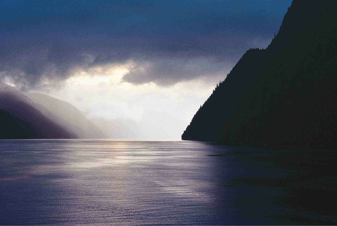
The mainland coast of British Columbia is protected along its length by a myriad of islands and narrow inlets. This inner coast is much calmer than the outer shores of the islands. Surface waters are often rather fresh, fed from Pacific storms slamming into immovable mountains and from summer glacial melt. The Strait of Georgia is the largest body of protected salt water on the coast, the submerged part of the Georgia Depression between the metamorphic rocks of Vancouver Island and the granitic Coast Mountains. Other inshore waters along the coast are mostly long, narrow inlets. These inlets are fiords, valleys plowed out by glaciers spilling through the mountains from Interior ice fields and then left to the sea as the ice pack dwindled and disappeared.
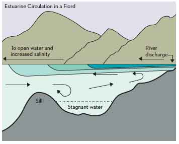
FIGURE 2.1: Cross-section of an estuary and fiord. The fresh river discharge flows out to sea on the surface, drawing the upper layer of sea water with it. This layer is replaced from below by a deep countercurrent, a process called entrainment. Adapted from R. E. Thomson, Oceanography of the British Columbia Coast, Fig. 2.7.
The glaciers scoured out the floors of these fiords to depths of 600 metres or sothree times that of the continental shelfand left almost vertical valley walls. Fiords are not known for their sandy beaches; their shores plunge directly into the sea. Each glacier also left at least one terminal moraine in its fiord, a massive wall of rubble pushed ahead of the glacier and marking its farthest advance. These submerged moraines are called sills, barriers that separate the deep inner zone of the fiord from the outer seafloor. Sill floors are shallow, sunlit and vibrant with undersea life, nurtured by strong tidal currents pouring in and out of the fiord twice a day. The deep inner waters, isolated from the open ocean and the oxygen-rich surface, are often stagnant and relatively lifeless ().
EL NIO
Peruvian mariners gave this namewhich means The Child in Spanishto a current that often appears around Christmas along the Pacific coast of South America. Normally, easterly trade winds carry tropical waters away from the South American coast. Occasionally these winds fail, and the equatorial waters piled up in the western Pacific slosh back to the shores of South America as El Nio. A strong El Nio current can bring warm, clear, blue tropical waters north to British Columbia, radically affecting local marine life. The water is clear because it has almost no nutrients and therefore little life, forcing subtropical marine animals north in a desperate search for food. At this time, Brown Pelicans dive for fish off Race Rocks in the Juan de Fuca Strait, huge Leatherback Sea Turtles glide through Active Pass, and large, disk-shaped sunfish bask on their sides off Cape Scott. Local fish are forced north as well, and seabirds that normally feed on the rich schools of fish and shrimp west of Vancouver Island disperse to avoid starvation. El Nio also affects climate; the warm air and water intensify the Aleutian low-pressure zone, bringing stronger winter storms to British Columbia.
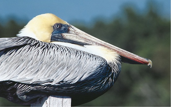
Brown Pelican
The Pacific meets the British Columbia coast against rain-lashed mountains, and the fresh water pouring out of these mountains plays an important part in the coastal marine environment. The flow of large rivers is especially important; at maximum flow in early June, the Fraser can turn the surface layer of the entire Strait of Georgia into a large, brackish lake.
Besides water, rivers and creeks also carry nutrient-laden silt into the sea. Many of these nutrients are trapped and held in the estuary at the mouth of the river, making the deltas jewels of life embedded in an already rich coastline. As the fresh water of a river meets the sea, it flows out on top of the heavier salt water in a thick wedge, thicker near the river mouth, thinner out to sea. As it flows over the salt water, it pulls the upper layers of the heavier water along with it, a process called entrainment. This water is replaced from below, creating a deep countercurrent of saline water in the estuary. Most silt and detritus sinking into the salt water below the brackish wedge is thus carried back towards the river mouth and deposited on the bottom. The Fraser alone adds 20 million tonnes of silt to its delta each year.
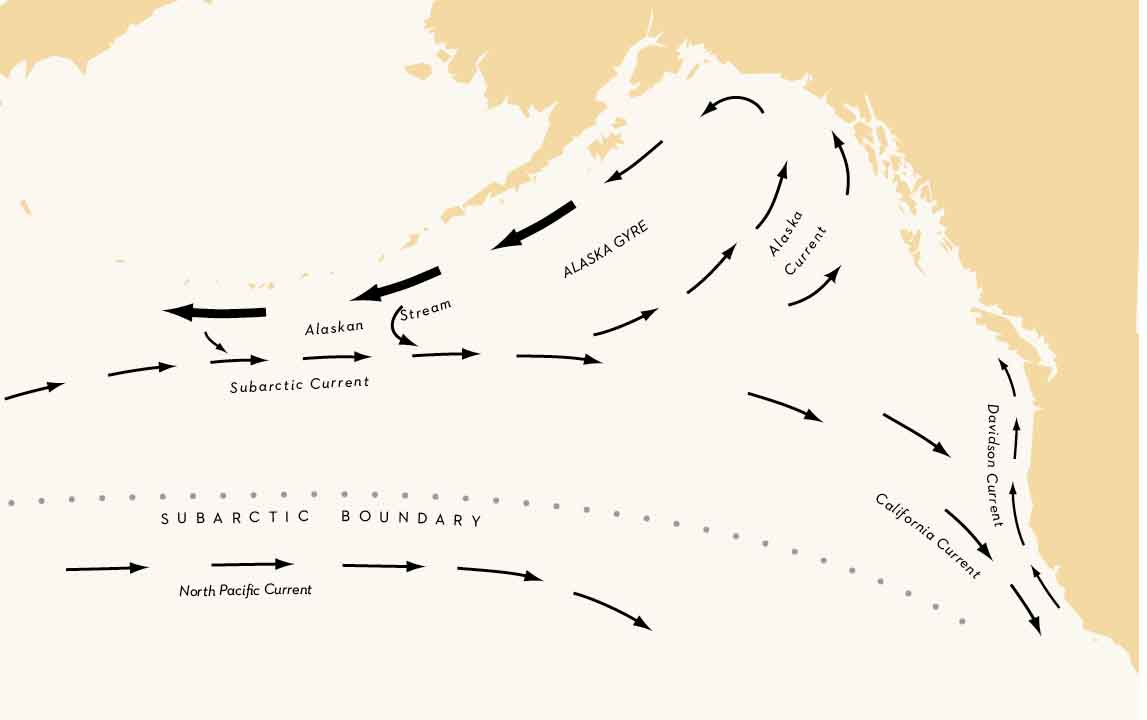
MAP 13: SURFACE CURRENTS
Surface currents in the North Pacific Ocean. Double arrows indicate a stronger current. Adapted from R. E. Thomson, Oceanography of the British Columbia Coast, Fig. 13.17.
Oceanic currents are sections of huge gyresimmense eddies of water driven by prevailing winds. Since the prevailing winds at the latitude of British Columbia are westerlies, most of the surface flow in the Pacific Ocean at that latitude is westerly as well (Map 13). It is a steady but slow flow; at a speed of 4 to 8 kilometres a day, a parcel of water off the coast of Japan could take two to five years to cross the Pacific to British Columbia. This westerly flow is divided into the Subarctic and North Pacific Currents, separated by the Subarctic Boundary, a line where precipitation matches evaporation. The balance between precipitation and evaporation is of critical importance to surface salinity. South of the Subarctic Boundary, evaporation removes water from the surface faster than precipitation can replace it. Since the salts are retained, the surface water becomes more saline. North of the boundary, precipitation adds water to the salt solution, diluting it and lowering the salinity. This abrupt change in salinity at the Subarctic Boundary acts as a very real barrier between the two currents. It is also a barrier to fish movementstuna prefer to stay in the warm waters south of the boundary, while salmon remain in the cold, rich waters to the north (see box entitled El Nio).
Font size:
Interval:
Bookmark:
Similar books «British Columbia. A Natural History of Its Origins, Ecology, and Diversity with a New Look at...»
Look at similar books to British Columbia. A Natural History of Its Origins, Ecology, and Diversity with a New Look at.... We have selected literature similar in name and meaning in the hope of providing readers with more options to find new, interesting, not yet read works.
Discussion, reviews of the book British Columbia. A Natural History of Its Origins, Ecology, and Diversity with a New Look at... and just readers' own opinions. Leave your comments, write what you think about the work, its meaning or the main characters. Specify what exactly you liked and what you didn't like, and why you think so.