IMAGES
of America
SAN DIEGOS
NORTH PARK
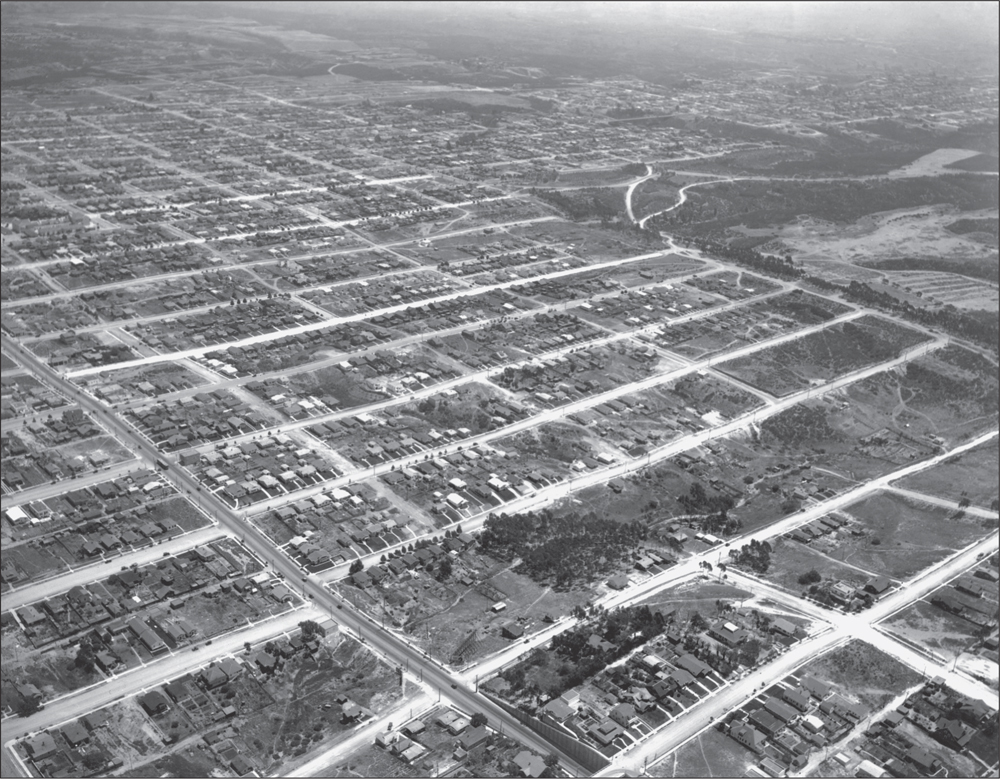
ABOVE NORTH PARK, 1926. The mismatched street grid resulting from North Parks patchwork of subdivision mapping is evident in this aerial view that looks eastward from the Georgia Street Bridge over University Avenue (lower edge). Morley Field (upper right) shows remnants of the 1915 cavalry encampment. The tracts of Paulys Addition and Park Villas are in the center, with University Heights on the left edge and West End in the distance. (Courtesy of San Diego History Center.)
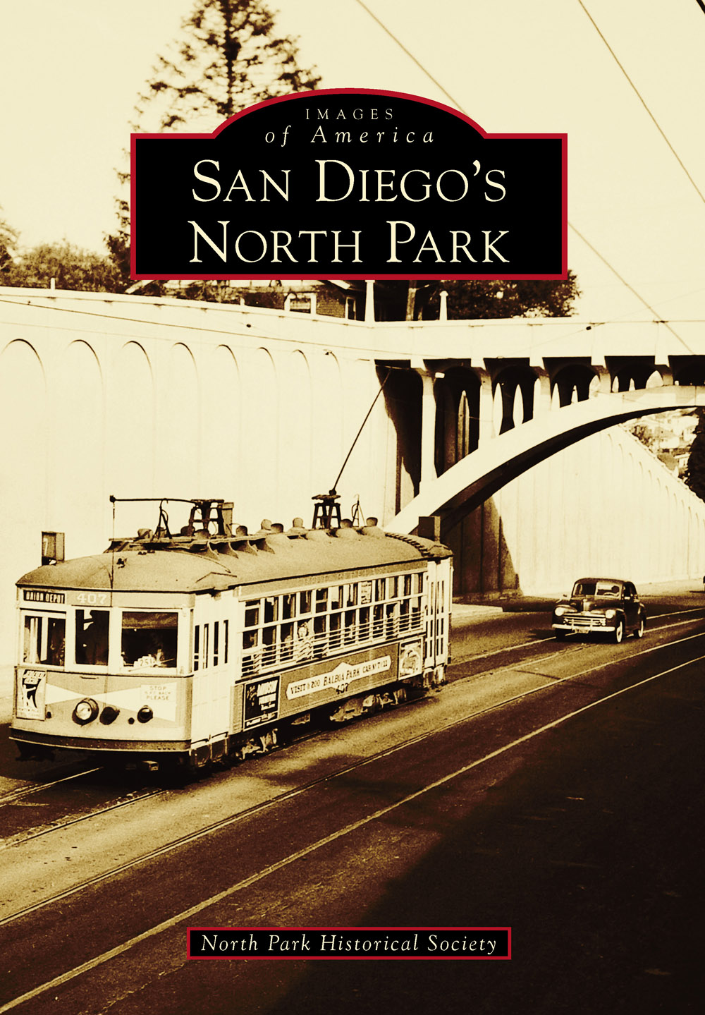
ON THE COVER: STREETCAR AT THE GEORGIA STREET BRIDGE, 1949. Rumbling west on University Avenue, this streetcar on the No. 7 line has just passed under the Georgia Street Bridge. The initial cut through the hill at this location in 1907 allowed extension of the streetcar eastward from Hillcrest to Fairmont Avenue. With a public transportation system in place, North Park developed from a near-empty mesa to an urban community. (Courtesy of Randy Sappenfield.)
IMAGES
of America
SAN DIEGOS
NORTH PARK
North Park Historical Society

Copyright 2014 by North Park Historical Society
ISBN 978-1-4671-3225-1
Ebook ISBN 9781439647172
Published by Arcadia Publishing
Charleston, South Carolina
Library of Congress Control Number: 2014933722
For all general information, please contact Arcadia Publishing:
Telephone 843-853-2070
Fax 843-853-0044
E-mail
For customer service and orders:
Toll-Free 1-888-313-2665
Visit us on the Internet at www.arcadiapublishing.com
CONTENTS
ACKNOWLEDGMENTS
This book represents an all-volunteer effort by members of the North Park Historical Society (www.northparkhistory.org). Those who authored text and obtained photographs include Ed Orozco, Randy Sappenfield, Stephen Hon, Katherine Hon, Valerie Hayken, Jody Surowiec, Sharon Turner, Paul Spears, George Franck, Melanie Gilbert, Louise Russell, Michael Thornhill, and Hilda Yoder. The first six authors listed and Sarah Lara-Toney conducted the formidable task of compiling the book layout. We thank Philip Shirk at Vintage Religion for providing meeting space at his store and Jared Nelson at Arcadia Publishing for providing essential guidance. We appreciate the help of Chris Travers and Jane Kenealy, and especially Carol Myers at the San Diego History Center Research Library. Purchase of San Diego History Center photographs was facilitated by grants from San Diego County Community Enhancement Program, and we sincerely thank county supervisor Ron Roberts for his support. We are grateful to Chris Wray, who generously provided his own historical photographs and assisted us in obtaining others. Those who also contributed their photographs include Michael Good, Donald Madison, Chuck LaBella, Denis Pollak, Roland Blase, Raymond Cooper, Vince Sund, Donna Couchman, Frances Ilig, Charlene Craig, Maria DiGregorio, Joe Schloss, Vicki Granowitz, Ben Press, Vernetta Bergeon, Donald Taylor, Patrick Edwards, Christian Michaels, Paul Body Photography, Larry Hall, Bruce Guy, Stuart Hartley, Japanese American Historical Society of San Diego (through Linda Canada), Hartley family, Stern family, Romano family, Covington family, St. Patricks Church, Trinity Methodist Church (through Margaret Dick), Plymouth Congregational Church, St. Augustine High School (through Casey Callery), McKinley Elementary School (through Pat Taylor), Lafayette Hotel, North Park Library (through Matthew Nye), San Diego Electric Railway Association, BHend and Kaufmann Archives, North Park Lions Club, Bank of America, Merrie Monteagudo, and San Diego Union Tribune/Zuma Press. Unless otherwise noted, all images appear courtesy of the San Diego History Center.
We thank Valerie Hayken Photography & Design (VHPD), a North Park small business, for donating over 200 hours of time scanning and preparing images for publication. Without their expertise, this project would have been considerably more difficult and expensive. VHPD specializes in photo restoration and fine-art landscape photography.
INTRODUCTION
Dubbed one of the countrys hippest places in 2012 by Forbes Magazine, North Park fascinates visitors and residents alike with its visible history. Homes built at the beginning of the 20th century shine in Craftsman and Spanish Revival glory. Art Deco and Modernist shop buildings reflect North Parks role as a regional commercial center following World War II. Although the exciting 1950s were followed by decades of decline, North Park is flourishing again.
The story of North Park began in the 1870s, nearly four decades before any urban development. Spurred by the enthusiasm of Alonzo Hortons New Town and dreams of a railroad connection, investors bought land made available by the city government. Two pioneer merchants, Aaron Pauly and Joseph Nash, and the city trustees bought three pueblo lots that encompassed the area between University Avenue and Upas Street and created three subdivisions: Paulys Addition, Park Villas, and West End. Favoring Hortons Addition downtown, the city trustees disregarded the configuration of the neighboring Park Villas subdivision and provided wider streets, shorter blocks, and six (instead of four) east-west streets for their West End subdivision. Adding to the mismatching, the College Hill Land Association mapped its large University Heights subdivision from University Avenue to the slopes above Mission Valley in 1888 with a street grid that ignored the subdivision mapping to the south. In 1893, James Hartley bought 40 acres in the Park Villas subdivision for a citrus orchard and named his property Hartleys North Park. With its reference to the large City (now Balboa) Park, North Park became a convenient collective name for the entire area. What that area actually encompasses has been the subject of confusion since before 1909, when the San Diego Daily Transcript noted in its February 11 issue that the City Council has as yet been unable to determine the exact boundaries of the North Park Addition. In the 1980s, the City of San Diego defined the Greater North Park Community Planning Area as bounded by the Interstate 805 freeway on the east, Park Boulevard on the west, the hills above Mission Valley on the north, and Juniper Street on the south. This book includes stories and scenes within the community planning area and the Morley Field area of Balboa Park, which has long been considered North Parks backyard.
Through cycles of boom and bust, North Park grew as people with vision and determination invested in infrastructure, homes, and businesses. Three streetcar lines of the San Diego Electric Railway brought people to the nearly empty mesa in the early 1900s. The streetcars ran along Adams Avenue (No. 11), University Avenue (No. 7), and Thirtieth Street (No. 2). Lines No. 7 and 2 resulted in the construction of iconic bridges, one at Georgia Street and the other over Switzer Canyon. The two lines met at University Avenue and Thirtieth Street in 1911 and created the Busy Corner, then and now the commercial heart of the community.
Another key building block was a reliable water supply. In 1909, an 18-million-gallon concrete reservoir with a wooden roof was completed; it covered the entire block south of Howard Avenue. Achieving adequate water pressure required a raised tank, which was completed in 1910 and served until 1924. That year, the PittsburghDes Moines Steel Company built a 1.2-million-gallon elevated steel tank. Although it is now empty due to seismic standards implemented in the 1990s, the tank remains North Parks most visible landmark and was listed in the National Register of Historic Places in 2013.
Next page

