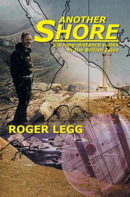
Another Shore
Six long-distance walks in the
British Isles
Roger Legg
Copyright 2013 by Roger Legg.
Library of Congress Control Number: | 2012923891 |
ISBN: | Hardcover | 978-1-4797-6965-0 |
Softcover | 978-1-4797-6964-3 |
Ebook | 978-1-4797-6966-7 |
All rights reserved. No part of this book may be reproduced or transmitted
in any form or by any means, electronic or mechanical, including photocopying, recording, or by any information storage and retrieval system,
without permission in writing from the copyright owner.
Rev. date: 03/09/2013
To order additional copies of this book, contact:
Xlibris Corporation
0-800-644-6988
www.xlibrispublishing.co.uk
304783
Contents
To Mark and Ruth
with love and affection
Often he wondered what new shores were there.
In thought he saw the still light on the sand,
The shallow water clear in tranquil air,
and walked through it in joy from strand to strand.
Edwin Muir
Sketches by Ruth Redgrave.
Maps and photos by the author.
(The maps are oriented
to the north unless otherwise shown.)
Ever since Boy Scout days, when we were encouraged to hike, I have obtained a great deal of pleasure from walking. On the whole I do not like following footpath routes designated by Acts of Parliament nor following books of instructions on how to get from A to B proceed for one mile; turn left at the farm gate; be careful of the marsh at the bottom of hill .... It all sounds a bit like joining the army and often fails to get the walker off the beaten track. Rather, to plan my own route, to use map and compass and to make my own decisions is far more appealing.
This book is about six log-distance walks that I have made in the British Isles from 1980 to 1991. There have been other journeys and the record of these may have to wait for another volume. However, I trust that the reader will enjoy my adventures; as that great walker George Borrow said many years ago:
.... these British Islands
where more strange things are every day occurring,
whether in road or street, house or dingle
* * *
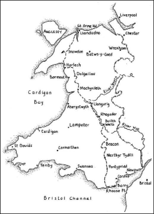
Welsh Wayoverall route
Welsh Way
Niwl ar mor, glaw ar ei ol
Niwl ar y mynyd, tes ir glennydd.
Mist from the sea, rain to follow,
Mist from the mountains, sun on the shore.
My affection for Wales goes back many years. As with so many people, Snowdonia opened my eyes to the beauty and challenge of mountains and, since my first visit in my late teens, I have returned several times over the years with my family and friends. Other memories include holidays in Pembrokeshire, canoeing the River Wye with my daughter Ruth and in the great heat-wave of 1976, as part of a journey from Lowestoft, I walked to St Davids across South Wales, a journey full of interest and, remarkably, one in which the sun shone every day from a cloudless sky, with never a drop of rain.
For a more complete picture of this ancient land it seemed appropriate to walk the length of Wales, from the south to the north coast. Fixing the start and end for this journey proved relatively simple: map study revealed Rhoose Point as the most southerly place and to the north of Snowdonia was the evocatively named Great Ormes Headthe second most northerly point on the Welsh mainland. Thereafter the route almost planned itself, the Vale of Glamorgan, the Valleys, Brecon Beacons, the upper Wye to its source on Plynlimon, Cader Idris, the Rhinogs and so on. As always, a long trip provided continuity, the opportunity to renew old acquaintances and to make new friends of places and mountains known only by repute from book and map study.
* * *
Sunday 7th September; to Rhoose Point
The train from Paddington to Cardiff seemed to take no time at all but the connection for Barry required a two-hour waitthe holidays had ended officially the previous weekend and the timetable curtailed accordingly. I chatted with an old man who had started work in the pits as a 12-year-old, but two years later, finding that underground work was not to his liking, he had signed on for the army in WWI. But when the authorities found out his age he was not allowed to take part in the action and spent his time unloading stores in a French port. For much of the rest of his service life he had been a sergeant-major in the Royal Engineers, travelling the world, fighting in WWII going through Dunkirk and being one of only 39 survivors from an 800-man expedition to Norway. It was enjoyable to meet someone with a good story to tell, making the waiting time fly by .
Barry proved to be a most pleasant place in the afternoon sunshine. Victorian enterprise built this town to serve a huge dock, the entrance locks of which were an engineering marvel of that era, having to deal with one of the biggest tide rises in the world. Eleven million tons of coal were exported in 1911 (said to be an all-time record for any port) but when the slump came and the coal industry declined, the port authorities diversified by taking shipments of other commodities such as oil and bananas and they were able to keep afloat. Also, I remember reading that at one time Welsh drinking water was being exported from here to the Middle East .
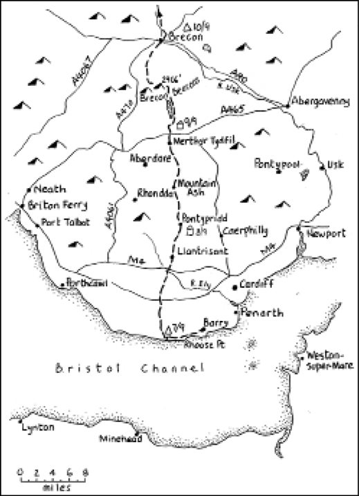
Barry to Brecon
It is about eight miles, mostly by footpath, along the coast around Rhoose Point to the St Athans youth hostel. The coastline is interesting, where industry is mixed up with countryside: deserted quarry workings, sea, beaches, cliffs and a power station. Just outside Barry the path passed by the Bulwarks, the site of a Roman fort where it is reputed the legions first landed in Wales .
The hostel was clean, friendly and, though designated as simple grade, provided good facilities for visitors. The prefabricated building is sited under the tall chimneys of a cement works which dominates the immediate surroundings, its dust covering everything with a uniform greyness. It is also next to the boys village, built in the early 1920s to help Welsh youngsters in the Boys Club movement. Nowadays, while still working for the original objectives, the village caters for any bona fide group who want to use its premises.
Monday 8th September; the Vale of Glamorgan
It poured with rain during the night but the weather had improved by the time I got away at eight oclock, to work my way across the Vale towards the Rhondda. The footpaths were the usual mixture of barbed wire, rotting gates, brambles, overhanging trees providing shower baths at suitable intervals and wet grass soaked through my boots. Though most paths were well signposted at their start, along their length it was often a complete guess as to which of the various farm fields to enter. And so inevitably there was a certain amount of backtrackingfull marks will be awarded to any conservation corps if they get down to maintaining these rights of way.
My route passed through Hensol Hospital, an institute for patients who suffered from learning difficulties, Downs syndrome and hydrocephalus. One of the patients came up to me and asked: Can I buy you a cup of coffee? adding by way of explanation, Ive just been paid. We went into the caf, his money burning a hole in his pocket. What would you like to eat? So I was soon having an unexpected midday snack, joined by a number of his fellow patients who kept asking me for cigarettes. My new-found friend, the brightest of those who joined us, reminded me several times how good it was of him to buy me a drink. When I asked him whether they played football he said, No, they wont let usthere are too many headers around here.!
Next page
