Val Ross - The Road to There. Mapmakers and Their Stories
Here you can read online Val Ross - The Road to There. Mapmakers and Their Stories full text of the book (entire story) in english for free. Download pdf and epub, get meaning, cover and reviews about this ebook. year: 2003, publisher: Random House;Tundra;Tundra Books, genre: History. Description of the work, (preface) as well as reviews are available. Best literature library LitArk.com created for fans of good reading and offers a wide selection of genres:
Romance novel
Science fiction
Adventure
Detective
Science
History
Home and family
Prose
Art
Politics
Computer
Non-fiction
Religion
Business
Children
Humor
Choose a favorite category and find really read worthwhile books. Enjoy immersion in the world of imagination, feel the emotions of the characters or learn something new for yourself, make an fascinating discovery.

The Road to There. Mapmakers and Their Stories: summary, description and annotation
We offer to read an annotation, description, summary or preface (depends on what the author of the book "The Road to There. Mapmakers and Their Stories" wrote himself). If you haven't found the necessary information about the book — write in the comments, we will try to find it.
Winner of the 2004 Norma Fleck Award for Canadian childrens non-fiction
Honor Book for the Society of School Librarians Internationals Best Book Award -- Social Studies, Grades 7-12
Shortlisted for the Childrens Literature Roundtable Information Book of the Year
2003 winner of the Mr. Christies Book Award Seal
Shortlisted for the 2004 Norma Fleck Award for Canadian Childrens Non-fiction
Included on VOYAs ninth annual Nonfiction Honor List
Selected for inclusion in CCBC Choices 2004:the best-of-the-year list published by the Cooperative Childrens Book center of the School of Education at the University of Wisconsin-Madison
Named Notable Book by the International Reading Associations Childrens Book Award in the intermediate nonfiction category
Road maps; sailors charts; quilts; songlines; gilded parchment covered with jewel-like colors; computer printouts -- to...
Val Ross: author's other books
Who wrote The Road to There. Mapmakers and Their Stories? Find out the surname, the name of the author of the book and a list of all author's works by series.


The Road to There. Mapmakers and Their Stories — read online for free the complete book (whole text) full work
Below is the text of the book, divided by pages. System saving the place of the last page read, allows you to conveniently read the book "The Road to There. Mapmakers and Their Stories" online for free, without having to search again every time where you left off. Put a bookmark, and you can go to the page where you finished reading at any time.
Font size:
Interval:
Bookmark:

This book is for Jack, who loved to draw maps,
for Erma, who gave me the compass I rely on,
and for the Mappers: Max, Maddie, Zoe,
and of course Morton.

13.
M iddle Earth and Mordor exist only in the imagination. Thats also where youll find Lilliput, Treasure Island, Oz, Ruritania, Jurassic Park, and Sim City. You cant walk to these places, yet there are detailed maps of all of them.
When I was young, the medieval-looking maps in C.S. Lewiss Narnia books inspired me to draw geographies of my own private worlds, with cities that went to war and great seas crossed by gallant sailing ships. I drew these maps in colored pencil; now I might use a computer.
There are many kinds of maps: maps that try to represent land according to mathematical principles; simplified diagrams; and descriptions of the landscape in story and song.
But all mapmaking, even the most scientific, involves some degree of imagination. Mapmakers make one country pink, another yellow. They throw a net over the world and call it lines of latitude and longitude. Now mapmakers are trying to tame and name other planets and solar systems.
So maps are more than a means of showing the lines around your property or your country. They give public names to regions that are mysterious. They create the sense that there are routes from Here to There (even if There is in outer space or our own imaginations). They are another way that we can tell stories.
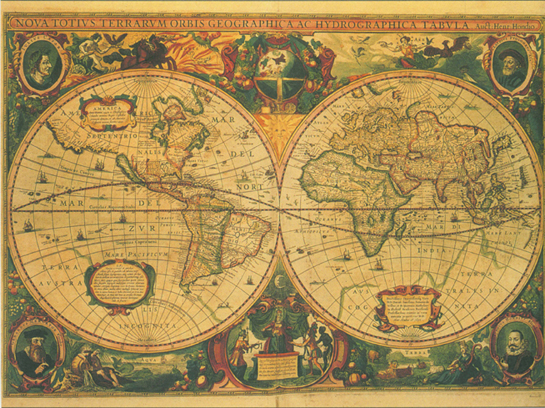
In 1633, Henricus Hondius published this world map based on the 1595 edition of the Mercator Atlas.

T HE M APMAKERS S ECRET I DENTITY
SOME TIME IN the first half of the 20th century, someone picks up a pen and begins to fake an antique map. The forgery will prove that the Norsemen, or Vikings, had sailed across the Atlantic Ocean to America long before Christopher Columbuss arrival in 1492.
The forgers pen hovers for a moment above a blank piece of parchment (animal skin prepared as a writing surface). The parchment is no fake. And, although it dates from about 1440 long after the Norse voyages to Wineland or Vinland (the Norse name for North America) around the year 1000 the forger is not worried, since many mapmakers based their maps on earlier maps. What is important is that his map will seem to predate Columbus.
The forger works carefully, writing in Latin and watering his ink so it will appear faded. He knows that medieval mapmakers used inks mixed from iron compounds that erode and leave a rusty stain, and plans to fake such stains with yellowish dye. He might even add holes to the parchment, to make it look like it was eaten by bookworms.
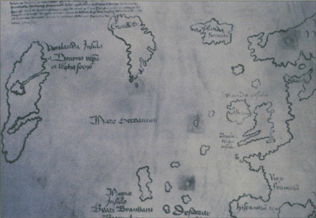
He draws the Mediterranean Sea, Northern Europe, Iceland, and Greenland. Then he dips his pen again, pauses, and commits himself to making the squiggly line that will turn his map into front-page headlines. Beyond Greenland, he draws a line showing the east coast of North America.
He adds notes to his map. One mentions the discovery of a new land, extremely fertile and having vines by the Norseman Leif Eriksson. Another note tells of a journey to Vinland around 11oo by Bishop Eirik Gnupsson of Greenland, who claimed the new land for the Holy Church.
The forger knows a lot about mapmakers of the past. He knows that the first map to use the word America was drawn by a German priest named Martin Waldseemller in 1507. And he knows that any map older than Waldseemllers that shows North America will be a cartographic bombshell.
The Vinland Map is almost certainly a fake. You can see Vinlanda where Baffin Island or Labrador would be, in the upper left. The parchment dates from around 1440, but the ink seems to be from the 20th century.
I n 1957, book dealers tried to sell a Vinland Map to the British Museum in London. The map they offered was bound into an old book about an Italian priests travels to Mongolia. The British Museum experts took a look at the book. They thought the Italian priest part looked genuine. But as for the Vinland Map they smelled a rat and said, No, thank you.
So the book dealers decided to unload their Vinland Map in North America. This time, the map convinced people perhaps because people were ready to be convinced. Scholars had speculated for some time that the Norse had beat Columbus to America because old Icelandic sagas, such as the Greenland Saga and Erik the Reds Saga, described voyages to Vinland around the year 1000. In the late 1950s, archeologists announced that they had found ruins of the Vinland settlement in northern Newfoundland.
North Americans were ready for some hold-in-your-hand proof of the Norse presence in North America. When the book dealers offered the map for sale in North America, a billionaire named Paul Mellon snapped it up for $1 million and donated it to Yale University.
The map was made public in November 1965, just before Columbus Day. This was bad timing for Italian and Spanish Americans who took pride in Columbus, the Italian who had sailed for Spain. They felt it was rude to steal Columbuss thunder, and joined the chorus of English scientists who were already crying Fake!
In 1966 the Smithsonian Institution in Washington DC invited experts from all over the world to stop fighting and calmly discuss the maps authenticity. The assembled experts began by questioning the book dealer who sold the map to Paul Mellon. He refused to reveal his sources, but this was not unusual. During World War II, the Nazis had stolen art and book collections from people in countries they conquered. These art objects found their way to dealers after the war. Dealers were reluctant to reveal too much about where their treasures came from, in case the original owners reclaimed them. All the Vinland Map conference could get from the book dealer was that he had acquired the map from a private European collector.
VIKINGS IN VINLAND
Viking poets began to sing the sagas of North American discovery shortly after the year 1000. These heroic poems tell of how warriors led by Bjarni Herjolfsson set off westward from Iceland, checked direction by sighting the stars along their arms, and trusted their single-sail open boats, or knarrs, to get them to Greenland. Instead the winds blew them off course to a new land. From their ships, Bjarni and his men could see tall forests. Fifteen years later, Leif Eriksson followed Bjarnis route and landed with thirty-five colonists. They called the place Vinland because they found fruit probably Newfoundlands sweet berries from which they could make wine.
Font size:
Interval:
Bookmark:
Similar books «The Road to There. Mapmakers and Their Stories»
Look at similar books to The Road to There. Mapmakers and Their Stories. We have selected literature similar in name and meaning in the hope of providing readers with more options to find new, interesting, not yet read works.
Discussion, reviews of the book The Road to There. Mapmakers and Their Stories and just readers' own opinions. Leave your comments, write what you think about the work, its meaning or the main characters. Specify what exactly you liked and what you didn't like, and why you think so.