ACKNOWLEDGEMENTS
Since 1985, when A Pocket Guide to the Carriage Roads was first published, through the publication of this new expanded edition, I have received assistance and support from many individuals. The person, however, to whom I am most indebted is bunny LaDouceur. Like me, bunny loves the carriage roads and has spent many enjoyable hours wandering them. bunny also possesses the talent and training to create accurate maps that are easy to follow. For this, as well as her enthusiastic and enduring loyalty to this project, I am truly grateful.
Others who have provided assistance, advice, support, and just plain hard labor include: Earl brechlin, John Clark, Judy Hazen Connery, Dan Kane, bob Rothe, Gary Stellpflug, Lois Winter, Karin Womer, and my family Andrea, Leif, and Joe Abrell. Thanks so much.
Original Text Copyright 1985, 1995 by Diana F. Abrell
New History of the Carriage Roads 2011 by Andrew Vietze
ISBN: 978-0-89272-924-1

Camden, ME
Courtesy and Safety
Bicyclists should not ride at excessive speeds. The carriage roads are designed to provide an opportunity for gentle recreation and communion with nature for everyone. Stay to the right and pass on the left only after giving a clear warning.
Horses are unpredictable , powerful creatures and should be approached with caution. Bicyclists should prepare to stop and await instructions before passing horses and carriages, especially when passing from behind. Do not attempt to touch horses, as they may be easily startled.
Carry water at all times of the year when planning to go more than a mile or two. Dehydration occurs just as easily in cold weather as in warm.
Begin cross-country ski trips early in the day. It becomes dark by 4:30 p.m. between November and February. Cross-country skiers will appreciate the thoughtfulness of those who refrain from walking in ski tracks.
During the peak season, parking areas at popular carriage road loops are often completely filled. The resulting overflow parking along the paved roads can create potentially hazardous conditions for pedestrians. Please be cautious when walking between cars or crossing the road on foot.
Carriage roads are easily damaged in wet weather and may be closed briefly during the spring or at other times. Check ahead with park headquarters (207-288-3338).
Eagle Lake Loop
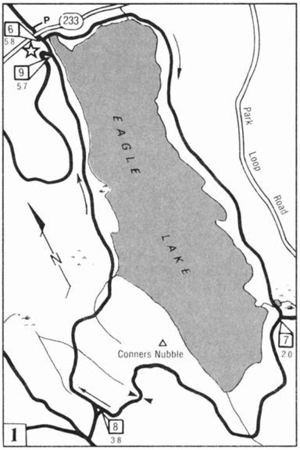
One of the most popular outings in Acadia National Park is the nearly six-mile loop around Eagle Lake. This loop is surfaced with fine gravel so that it is especially suitable for bicycles as well as wheelchairs and strollers. Horses are not allowed on this loop.
Park your car in the Eagle Lake parking area about three miles west of Bar Harbor on Rte. Walk west along the foot trail to where you can turn left and go under Rte. Turn left at (6). The first two miles are very level. A long, gradual ascent begins after you turn right at (7). The road reaches its crest just east of (8). The descent is again long and gradual, making especially excellent terrain for beginning cross-country skiers.
Bikers and skiers may prefer to travel in the opposite direction to take advantage of the relatively gentle rise along the west side of the lake rather than trying to negotiate the steeper climb from (7) to (8).
Aunt Bettys Pond Loop
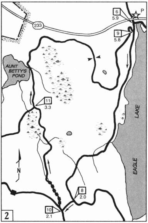
Aunt Bettys Pond Loop is unique not only for its unusual place names but also because the pond is the largest on Mt. Desert Island to which there is not vehicle access. If you see a canoe on this pond, its been carried in.
After parking your car in the Eagle Lake parking lot about three miles west of Bar Harbor on Rte. 233, walk west along the footpath to where you can turn left. Go under Rte. 233, and at [6] continue straight along the west side of Eagle Lake. The first mile is flat, but the second climbs to 468 feet at [8]. Turn right here. At [10] the carriage roads intersect in a K shape. Stay to the right.
If youre skiing, the fun starts now. The carriage road twists and turns as it drops steeply, crossing a meandering stream over six little bridges. The crossings are known as Seven Bridges. Old-timers say the seven bridges actually include a culvert below the six structures.
The long descent ends near Gilmore Meadow, which youll see on your left. Stay to the right at [11]. Aunt Bettys Pond, shallow and marshy, appears on the left. Exactly who Aunt Betty was is still unclear to historians. The name can be found on maps dating back to 1890.
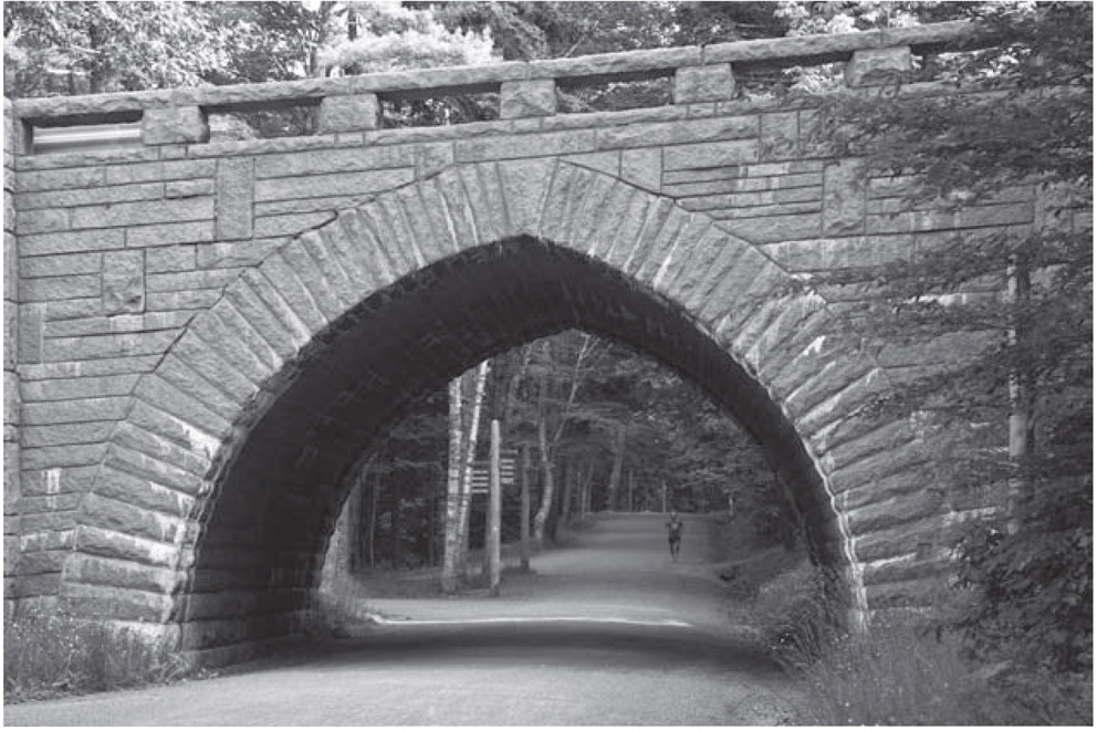
Leaving the pond, the carriage road rises from the marshy lowlands to an elevation where the views of the pond and of Eagle Lake and Cadillac Mountain are magnificent. At [9] turn left to return to your car.
Witch Hole Pond Loop
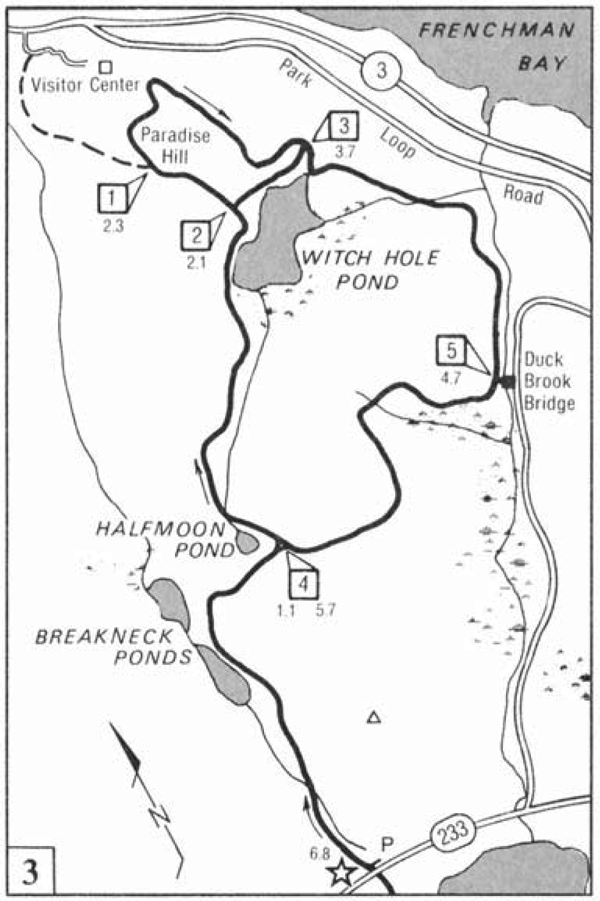
The Witch Hole Pond Loop can be reached from three points. This map shows access from the Eagle Lake parking lot three miles west of Bar Harbor on Rte.
In addition, however, you can park at the Acadia National Park Visitor Center in Hulls Cove and walk the one-half-mile path where it joins the Paradise Hill portion of the loop.


