Your Guide to Acadia National Park, First Edition (electronic)
ISBN: 978-1-62128-001-9
Published by: Stone Road Press
Author/Cartographer/Photographer/Designer: Michael Joseph Oswald
Editor: Derek Pankratz
Copyright 2012 Stone Road Press, LLC, Whitelaw, Wisconsin. All rights reserved. No part of this publication may be reproduced, stored in a retrieval system or transmitted in any form or by any means, electronic, mechanical, photocopying, recording, scanning or otherwise without written permission of the Publisher. Requests for permission should be addressed to Stone Road Press; c/o Michael Oswald; 4927 Stone Road; Whitelaw, WI 54247.
The entire work, Your Guide to the National Parks is available in paperback and electronic versions. Content that appears in print may not be available electronically.
Paperback ISBN: 978-1-62128-000-2
Library of Congress Control Number (LCCN): 2012934277
Printed in the United States of America
E-Book ISBN: 978-1-62128-065-1
Corrections/Contact
This guide book has been researched and written with the greatest attention to detail in order to provide you with the most accurate and pertinent information. Unfortunately, travel informationespecially pricingis subject to change and inadvertent errors and omissions do occur. Should you encounter a change, error, or omission while using this guide book, wed like to hear about it. (If you found a wonderful place, trail, or activity not mentioned, wed love to hear about that too.) Please contact us by sending an e-mail to . Your contributions will help make future editions better than the last.
You can contact us online at www.StoneRoadPress.com or follow us on
Facebook: www.facebook.com/thestoneroadpress
Twitter: www.twitter.com/stoneroadpress (@stoneroadpress)
Flickr: www.flickr.com/photos/stoneroadpress
FAQs
The world of electronic media is not cut and dry like print. Devices handle files differently. Users have a variety of expectations. These e-books are image- and map-intensive, requiring fairly powerful hardware. All books were tested for use on the Kindle Fire, Nook Tablet, and iPad. You can expect to have the best user experience on one of these devices, or a similar tablet, laptop, or desktop. In the event you have issues please peruse our Frequently Asked Questions (.
Maps
Numerous map layouts were explored while developing this e-book, but in the end it was decided that the most useful map is a complete one. Unfortunately, due to file size concerns and e-reader hardware limitations, some maps included in this guide book are below our usual high standards of quality (even using zoom features). As a workaround all of this books maps are available in pdf format by clicking the link below each map or visiting www.stoneroadpress.com/national-parks/maps .
Disclaimer
Your safety is important to us. If any activity is beyond your ability or threatened by forces outside your control, do not attempt it. The maps in this book, although accurate and to scale, are not intended for hiking. Serious hikers should purchase a detailed, waterproof, topographical map. It is also suggested that you write or call in advance to confirm information when it matters most.
The primary purpose of this guide book is to enhance our readers national park experiences, but the author, editor, and publisher cannot be held responsible for any experiences while traveling.
Photo Credits
Front cover: Yawning Fox Pat Hawks
Acadia - Introduction
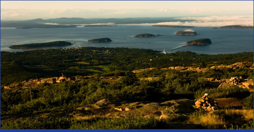
Frenchman Bay, the Porcupine Islands, and Bar Harbor as seen from Cadillac Mountain guillenperez 2009
The coast of Maine and Mount Desert Island (MDI) has an allure, a gravity that inexplicably draws people away from their big city life and frantic lifestyles. Here time slows down; visitors are given the chance to enjoy the little things that often go unnoticed. Nature is heard. Waves cracking against granite cliffs. A bullfrogs guttural croak. The rat-a-tat-tat of a woodpecker. A choir of singing sparrows. While it can feel like your first time truly experiencing nature, todays tourists are far from the first to enjoy the beauty of Maines Atlantic Coast. The deep blue lakes, bald granite mountaintops, and surf splashed cliffs of Acadia National Park have been treasured for more than a century.
About 25,000 years ago MDI wasnt even an island. It was continental mainland, occupied by a massive sheet of ice. The ice receded, but not without leaving a number of visible marks. Somes Sound, the only fjord along the U.S. Atlantic Coast, was carved by slow moving glacial ice, then submerged when it melted. Bubble Rock , a 14-ton glacial erratic, was carried 19 miles from its original resting place to be deposited precariously at the top of South Bubble . As the ice melted, water poured down the slopes of the recently shaved mountaintops; lakebeds were filled, the seas rose, and as the coast drowned in melt water an island was formed.
Long after glaciers covered the coast, the Abenaki people used the island as their seasonal home. A home they called Pemetic or the sloping land. Food was abundant. Fishing and hunting were relatively simple. Shellfish, plants, and berries were easily gathered. For the Abenaki people, life was good along the coast of Maine. It also was an appropriate home for the Abenaki or People of the Dawn: Cadillac Mountain on MDI, the tallest peak along the U.S. Atlantic Coast, is the first place in the continental U.S. to experience dawn.
In 1604, Samuel de Champlain spotted the barren peak of Cadillac Mountain from his ship. Not noticing the forested hills around it, he declared the island lIsle des Monts Dserts or the island of the bare mountains. The island may as well have been barren for the next 150 years as nations quarreled over the region. It passed hands several times between Natives, French, English, and Americans, but was never permanently occupied and seldom visited.
Thomas Cole and Frederic Church , painters from the Hudson River School, helped rediscover MDI in the mid-19 th century. Their work of the region helped bring the island into the public eye. At first, artists, professors, and other intellectuals known as rusticators made the multi-day journey here. These travellers required little in terms of accommodations as they hiked from place to place enjoying the areas simple lifestyle and sublime beauty.
Not long after the rusticators exposed MDIs beauty, developers were clamoring to increase access to the island. Direct steamboat service from Boston was offered in the 1860s. A rail line was completed in the 1880s. By this time MDI was the place to be for the East Coasts elite. Some of the wealthiest visitors, known locally as cottagers, purchased large tracts of land where they built lavish summer homes they ironically referred to as cottages. A stretch of mansions near Bar Harbor commonly called Millionaires Row burned to the ground during the great fire of 1947. The inferno razed more than 17,000 acres, including 10,000 acres of park land, before blowing into the Atlantic.
Still, development was MDIs main threat, not nature. Residents felt that its scenic beauty needed to be protected. John D. Rockefeller, Jr. and George B. Dorr , both cottagers turned conservationists, were two of the parks greatest advocates. Rockefeller built 57 miles of carriage roads, donated thousands of acres of land, and spent $3.5 million on the potential park. Dorr blazed trails, donated land, and became the parks first superintendent. Acadia National Park was eventually created, cobbled together entirely from private donations. It successfully protected some of the areas most rugged shorelines and beautiful landscapes for the enjoyment of the people.
Next page

