Best Easy Day Hikes Series
Best Easy Day Hikes Shenandoah National Park
Fourth Edition
Bert and Jane Gildart
Help Us Keep This Guide Up to Date
Every effort has been made by the authors and editors to make this guide as accurate and useful as possible. However, many things can change after a guide is publishedtrails are rerouted, regulations change, facilities come under new management, etc.
We would appreciate hearing from you concerning your experiences with this guide and how you feel it could be improved and kept up to date. While we may not be able to respond to all comments and suggestions, well take them to heart and well also make certain to share them with the authors. Please send your comments and suggestions to the following address:
GPP
Reader Response/Editorial Department
P.O. Box 480
Guilford, CT 06437
Or you may e-mail us at:
editorial@GlobePequot.com
Thanks for your input, and happy trails!
Copyright 2002, 2006, 2011 by Morris Book Publishing, LLC
A previous edition of this book was published by Falcon Publishing, Inc. in 1998.
ALL RIGHTS RESERVED. No part of this book may be reproduced or transmitted in any form by any means, electronic or mechanical, including photocopying and recording, or by any information storage and retrieval system, except as may be expressly permitted in writing from the publisher. Requests for permission should be addressed to Globe Pequot Press, Attn: Rights and Permissions Department, P.O. Box 480, Guilford, CT 06437.
FalconGuides is an imprint of Globe Pequot Press.
Falcon, FalconGuides, and Outfit Your Mind are registered trademarks of Morris Book Publishing, LLC.
Maps by XNR Productions, Ltd. Morris Book Publishing LLC
TOPO! Explorer software and SuperQuad source maps courtesy of National Geographic Maps. For information about TOPO! Explorer, TOPO!, and Nat Geo Maps products, go to www.topo.com or www
.natgeomaps.com.
ISBN 978-0-7627-6432-7
The authors and Globe Pequot Press assume no liability for accidents happening to, or injuries sustained by, readers who engage in the activities described in this book.
Contents
The Hikes
Acknowledgments
No book is ever written and completed without the help of others, and this guide is no exception. First, wed like to thank Steve Bair and Melissa Rudacille, both park rangers at Shenandoah National Park who reviewed the book and provided much valuable information. We attempted to incorporate all of their thoughts, suggestions, and ideas and hope we have interpreted their comments correctly. As well, wed like to thank Greta Miller, director of the Shenandoah National Park Association, and Dan Hurlbert, the parks map specialist who simplified the verification of GPS coordinates with map overlays. Greta aided with initial logistics and helped us establish just what direction our work would follow.
Along the trails we met the South District Trail Crew, who offered much good trailside chat and helped explain new Shenandoah backcountry policy. Thanks as well to former ranger and adventurer Buck Hisey, now of the Shenandoah Valley, and his wife, Fran (also an adventurer extraordinaire), for their spontaneous friendship, meals, and long night of information about Shenandoah.
We want to thank Adam and Susan Maffei for companionship in 2010 as we rehiked many of the parks trails. They are special friends and quintessential hikers. We also want to thank Julie Marsh who has helped us not only with this publication but several other FalconGuides as well. She has an eagle eye and the patience of Job.
Last, our thanks to Bill Schneider, founder of Falcon Press, who got us to Shenandoah way back in 1998, and to Jessica Haberman of Globe Pequot Press who got us back more than a decade later.
Introduction
Shenandoah National Park straddles a beautiful stretch of the Blue Ridge, which forms the eastern rampart of the Appalachian Mountains. Beginning in the late 1700s, settlers began drifting into these hills and hollers. They cleared some of the vast forests that originally blanketed the region so that they could till the land. Shenandoah was established as a national park in 1935. For the most part, the forests reestablished naturally. As the flora returned, so did Shenandoahs fauna. Today, some 200 species of birds occupy the park, as well as around 50 species of mammals, some of which had declined significantly in number prior to the parks establishment.
Today, Shenandoah offers a little something for everyone with an interest in the out-of-doors. The park attracts more than a million visitors annually and, to accommodate these crowds, is open twenty-four hours a day, seven days a week unless the roads are closed due to ice, snow or fog. Two visitor centers, Dickey Ridge in the North District and Byrd Visitor Center at Big Meadows, are open seven days a week from 8:30 a.m. to 5:00 p.m. beginning about the first of April and usually closing in late November. For current park information call headquarters at (540) 999-3500, or write Shenandoah National Park, 3655 US Highway 211 E, Luray, VA 22835; or visit www
.nps.gov/shen.
As a further means of accommodating visitors, the park has four public campgrounds with a total of 660 campsites. Big Meadow closes at the end of November, while the other three close October 31. No hookups for RVs, but water and dump stations are available as well as bathrooms. Propane and diesel fuel are not available in the park, only in surrounding towns.
In some of the campgrounds, sites are allocated on a first-come, first-served basis. Getting a spot can be difficult, particularly in the summer and in the fall, when autumn foliage peaks. At Big Meadows Campground, make reservations for mid-May through October. Even if you arrive during the week, and get a spot, there is some chance you might have to move as the weekend rolls around, because visitors with reservations have priority.
Dogs on a 6-foot leash are allowed on most trails throughout the park. For those few trails that do not permit dogs, see Canine compatibility for each hike.
Though Shenandoah offers many attractions, hikes to the waterfalls and highest peaks remain among the most popular. Fortunately, access to these most scenic of attractions is relatively easy.
Getting There
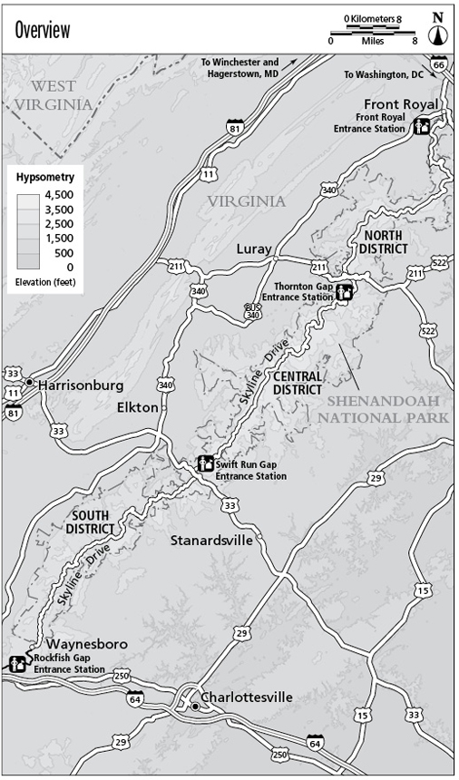
Shenandoah is easily accessible from a variety of different locales. In the north, you can access the park via Front Royal, Virginia, by leaving US 340 south of town and following the bold and abundant signs to the parks entrance. From the highway, the parks northern entrance station is less than a mile away.
From the south, you can access the park by driving from Waynesboro via US 250 to the Rockfish Gap entrance station. You can also enter at its Thornton Gap entrance, 30 miles farther north, via US 211. If you are coming through Harrisonburg to the west or Stanardsville to the east, you can enter on US 33 at the Swift Run Gap entrance. From Charlottesville and Richmond, you can take I-64 west to Rockfish Gap, the parks southernmost entrance.
Once in the park, you will drive the famous Skyline Drive. Along the west side of this 105.4-mile route, the park has conveniently placed mile markers. Because almost all trails radiate from Skyline Drive, its very simple to find your desired trailhead. The mileposts begin just after the north entrance of the park, accessed from the town of Front Royal. The last marker, Milepost 105.4, is located at Rockfish Gap in the south. From here, the Blue Ridge Parkway continues south; the town of Waynesboro is at the base of the mountains as you leave the park.


