About the Author
Mike Wells is an author of both walking and cycling guides. He has been walking long-distance footpaths for 25 years, after a holiday in New Zealand gave him the long-distance walking bug. Within a few years, he had walked the major British trails, enjoying their range of terrain from straightforward downland tracks through to upland paths and challenging mountain routes. He then ventured into France, walking sections of the Grande Randonne network (including the GR5 through the Alps from Lake Geneva to the Mediterranean), and Italy to explore the Dolomites Alta Via routes. Further afield, he has walked in Poland, Slovakia, Slovenia, Norway and Patagonia.
Mike has also been a keen cyclist for over 20 years. After completing various UK Sustrans routes, such as Ln Las Cymru in Wales and the C2C route across northern England, he then moved on to cycling long-distance routes in continental Europe and beyond. These include cycling both the Camino and Ruta de la Plata to Santiago de la Compostela, a traverse of Cuba from end to end, a circumnavigation of Iceland and a trip across Lapland to the North Cape. He has written a series of cycling guides for Cicerone following the great rivers of Europe.
Other Cicerone guides by the author
The Adlerweg
The Rhine Cycle Route
The Moselle Cycle Route
The Danube Cycleway Volume 1
The Danube Cycleway Volume 2
The River Rhone Cycle Route
The Loire Cycle Route
Cycling London to Paris
CYCLING THE CAMINO DE SANTIAGO
THE WAY OF ST JAMES CAMINO FRANCS
by Mike Wells
JUNIPER HOUSE, MURLEY MOSS,
OXENHOLME ROAD, KENDAL, CUMBRIA LA9 7RL
www.cicerone.co.uk
Mike Wells 2019
First edition 2019
ISBN 9781783627103
Printed in China on behalf of Latitude Press Ltd
A catalogue record for this book is available from the British Library.
All photographs are by the author unless otherwise stated.
 Route mapping by Lovell Johns www.lovelljohns.com
Contains OpenStreetMap.org data OpenStreetMap contributors, CC-BY-SA. NASA relief data courtesy of ESRI
Updates to this Guide
While every effort is made by our authors to ensure the accuracy of guidebooks as they go to print, changes can occur during the lifetime of an edition. Any updates that we know of for this guide will be on the Cicerone website (www.cicerone.co.uk/969/updates), so please check before planning your trip. We also advise that you check information about such things as transport, accommodation and shops locally. Even rights of way can be altered over time.
The route maps in this guide are derived from publicly available data, databases and crowd-sourced data. As such they have not been through the detailed checking procedures that would generally be applied to a published map from an official mapping agency, although naturally we have reviewed them closely in the light of local knowledge as part of the preparation of this guide.
We are always grateful for information about any discrepancies between a guidebook and the facts on the ground, sent by email to updates@cicerone.co.uk or by post to Cicerone, Juniper House, Murley Moss, Oxenholme Road, Kendal, LA9 7RL.
Register your book : To sign up to receive free updates, special offers and GPX files where available, register your book at www.cicerone.co.uk.
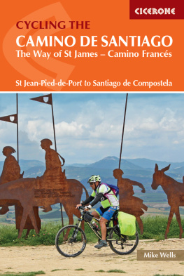
Front cover: The Alto del Perdn, where the path of the wind crosses that of the stars (Stage 3)
CONTENTS

Santa Mara church in Viana (Stage 4)
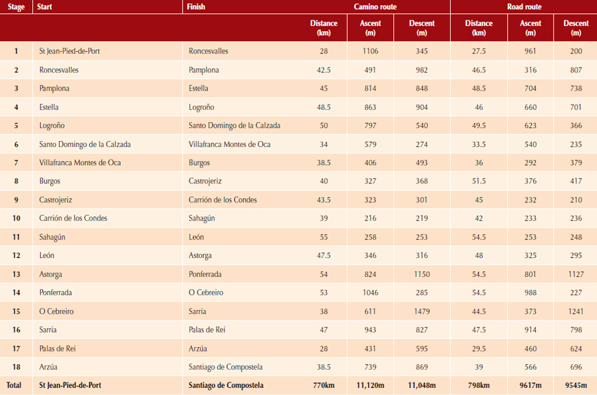
ROUTE SUMMARY TABLE

The kindly image of Santiago Peregrino over the Door of Pardon in Santiago cathedral (Stage 18)
INTRODUCTION
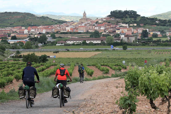
Navarrete in the Rioja wine region has 11 bodegas (wineries) (Stage 5)
When a ninth-century Galician shepherd found the long-buried body of the Apostle James in a remote corner of north-west Spain, he could not have envisaged that his discovery would lead to a huge pilgrimage with hundreds of thousands of people making their way every year across Europe to visit his find or that this pilgrimage would witness not one but two periods of popularity, with 500 years between them. The first pilgrimage, which ran between the ninth and sixteenth centuries was a hard journey. Medieval peregrinos (pilgrims) would travel thousands of kilometres to Santiago with no maps or guides, in basic clothing, braving the weather, dangerous animals, thieves and polluted drinking water to gain absolution from their sins by touching what believers claim to be the tomb of Santiago (St James), a disciple of Jesus Christ. When they reached Santiago, they had to turn around and retrace the hazardous journey. They could be away from home for up to a year, with no way of contacting family and friends. Significant numbers would never return home, some dying en-route and others settling down for a new life in northern Spain.
The journey is much easier for modern pilgrims. They can travel in weatherproof clothing on well-waymarked trails, drinking safely from countless drinking fountains that are tested frequently to guarantee water purity, with neither wolf, bear nor robber in sight. Every night they can stay in basic but comfortable albergues (pilgrim hostels) and consume good-value filling food and wine from pilgrim menus in a wide choice of restaurants. They can use mobile phones to call home every night and post online pictures of themselves on their journey. When they reach Santiago, they can fly home effortlessly in a few hours.
The degree of hardship may have changed, but the journey is still one of discovery, both of new places and of the inner self. The route followed may have altered slightly but it still has the same name, El Camino de Santiago (The Way of St James) or usually just The Camino. Medieval pilgrims either walked or travelled on horseback. Modern pilgrims still walk, but very few use a horse. Those that do ride nowadays favour a bicycle and take approximately two weeks to complete the journey across northern Spain from St Jean to Santiago and it is for these cycling pilgrims that this guide has been written.

Rich medieval pilgrims travelled on horseback, nowadays only a handful use animal power (Stage 5)
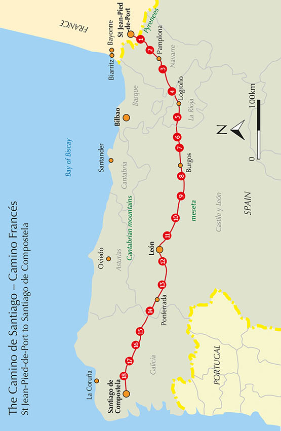
There is more than one pilgrim route to Santiago, but the most popular in medieval times and again today is the Camino Francs, named for the large number of French pilgrims who followed this route. Pilgrims started at many points throughout France or further afield, using different routes that converged upon St Jean-Pied-de-Port at the foot of the lowest and easiest pass over the Pyrenees into Spain. Their approximately 800km route from St Jean to Santiago follows a generally eastwest trajectory, south of and parallel with the Cantabrian mountains. Beyond the Pyrenees the trail undulates through Navarre then crosses the wine-producing region of Rioja. After steadily ascending then descending into Burgos, the route reaches and crosses the northern tip of the meseta, a vast area of rolling high-level chalk downland that occupies much of central Spain. After Len, the forested Montes de Len and fertile Bierzo basin are crossed before the rolling green hills and valleys of Galicia are reached. The Camino ends at the great religious city of Santiago de Compostela, where the tomb of St James housed inside an 11th-century cathedral is the ultimate destination of the pilgrimage.









 Route mapping by Lovell Johns www.lovelljohns.com
