About the Author
Paddy Dillon is a prolific walker and guidebook writer, with over 90 guidebooks to his name and contributions to 40 other titles. He has written extensively for many different outdoor publications and has appeared on radio and television.
Paddy uses a tablet computer to write his route descriptions while walking. His descriptions are therefore precise, having been written at the very point at which the reader uses them.
Paddy is an indefatigable long-distance walker who has walked all of Britains National Trails and several major European trails. He lives on the fringes of the Lake District and has walked, and written about walking, in every county throughout the British Isles. He has led guided walks and walked throughout Europe, as well as in Nepal, Tibet, Korea, Africa and the Rocky Mountains of Canada and the US. Paddy is a member of the Outdoor Writers and Photographers Guild.
Other Cicerone guides by the author
Glyndwrs Way
Mountain Walking in Mallorca
The Cleveland Way and the Yorkshire Wolds Way
The GR5 Trail
The GR20 Corsica
The Great Glen Way
The Irish Coast to Coast Walk
The Mountains of Ireland
The National Trails
The North York Moors
The Pennine Way
The Reivers Way
The South West Coast Path
The Teesdale Way (Martin Collins; updated by Paddy Dillon)
The Wales Coast Path
Trekking in Greenland the Arctic Circle Trail
Trekking in Mallorca
Trekking in the Alps (contributing author)
Walking and Trekking in Iceland
Walking in County Durham
Walking in Menorca
Walking in Sardinia
Walking in the Azores
Walking in the Isles of Scilly
Walking in the North Pennines
Walking on Arran
Walking on Gran Canaria
Walking on Guernsey
Walking on Jersey
Walking on La Gomera and El Hierro
Walking on Lanzarote and Fuerteventura
Walking on La Palma
Walking on Madeira
Walking on Malta
Walking on Tenerife
TREKKING IN THE CANARY ISLANDS
THE GR131 ISLAND-HOPPING ROUTE
by Paddy Dillon
JUNIPER HOUSE, MURLEY MOSS,
OXENHOLME ROAD, KENDAL, CUMBRIA LA9 7RL
www.cicerone.co.uk
Paddy Dillon 2020
First edition 2020
ISBN 9781783627967
Printed by KHL Printing, Singapore
A catalogue record for this book is available from the British Library.
 Route mapping by Lovell Johns www.lovelljohns.com
All photographs are by the author unless otherwise stated.
Contains OpenStreetMap.org data OpenStreetMap contributors, CC-BY-SA. NASA relief data courtesy of ESRI
Updates to this Guide
While every effort is made by our authors to ensure the accuracy of guidebooks as they go to print, changes can occur during the lifetime of an edition. Any updates that we know of for this guide will be on the Cicerone website (www.cicerone.co.uk/765/updates), so please check before planning your trip. We also advise that you check information about such things as transport, accommodation and shops locally. Even rights of way can be altered over time.
We are always grateful for information about any discrepancies between a guidebook and the facts on the ground, sent by email to updates@cicerone.co.uk or by post to Cicerone, Juniper House, Murley Moss, Oxenholme Road, Kendal, LA9 7RL.
Register your book: To sign up to receive free updates, special offers and GPX files where available, register your book at www.cicerone.co.uk.
Notes on mapping
The route maps in this guide are derived from publicly available data, databases and crowd-sourced data. As such they have not been through the detailed checking procedures that would generally be applied to a published map from an official mapping agency, although naturally we have reviewed them closely in the light of local knowledge as part of the preparation of this guide. The islands are densely forested in places, and there is extensive tree cover which may change over time although the woodland shown is reasonably representative it should not be considered completely accurate.
Front cover: Degollada de Gujara with El Teide beyond (Stage 23)
CONTENTS
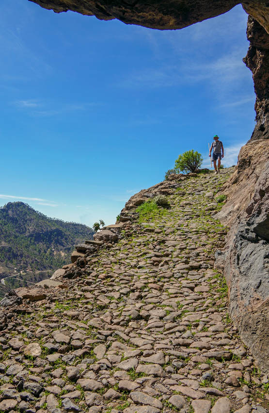
Rock overhangs a splendid paved path high above Cruz Grande (Stage 17)

Climbing past terraces in the Valle de Malpaso above Hara (Stage 2)
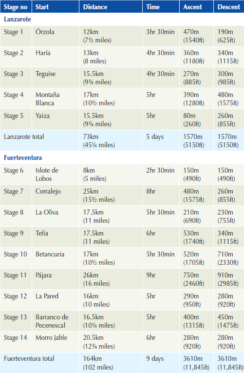
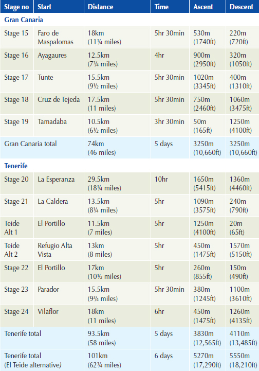
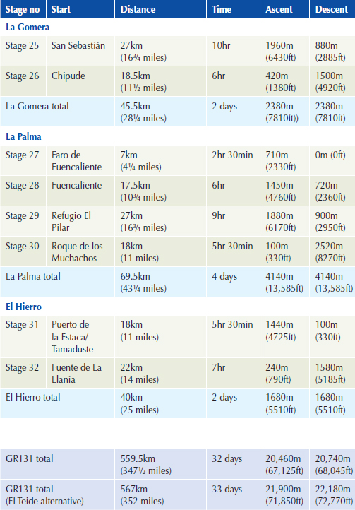
ROUTE SUMMARY TABLE
INTRODUCTION
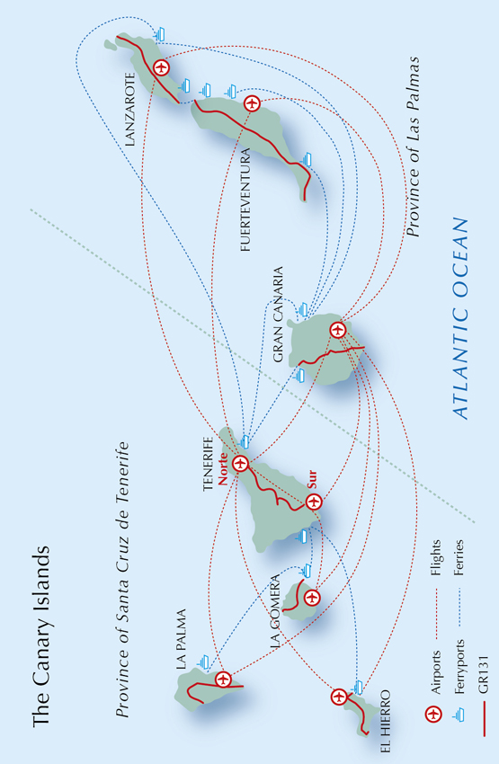
The Canary Islands comprise seven subtropical islands with enviable weather and a great variety of scenery. Who wouldnt want to trek all the way across them, one after another? There are rugged coastlines and occasional sandy beaches, arid slopes of aromatic scrub, steep and rugged mountains clothed in extensive pine forests and curious laurisilva cloud forests, with the possibility of snow-capped peaks rising even higher in the winter months. The GR131 is an island-hopping trail that runs coast to coast across each of the islands in turn and often seeks out the highest mountains during each traverse. It measures 560km (348 miles) and would take an average trekker about one month to complete.
The GR131 is described from east to west, starting on the arid, volcanic island of Lanzarote, later taking a short ferry ride to the desert-like Fuerteventura. A long ferry ride leads to Gran Canaria, where the mountains rise higher and feature extensive forests. Another ferry ride leads to Tenerife, where the GR131 stays high, featuring more forests, with even more rugged mountains rising above them. An option is presented to vary the route and include the mighty El Teide the highest mountain on Spanish territory. A short ferry ride to La Gomera sees the trail climb high into extensive laurisilva cloud forest. A longer ferry ride leads to La Palma, where the trail climbs high and stays on the highest mountains, offering a particularly tough traverse ending with a steep descent. The GR131 finally finds itself making a high-level traverse through the smallest and westernmost island of El Hierro, ending at a point that was once believed to be the edge of the world.







 Route mapping by Lovell Johns www.lovelljohns.com


