Chao Chen - Enabling Smart Urban Services with GPS Trajectory Data
Here you can read online Chao Chen - Enabling Smart Urban Services with GPS Trajectory Data full text of the book (entire story) in english for free. Download pdf and epub, get meaning, cover and reviews about this ebook. year: 2021, publisher: Springer, genre: Home and family. Description of the work, (preface) as well as reviews are available. Best literature library LitArk.com created for fans of good reading and offers a wide selection of genres:
Romance novel
Science fiction
Adventure
Detective
Science
History
Home and family
Prose
Art
Politics
Computer
Non-fiction
Religion
Business
Children
Humor
Choose a favorite category and find really read worthwhile books. Enjoy immersion in the world of imagination, feel the emotions of the characters or learn something new for yourself, make an fascinating discovery.

- Book:Enabling Smart Urban Services with GPS Trajectory Data
- Author:
- Publisher:Springer
- Genre:
- Year:2021
- Rating:4 / 5
- Favourites:Add to favourites
- Your mark:
Enabling Smart Urban Services with GPS Trajectory Data: summary, description and annotation
We offer to read an annotation, description, summary or preface (depends on what the author of the book "Enabling Smart Urban Services with GPS Trajectory Data" wrote himself). If you haven't found the necessary information about the book — write in the comments, we will try to find it.
With the proliferation of GPS devices in daily life, trajectory data that records where and when people move is now readily available on a large scale. As one of the most typical representatives, it has now become widely recognized that taxi trajectory data provides rich opportunities to enable promising smart urban services. Yet, a considerable gap still exists between the raw data available, and the extraction of actionable intelligence. This gap poses fundamental challenges on how we can achieve such intelligence. These challenges include inaccuracy issues, large data volumes to process, and sparse GPS data, to name but a few. Moreover, the movements of taxis and the leaving trajectory data are the result of a complex interplay between several parties, including drivers, passengers, travellers, urban planners, etc.
In this book, we present our latest findings on mining taxi GPS trajectory data to enable a number of smart urban services, and to bring us one step closer to the vision of smart mobility. Firstly, we focus on some fundamental issues in trajectory data mining and analytics, including data map-matching, data compression, and data protection. Secondly, driven by the real needs and the most common concerns of each party involved, we formulate each problem mathematically and propose novel data mining or machine learning methods to solve it. Extensive evaluations with real-world datasets are also provided, to demonstrate the effectiveness and efficiency of using trajectory data.
Unlike other books, which deal with people and goods transportation separately, this book also extends smart urban services to goods transportation by introducing the idea of crowdshipping, i.e., recruiting taxis to make package deliveries on the basis of real-time information. Since people and goods are two essential components of smart cities, we feel this extension is bot logical and essential. Lastly, we discuss the most important scientific problems and open issues in mining GPS trajectory data.
Chao Chen: author's other books
Who wrote Enabling Smart Urban Services with GPS Trajectory Data? Find out the surname, the name of the author of the book and a list of all author's works by series.


Enabling Smart Urban Services with GPS Trajectory Data — read online for free the complete book (whole text) full work
Below is the text of the book, divided by pages. System saving the place of the last page read, allows you to conveniently read the book "Enabling Smart Urban Services with GPS Trajectory Data" online for free, without having to search again every time where you left off. Put a bookmark, and you can go to the page where you finished reading at any time.
Font size:
Interval:
Bookmark:


This Springer imprint is published by the registered company Springer Nature Singapore Pte Ltd.
The registered company address is: 152 Beach Road, #21-01/04 Gateway East, Singapore 189721, Singapore
With the proliferation of GPS devices and wireless communication technologies in daily life, recent years have witnessed an increasing number of GPS-equipped vehicles, reporting their real-time moving locations to data centers continuously. On the other hand, due to convenience and speed, vehicles have become one of the most common transportation ways to move around the city. As a result, trajectory data that records where and when people move is now gathered and is readily available on a large scale, providing us a time-evolving view to understand how city transports from a data-driven perspective. Taxis movements, compared to other vehicles, are more complicated. Obviously, taxis trajectories contain richer information because their movements are affected not only by taxi drivers, but also by passengers, urban planners, etc. For instance, in a trip generation cycle, the heading destination is required by the passenger, while the taxi driver can make decisions on which route to deliver, and where to hunt for new passengers after arrivals. Whether taxis can move smoothly depends on the management efficiency of urban infrastructures by urban planners to a great degree. Generally, to provide various smart urban services for different beneficial parties, the very basic is to understand or model the individual and group/community human behaviors. In more detail, knowing how an individual behaves under various contexts can make the service provision more personalized; on the other hand, knowing how a group/community of people moves is able to understand the time-dependent traffic dynamics. What is more, their differences may correspond to some abnormal (e.g., detouring) or outstanding behaviors (e.g., efficient service strategy) of an individual. All kinds of behaviors and their differences are embedded and hidden behind the trajectory data, calling for new data mining and machine learning models. In one word, due to its richness and uniqueness, the research on mining trajectory data of moving taxis has attracted extensive attention from numerous scholars in the past decade.
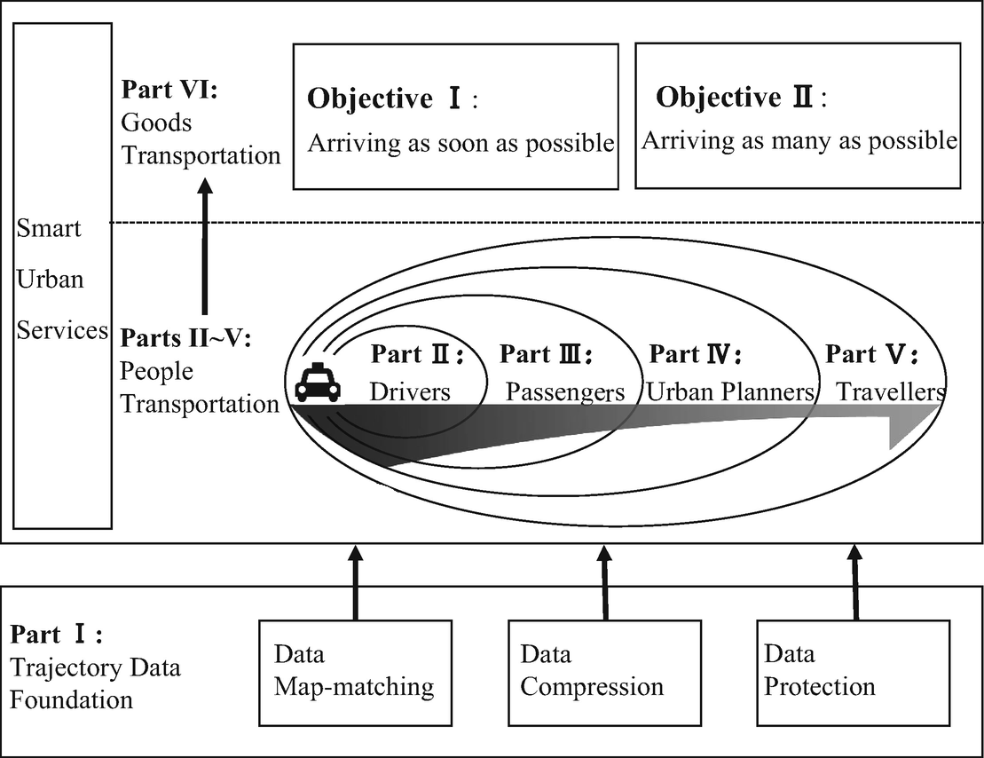
The structure of main parts in this monograph
In this monograph, we present our latest achievements on mining taxi GPS trajectory data to enable a number of smart urban services, and to bring us one step closer to the vision of smart mobility, concerning interests from the most-involved parties including taxi drivers, passengers to the little-involved parties like urban planners and travellers. The monograph is organized as follows, as shown in Fig.. Firstly, we focus on some fundamental issues in trajectory data mining and analytics, including data map-matching, data compression, and data protection. Secondly, driven by the real needs and the most common concerns of each involved party, we formulate each problem mathematically and propose novel data mining or machine learning methods to solve it. Multiple human behavior-related data including check-in data, POI data are also coupled and combined to gain more complete and detailed understanding about human mobility when necessary. Extensive evaluations with real-world datasets are also provided to demonstrate the effectiveness and efficiency of using trajectory data. Lastly, we discuss the most important scientific problems and open issues in mining GPS trajectory data. In summary, this monograph gradually introduces background, related research, new definitions and technologies for solving problems that beginners will encounter when entering this newly exciting research field.
This monograph differs from existing literatures in the following aspects. On the one hand, we focus on analyzing the GPS trajectory data particularly since such data is adequately representative of human behaviors contributed by multiple kinds of urban residents. Besides, we also intend to cover a wider and more complete range, from trajectory data map-matching, data compression, and data protection to data-driven smart urban services. We group the smart urban services into four categories according to the beneficial party, i.e., drivers, passengers, urban planners as well as travellers (as shown in the middle part of Fig. ). Beyond people transportation, we also extend smart urban services to goods transportation by introducing a novel idea of Crowdshipping, i.e., recruiting taxis to make package deliveries on the basis of real-time information. Since people and goods are two essential components of smart cities and their transportation shares the sufficient overlap (e.g., the same city infrastructure), we believe such extension is logical and essential.
Font size:
Interval:
Bookmark:
Similar books «Enabling Smart Urban Services with GPS Trajectory Data»
Look at similar books to Enabling Smart Urban Services with GPS Trajectory Data. We have selected literature similar in name and meaning in the hope of providing readers with more options to find new, interesting, not yet read works.
Discussion, reviews of the book Enabling Smart Urban Services with GPS Trajectory Data and just readers' own opinions. Leave your comments, write what you think about the work, its meaning or the main characters. Specify what exactly you liked and what you didn't like, and why you think so.