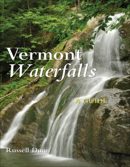
Russell Dunn - Vermont Waterfalls
Here you can read online Russell Dunn - Vermont Waterfalls full text of the book (entire story) in english for free. Download pdf and epub, get meaning, cover and reviews about this ebook. year: 2015, publisher: Countryman Press, genre: Home and family. Description of the work, (preface) as well as reviews are available. Best literature library LitArk.com created for fans of good reading and offers a wide selection of genres:
Romance novel
Science fiction
Adventure
Detective
Science
History
Home and family
Prose
Art
Politics
Computer
Non-fiction
Religion
Business
Children
Humor
Choose a favorite category and find really read worthwhile books. Enjoy immersion in the world of imagination, feel the emotions of the characters or learn something new for yourself, make an fascinating discovery.

- Book:Vermont Waterfalls
- Author:
- Publisher:Countryman Press
- Genre:
- Year:2015
- Rating:5 / 5
- Favourites:Add to favourites
- Your mark:
Vermont Waterfalls: summary, description and annotation
We offer to read an annotation, description, summary or preface (depends on what the author of the book "Vermont Waterfalls" wrote himself). If you haven't found the necessary information about the book — write in the comments, we will try to find it.
More than 200 waterfalls, from town centers to roadsides to isolated natural areas
For those who seek the special serenity that seems to be found near moving water, this guide to waterfalls in one of Americas most beautiful states will be a blissful find in itself. Vermont Waterfalls: A Guide is illustrated with appealing antique postcards of some of the states most famous falls as well as modern photographs of falls described here for the first time. Using the same successful geographic organization scheme employed in Connecticut Waterfalls: A Guide, the author makes it feasible to see several waterfalls in one trip. Detailed maps identify waterfalls by their proximity to Vermonts major roadways: US 7 in the west; route 100 bridging the center; and US5/I-91 to the east. With more than 200 entries that include the history of and directions to all these cataracts and cascades, this guide is meant for everyonewaterfall enthusiasts, photographers, hikers, artists, families . . .Russell Dunn: author's other books
Who wrote Vermont Waterfalls? Find out the surname, the name of the author of the book and a list of all author's works by series.

Vermont Waterfalls — read online for free the complete book (whole text) full work
Below is the text of the book, divided by pages. System saving the place of the last page read, allows you to conveniently read the book "Vermont Waterfalls" online for free, without having to search again every time where you left off. Put a bookmark, and you can go to the page where you finished reading at any time.
Font size:
Interval:
Bookmark:
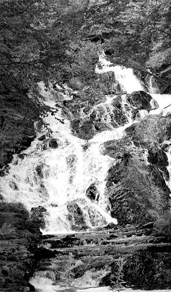
Jeudevine Falls, a privately owned waterfall park. (Photograph 2013)
A GUIDE

Russell Dunn

To Dean Goss, a fellow waterfall enthusiast and popularizer of waterfalls, not only in Vermont but worldwide; and to Michael and Christine Canavan, who opened up the wonders of Vermont to me.
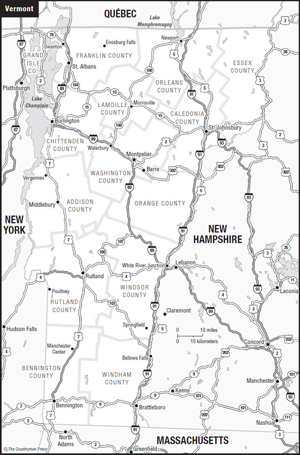
Western Vermont via US 7
US 7 runs southnorth through western Vermont for 176 miles. The highway begins in Pownal and ends north of Highgate, just south of the Canadian border. Generally, the road remains level and straight, keeping to the Valley and Lowlands regions. It also passes through some substantial-sized cities, such as Rutland and Burlington, as well as some medium-sized communities like Middlebury, Winooski, St. Albans, and Swanton. Historic Route 7A (also known as the Ethan Allen Highway) provides an alternative route for accessing waterfalls between Bennington and Dorset.
Also worth mentioning is VT 9, the Molly Stark Trail, which goes eastwest from Bennington (US 7), through Wilmington (VT 100), to Brattleboro (I-91 and US 5), crossing the south end of Vermont. The highway is named after Molly Stark (also known as Elizabeth Page Stark), wife of John Stark of Revolutionary War fame.
There are five counties covered in this section:
 Addison County
Bennington County
Chittenden County
Franklin County
Rutland County
Location: North of North Pownal (Bennington County)
DeLorme Vermont Atlas and Gazetteer: p. 20, I56
GPS: 4249.635N 7315.386W
Views: Lateral and head-on
Aesthetics: Excellent
Characteristics: Rural, scenic, medium-sized
Accessibility: 0.1-mile hike
Degree of Difficulty: To top of main fallsmoderately easy; to bottom of main fallsmoderately difficult
DESCRIPTION: The Upper Tubs consists of a series of cascades and flumes formed on Wash Tub Brooka secondary stream that rises in the hills northeast of North Pownal and flows into the Hoosic River northeast of Pownal.
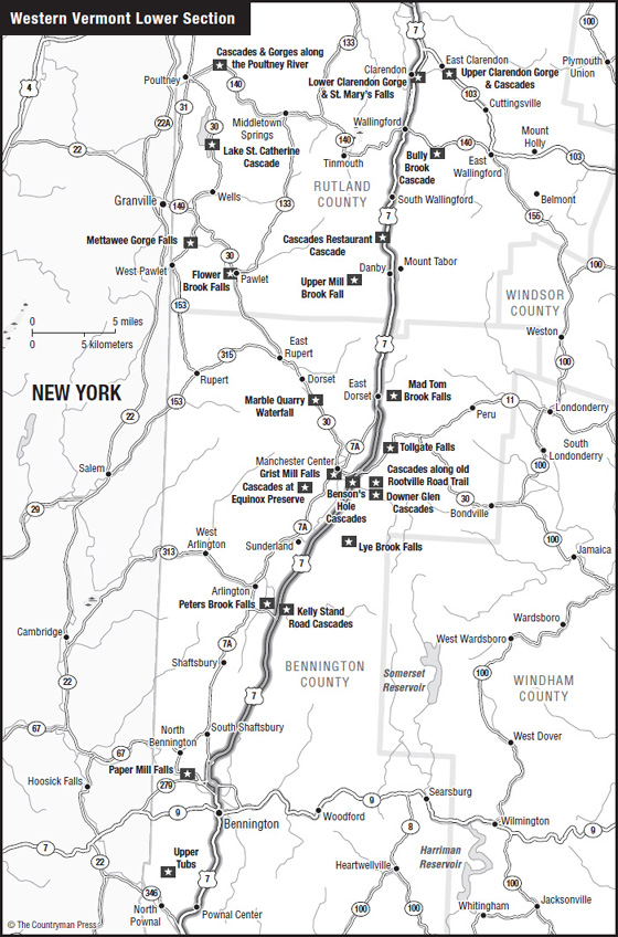
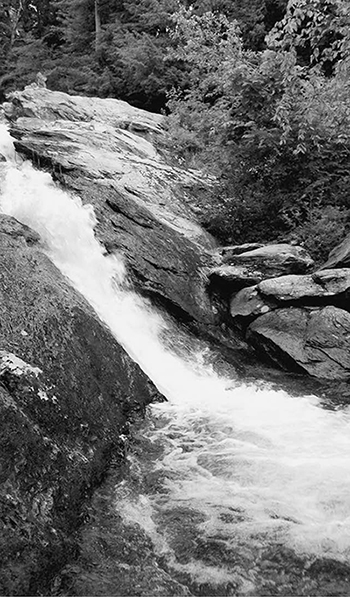
Upper Tubs on Wash Tub Brook. (Photograph 2014)
The cascades are found in two separate sections. In the upper section, a long chute leads into a narrow, deep gorge where a series of small cascades can be seen as you look down from the top of the ravine. The lower section consists of a large cascade, some 35 feet high. At the top, the stream is momentarily divided into two channels, which flow into a 15-foot-long rectangular pool. From the pool, the stream, now consolidated, races down a 50-foot-long chute, dropping over 25 feet in the process and picking up speed so that it reaches the end of the flume greatly compressed and accelerated.
The name Tubs derives from the potholes in the bedrock along the brook that hikers have used as convenient bathing holes, or tubs, for cooling off on hot summer days.
HISTORY: At one time, another prominent cascade, called Weeping Rocks, could be found nearby along an old road called the Dugway. It was a favorite attraction until road construction obliterated it in 1960.
Another nearby attraction called the Tubs made it into an earlier version of the Vermont Atlas and Gazetteer, which described it as three large potholes in a stream which flows through crystalline marble and limestone. It is located farther downstream on posted land, and inaccessible.
DIRECTIONS: From Bennington (junction of VT 9 and US 7) drive south on US 7 for ~9.0 miles to Pownal. Turn right onto VT 346 and drive northwest for 3.6 miles.
From North Petersburg, New York (junction of NY 22 and NY 346), drive southeast on NY/VT 346 for 3.7 miles.
Approaching from either direction, turn east onto North Pownal Road and drive over 0.2 mile. Then turn left onto Skiparee Road and drive north for 1.3 miles. When you come to a Y in the road, veer right and proceed northeast for over 0.1 mile. Park in a pull-off on your right.
Walk back along the road for 75 feet and follow a path to your left that immediately turns into an old abandoned road. Follow the old road for less than 0.1 mile to where the first set of cascades can be seen to your left in a deep gorge.
Continue following the old road for another 0.05 mile. At a fork, go left, heading down toward the top of the main falls. From here, the path divides. One path takes you to the top of the falls; the other leads you on a modified bushwhack around and down to the base of the falls.
After exploring the main waterfall, ford the creek upstream from the top of the falls and follow a path upstream along the top of the east bank for several hundred feet. It will take you to an overlook of a pretty, 15-foot-high cascade that is not visible from the old road on the hike in.
Location: Paper Mill Village (Bennington County)
DeLorme Vermont Atlas and Gazetteer: p. 20, F6
GPS: 4254.744N 7314.032W
Views: Head-on
Aesthetics: Fair
Characteristics: Small, historic, urban
Accessibility: To dam on first channel150-foot walk; cascades on second channelat roadside
Degree of Difficulty: Easy
DESCRIPTION: Both the dam-created falls and the natural cascades are found on the Walloomsac Rivera 17-mile-long river that rises near Woodford Hollow and flows into the Hoosic River west of North Hoosick. The part of the river farthest east is known locally as Roaring Branch.
At one time, a natural waterfall existed on the covered-bridge channel until a dam was built over it. No obvious trace of that falls remains today. Nevertheless, if you compare the height of the bedrock both above and below the dam, you will notice an appreciable drop in the level of the river.
Next pageFont size:
Interval:
Bookmark:
Similar books «Vermont Waterfalls»
Look at similar books to Vermont Waterfalls. We have selected literature similar in name and meaning in the hope of providing readers with more options to find new, interesting, not yet read works.
Discussion, reviews of the book Vermont Waterfalls and just readers' own opinions. Leave your comments, write what you think about the work, its meaning or the main characters. Specify what exactly you liked and what you didn't like, and why you think so.