About the Author
Eli Burakian is an outdoors enthusiast, writer, and photographer based in Vermont. He photographed a number of books in the Knack series, including Knack Hiking and Backpacking. His other books include Moosilauke: A Portrait of a Mountain and Best Easy Day Hikes Green Mountains. In addition to his writing and photography pursuits, he is the Dartmouth College Photographer in Hanover, NH. An avid long-distance backpacker, Eli makes it a priority to go on at least one big adventure each year. Visit him at BurakianPhotography.com.
ACKNOWLEDGMENTS
First and foremost, Id like to thank my wife, Julia, who has been so supportive throughout the process of putting this book together. She was pregnant for most of the time I was doing my fieldwork and dealing with our son at night while I was at the computer cranking away. She inspires me with her energy and love. Id also like to thank my son, Levon, who in his few short months of life has brought us many smiles. I cant wait to visit these waterfalls with him someday.
My parents have always supported me throughout my life, and their energy and joy of life is something I hope I can maintain as I age gracefully like they have. My grandmother, whom I lovingly call Bana, is someone else who has inspired me throughout my life. She got her bachelors and masters degrees well into her senior years and has shown me that nothing is ever beyond our reach.
Greg Parsons and Kate Watsons book New England Waterfalls and Dean Gosss website northeastwaterfalls.com helped provide so much information in the research for this book; I owe them a big thank you.
And finally, thank you Otis and Tigran, who, with their combined eight legs, are always enthusiastic hiking companions.
CONNECTICUT
Indian Well Falls
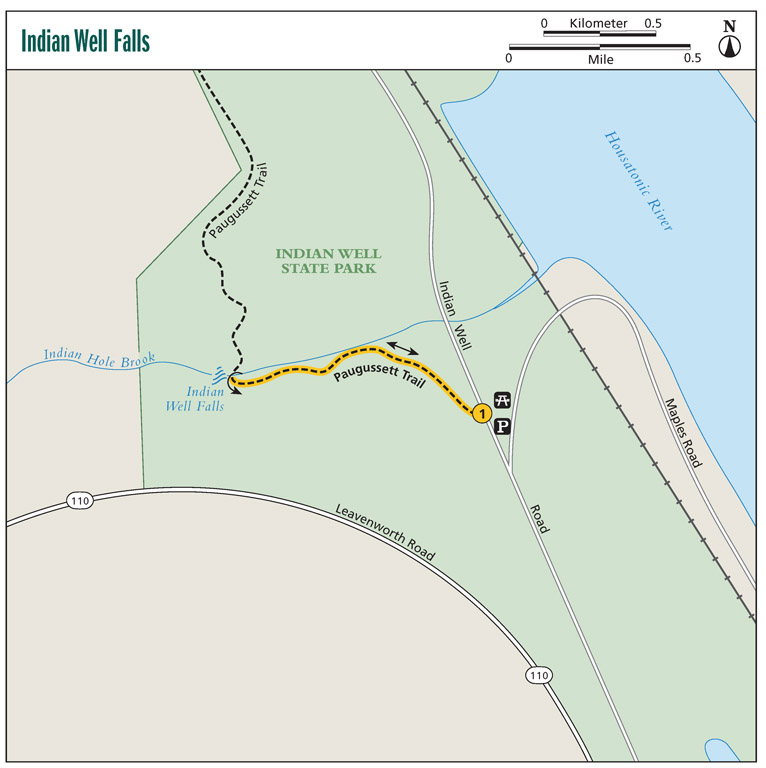
This short, flat hike leads to a 15-foot waterfall tucked into a small circular gorge. Indian Well State Park also has a nice beach along the Housatonic River, as well as a picnic area and boat launch. The trail to the falls is part of the 9.2-mile Paugussett Trail.
Start: Parking lot on Indian Well Road
Distance: 0.3 mile out and back
Hiking time: About 15 minutes
Approximate elevation gain: 25 feet
Difficulty: Easy
Beauty: Good
County: Fairfield
Land status: Indian Well State Park
DeLorme map: Page 24, G-2
Other map: Indian Well State Park Map, www.ct.gov/deep/lib/deep/stateparks/maps/indianwell.pdf
Trail contact: Connecticut State Parks and Forests (part of the Department of Energy and Environmental Protection); (860) 424-3000; www.ct.gov/deep/indianwell
Special considerations: Parking is free for the falls but not for the beach.
Finding the trailhead: (From CT 8) Take exit 14 in Shelton and follow CT 110 / Howe Avenue north for 2.2 miles. Turn right onto Indian Well Road, following signs for Indian Well State Park. Park in a lot on the right in 0.4 mile.
(From I-84 near Danbury) Take exit 11 and follow signs for CT 34 East. Continue on CT 34 for 13 miles and turn right onto Bridge Street in Derby, which heads to Shelton. Across the river take CT 110 / Howe Avenue; follow this for 1.8 miles and turn right onto Indian Well Road, following signs for Indian Well State Park. Park in a lot on the right in 0.4 mile.
The trail begins across the street and follows the stream. GPS: N41 20.280' / W73 07.416'
The Hike
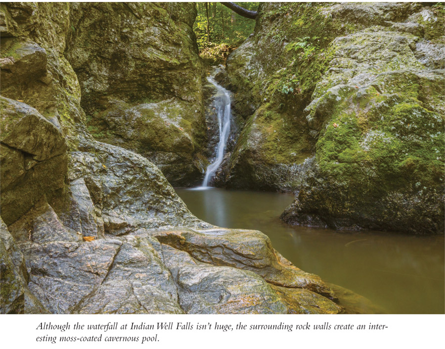
Although the waterfall here is a single 15-foot horsetail, the gorge that encompasses the waterfall is very interesting. The falls pour into a circular pool surrounded by tall vertical walls. The trail is part of the 9.2-mile Paugussett Trail, which crosses the brook here and climbs steeply before traversing all of Indian Well State Park. There are nice views of the Housatonic River from farther along the trail.
To get to the waterfall, cross the road from the parking area. The trail begins to the left of a bridge and follows along the edge of Indian Hole Brook, reaching the falls in 0.15 mile. Return to the parking area on the same trail.
Miles and Directions
| 0.0 | Start from the parking area. Cross the road and take the trail that starts next to the bridge and heads upstream. |
| 0.15 | Reach Indian Well Falls (N41 20.319' / W73 07.587'). Return the way you came. |
| 0.3 | Arrive back at the parking area. |
Spruce Brook Falls
This short hike follows a cool mossy stream through the Spruce Brook Ravine in a forest filled with towering trees, where a number of falls, the largest at 15 feet, tumble into pools of various shapes and sizes.
Start: Clearing at left fork at end of Cold Spring Road
Distance: 1.0 mile out and back
Hiking time: About 20 minutes
Approximate elevation gain: 200 feet
Difficulty: Easy
Beauty: Excellent
County: New Haven
Land status: Naugatuck State Forest
DeLorme map: Page 33, L-17 & L-18 (unmarked)
Other map: Naugatuck State Forest Map, ct.gov/deep/lib/deep/stateparks/maps/NaugatuckEastWestBlocksTrailMap.pdf
Trail contact: Connecticut State Parks and Forests (part of the Department of Energy and Environmental Protection); (860) 424-3000; www.ct.gov/deep/stateparks
Finding the trailhead: (From the north) Take exit 24 off CT 8, 8 miles south of Waterbury. Turn right onto North Main Street then take the first right onto Depot Street. After crossing a bridge, turn right onto Lopus Road and in 0.1 mile turn right onto Cold Spring Road, which becomes a rough dirt road. Travel for 1 mile; bear left at the fork and park in a clearing at the end of the road.
(From the south) Take exit 23 off CT 8, 8 miles north of Derby. Turn right onto CT 42 / South Main Street; follow this for 1 mile and turn left onto Depot Street. After crossing a bridge, turn right onto Lopus Road. In 0.1 mile turn right onto Cold Spring Road, which becomes a rough dirt road. Travel for 1 mile; bear left at the fork and park in a clearing at the end of the road. GPS: N41 27.318' / W73 03.801'
The Hike
The falls here are nice, but the cool ravine with its steep walls, giant boulders, and moss-covered walls makes this area worth a visit even when the water is low. Do note, however, that in late summer or times of extended dry periods, the falls all but disappear.
From the parking area, take the trail that heads down to the right. This will curve around to the left as it begins heading upstream in the ravine. At 0.25 mile, you will reach the largest waterfall, a 15 foot plunge. Travel for another quarter mile, passing by multiple cascades, some of which are split by one or more boulders. Return back to the parking on the same trail.


