THOMAS H. KEELS

Published by The History Press
Charleston, SC 29403
www.historypress.net
Copyright 2010 by Thomas H. Keels
All rights reserved
Images are from the authors collection unless otherwise noted.
First published 2010
Second printing 2010
Third printing 2011
e-book edition 2011
ISBN 978.1.61423.105.9
Keels, Thomas H.
Wicked Philadelphia : sin in the city of brotherly love / Thomas H. Keels. p. cm.
Includes bibliographical references.
print edition ISBN 978-1-59629-787-6
1. Philadelphia (Pa.)--History--Anecdotes. 2. Crime--Pennsylvania--Philadelphia--Anecdotes. 3. Scandals--Pennsylvania--Philadelphia--Anecdotes. 4. Philadelphia (Pa.)--Biography--Anecdotes. I. Title.
F158.36.K44 2009
974.811--dc22
2009050438
Notice: The information in this book is true and complete to the best of our knowledge. It is offered without guarantee on the part of the author or The History Press. The author and The History Press disclaim all liability in connection with the use of this book.
All rights reserved. No part of this book may be reproduced or transmitted in any form whatsoever without prior written permission from the publisher except in the case of brief quotations embodied in critical articles and reviews.
CONTENTS
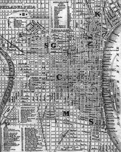
Philadelphia and environs, circa 1840. The city is indicated with a C. Below it are Southwark (S) and Moyamensing (M); above it are Kensington (K), Northern Liberties (NL) and Spring Garden (SG).
A NOTE ON GEOGRAPHY
Between 1682 and 1854, the city of Philadelphia consisted of a twelve-hundred-acre rectangle bordered by the Delaware River on the east, Vine Street on the north, the Schuylkill River on the west and Cedar (today South) Street on the south. The rectangle was divided into four quadrants by two major boulevards: Broad Street, running north and south, and High (later Market) Street, running east and west. These two avenues intersected at Centre Square, later known as Penn Square. Since 1871, Penn Square has been the location of City Hall.
The citys major eastwest streets were named after native plants, although several were later renamed. From north to south, they were: Vine, Sassafras (today Race), Cherry, Mulberry (today Arch), Filbert, High (Market), Chestnut, Walnut, Locust, Spruce, Pine, Lombard and Cedar (South).
The northsouth streets were numbered, except for the oldest ones along each river (Water and Front Streets on the Delaware, Ashton and Beach on the Schuylkill). Originally, streets east of Broad ran from Delaware Second to Delaware Thirteenth as you moved west. Streets west of Broad ran from Schuylkill First to Schuylkill Eighth as you moved east. In 1853, the City Councils finally realized how confusing this was and renumbered the streets consecutively from Second Street near the Delaware to Twenty-fourth Street near the Schuylkill. Just to keep things a little confusing, Broad Street continued to take the place of Fourteenth Street.
The fast-growing city was soon ringed by other boomtowns. Below South Street, rough-and-tumble Southwark ran along the Delaware, while semirural Moyamensing sprawled to the west. Above Vine Street, Northern Liberties stood to the east and Spring Garden to the west. In 1800, when Philadelphia was the largest city in the United States, Northern Liberties was the sixth largest and Southwark the seventh largest.
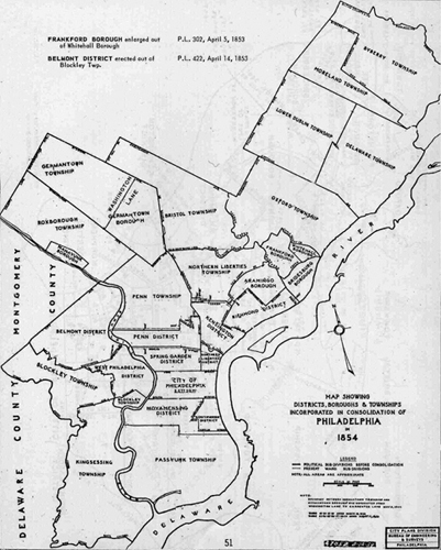
The patchwork of boroughs, townships and districts that constituted Philadelphia County prior to its consolidation with the city of Philadelphia in 1854.
The rest of Philadelphia County was a patchwork of villages, districts, boroughs and townships, many predating the city itself. Passyunk Township occupied the southern tip of the city. Across the Schuylkill, West Philadelphia was ringed by Belmont District, Blockley Township and Kingsessing Township.
The Wissahickon Creek ran through the northwestern arm of the county, dividing rural Roxborough and the mill town of Manayunk in the south from the venerable settlement of Germantown to the north. During the nineteenth century, Germantowns northwestern end became known as Mount Airy and Chestnut Hill, home to the estates of the wealthy.
Along the Delaware River north of the city stood the ancient neighborhoods of Kensington, Richmond and Bridesburg, with Frankford and Oxford farther inland. The far northeastwhich remained mostly rural until after World War IIconsisted of Delaware, Lower Dublin, Moreland and Byberry Townships.
In 1854, the Act of Consolidation merged the city of Philadelphia with the surrounding county, creating its current boundaries and making it the largest American metropolis in terms of physical size at the time.
ACKNOWLEDGEMENTS
Like Macbeth, Wicked Philadelphia was born with the help of three midwives with a taste for the macabre: Diana Cammarota, the original editor and publisher of the Rittenhouse Sq. Revue; Dan Herman, her successor at the Revue; and Jim Cotter, host and producer of Creatively Speaking, the weekly arts and culture program on Temple Universitys WRTI-FM.
Most of the chapters in Wicked Philadelphia originated as articles in the Revue or radio features on Creatively Speaking. I owe Diana, Dan and Jim my deepest thanks for handing me a shovel and encouraging me to dig deep into the dark crevasses of my adopted city. This book would not have been possible without their support, creativity and friendship.
Hannah Cassilly of The History Press suggested the theme of Wicked Philadelphia and has worked with me closely to develop and shape this book. I am deeply grateful for her assistance.
I must also thank the following people for their help: Michael Angelo, archivist at Thomas Jefferson University; Adam Bell of the Charlotte Observer; Michael Brooks; Emily Cooperman; Brenda Galloway-Wright and the staff of the Urban Archives at Temple University; Mary Lou Hughes and the staff of the Free Library of Springfield Township (Montgomery County); Cornelia S. King, chief of reference at the Library Company of Philadelphia; Nancy R. Miller of the University of Pennsylvania Archives; James Mundy, archivist of the Union League of Philadelphia; David Rowland and Betty Smith of the Old York Road Historical Society; John Schimpf; Phillip Seitz, curator of History and Fermentation at Cliveden of the National Trust; Brian Shovers, library manager of the Montana Research Center; Robert Morris Skaler; Nancy V. Webster; and Marie Brown Wilson of the Explore PA History Project.
As always, my deepest thanks go to my partner and friend, Lawrence M. Arrigale, for his help as photographer, editor and tech support; his unflagging enthusiasm and encouragement; and his infinite kindness, patience and love. Without him, I might easily have ended up as a chapter in this book!
INTRODUCTION
O that thou mayest be kept from the evil that would overwhelm thee, that faithful to the God of thy mercies in the life of righteousness, thou mayest be preserved to the end.
Next page

