

Published by The History Press
Charleston, SC
www.historypress.net
Copyright 2017 by Douglas L. Heath and Alison C. Simcox
All rights reserved
First published 2017
e-book edition 2017
ISBN 978.1.43966.170.3
Library of Congress Control Number: 2017934948
print edition ISBN 978.1.46713.667.9
Notice: The information in this book is true and complete to the best of our knowledge. It is offered without guarantee on the part of the authors or The History Press. The authors and The History Press disclaim all liability in connection with the use of this book.
All rights reserved. No part of this book may be reproduced or transmitted in any form whatsoever without prior written permission from the publisher except in the case of brief quotations embodied in critical articles and reviews.
To our mothers, Dorothy Thayer Heath and Margaret E. Simcox, whose lives inspire us and whose love sustains us.
Contents
Acknowledgements
First, we acknowledge the contributions of women who helped their husbands and sons succeed in their mill businesses and endured the hardships of domestic life in past centuries. We recognize the children who worked and suffered in mills and factories before the passage of child labor laws. We also acknowledge the African Americans who worked for the mill families, many as slaves, and were denied the dignity of full citizenship. All of these people are part of our shared history.
We thank many people for helping make this book possible. First, Ryan Hayward of the Preservation Collaborative generously shared his extensive knowledge of Haywardville as well as photographs and historical documents. We thank Gary Walter of the Colchester Historical Society for granting us access to the societys collection of Hayward family photographs. Susan Lisk of the Porter-Phelps-Huntington Museum in Hadley, Massachusetts, allowed us to include portraits of William and Mary Barrett in our book. Donald Delay and Priscilla Scroggins, greatgrandchildren of Susan (Dean) Richardson, kindly provided images of her brass school bell and gold pocket watch.
The following groups lent us materials from their collections: Stoneham, Melrose and Malden Public Libraries; Amherst College Library; Baker Library at Harvard University; Medford Historical Society & Museum; Stoneham Historical Society; New England Historical Genealogical Society; American Antiquarian Society; Massachusetts Archives; and the South Middlesex County Registry of Deeds.
As always, we thank our wonderful sons, Ian and Alec, who remind us that history only stays alive if passed on to younger generations. Last, but not least, special thanks to Amanda Irle and Ryan Finn, our editors at The History Press, who were supportive throughout.
Introduction
At the end of the Wisconsin glacial period, about fourteen thousand years ago, the landscape north of present-day Boston was sculpted by glaciers, pocked with kettle ponds and littered with boulders. Gushing streams, carrying meltwater from wasting glaciers to the north, rushed downhill and discharged into the sea. By nine thousand years ago, hardwood treessuch as beech, oak and maplehad begun to appear, and wetlands provided rich habitats for plants, birds, deer and other animals. By this time, the first people, known as Paleo-Indians, had moved into the area. They hunted caribou and other tundra animals using spears with fluted points, which have been found on hilltops, the sides of valleys and the shores of glacial lakes throughout New England.
Sites dating back 9,500 years exist on the Arlington Plain and lower Charles River, along the shores of the Mystic Lakes and along the Saugus River. Native people caught fish from the Mystic River and Alewife Brook and shellfish from the nearby coast and traveled inland to camp during the winter. By about three thousand years ago, their descendants had developed additional tools for hunting, including fish weirs, and were making pottery and growing squash and gourds. They had also begun settling in campsites, with trading becoming more important.
At the time of European contact in the seventeenth century, native people in northeastern Massachusetts were the Massachusets (or the Pawtuckets, according to some scholars). Their chief sachem was Nanepashemet, and his domain stretched from the Charles River north to present-day Salem, Lynn and Marblehead and extended westerly to Concord. In 1619, Nanepashemet was killed by Mikmaq raiders from the north (also called Tarrantines), and his wife, Squaw Sachem, took over his domain. One of the areas where the Massachusets lived, an area that had been inhabited for thousands of years, was on the northern and eastern shores of a glacial kettle pond, now called Spot Pond. They built wigwams with saplings arranged in a circle and bent to form an arch at the top, which they covered with bullrush leaves. Daily life focused on growing crops such as squash, maize and beans; hunting and fishing; and making tools. But contact with Europeans altered their culture profoundly. Diseases decimated the native population. By the mid-seventeenth century, most remaining native people had left the coastal lowlands under pressure from the growing British colony and moved to nearby upland areas.
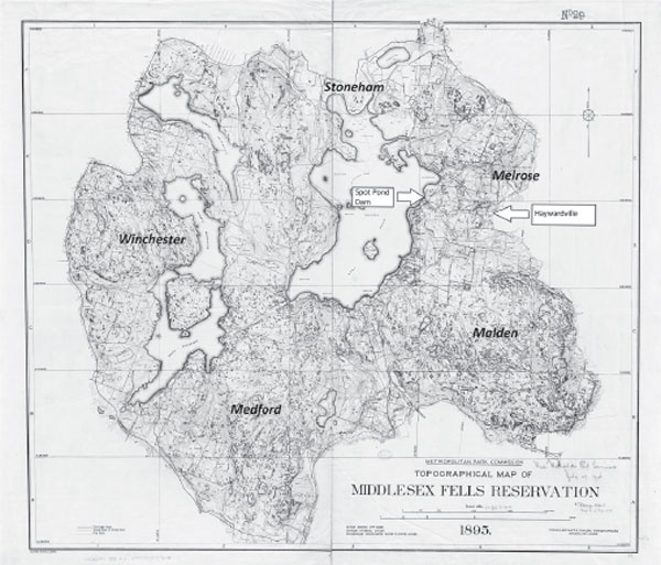
French, Bryant & Taylor, topographers of Brookline, Massachusetts, published this map of Middlesex Fells Reservation in 1895 for the Metropolitan Park Commission. The reservation lies five miles north of Boston in Stoneham, Medford, Melrose, Malden and Winchester. Boston Public Library.
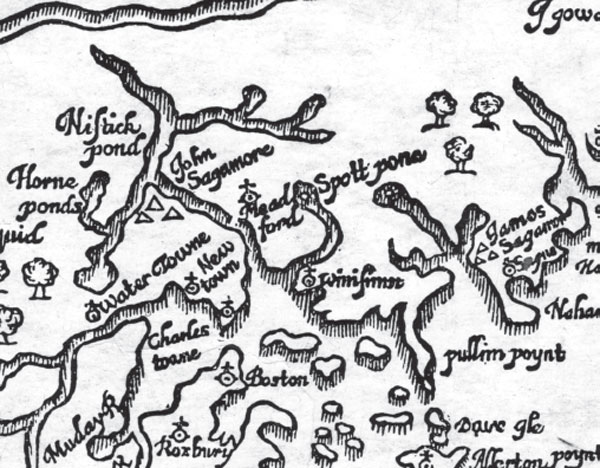
Detail of William Woods map of New England, published in London in 1634 in the New England Prospect. This is the first map made showing Spot Pond and Spot Pond Brook (flowing southward). Boston Public Library.

Circa 1630 portrait of John Winthrop made by an unknown artist, probably in England. While governor of the Massachusetts Bay Colony, Winthrop explored the Spot Pond area in 1632. He married Martha (Rainborowe), the widow of Thomas Coytmore, who built the first mill on Spot Pond Brook. American Antiquarian Society.
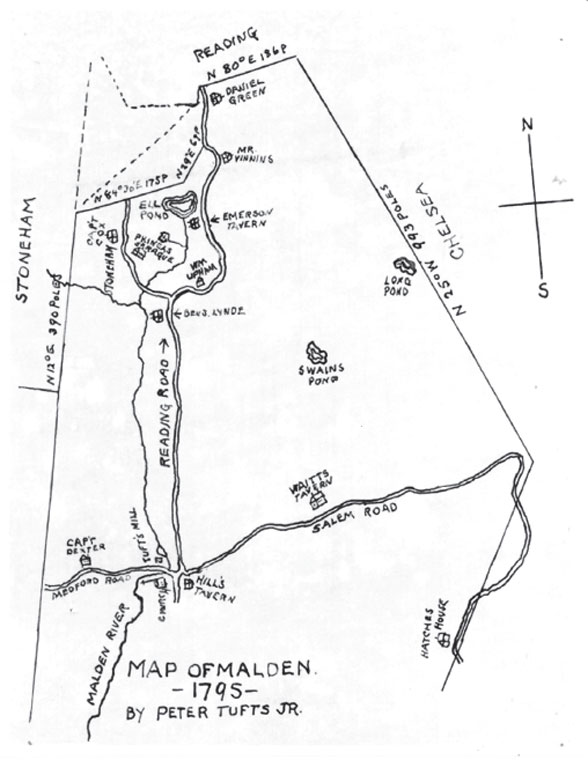
Peter Tufts Jr. drew this map of Malden in 1795. It shows Tuftss mill (formerly Coytmores mill), Hills Tavern and Spot Pond Brook flowing eastward from Stoneham and southward parallel to Reading Road. Malden Public Library.
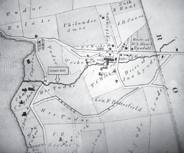
This enlargement of G.M. Hopkinss 1874 map of Stoneham shows property boundaries and mills along Spot Pond Brook in Stoneham. Stoneham Public Library
Next page
