Amre Youssef - Floods of Northern New Jersey
Here you can read online Amre Youssef - Floods of Northern New Jersey full text of the book (entire story) in english for free. Download pdf and epub, get meaning, cover and reviews about this ebook. year: 2014, publisher: Arcadia Publishing, genre: Non-fiction. Description of the work, (preface) as well as reviews are available. Best literature library LitArk.com created for fans of good reading and offers a wide selection of genres:
Romance novel
Science fiction
Adventure
Detective
Science
History
Home and family
Prose
Art
Politics
Computer
Non-fiction
Religion
Business
Children
Humor
Choose a favorite category and find really read worthwhile books. Enjoy immersion in the world of imagination, feel the emotions of the characters or learn something new for yourself, make an fascinating discovery.

- Book:Floods of Northern New Jersey
- Author:
- Publisher:Arcadia Publishing
- Genre:
- Year:2014
- Rating:5 / 5
- Favourites:Add to favourites
- Your mark:
Floods of Northern New Jersey: summary, description and annotation
We offer to read an annotation, description, summary or preface (depends on what the author of the book "Floods of Northern New Jersey" wrote himself). If you haven't found the necessary information about the book — write in the comments, we will try to find it.
Situated between winding rivers and prone to turbulent storms, northern New Jersey has had an extensive and tumultuous history of flooding. The most severe flood occurred in 1903 when three days of nonstop rain, averaging 12 inches per day, melted more than 23 inches of snow and iceinundating the cities of Passaic and Wallington and splitting Paterson in two. Since 1945, more than 60 documented storms have wreaked havoc and shaken the region. In 2011, the second-worst storm in North Jerseys history, Hurricane Irene, struck with more than 11 inches of rain, displacing 6,000 residents in Paterson alone and hitting Bergen and Passaic Counties with a vengeance. Only one year later, Superstorm Sandy rolled into North Jersey, flooding Moonachie and Little Ferry with surges up to five feet. Floods of Northern New Jersey showcases the rich documentation of flooding through a unique and significant photographic collection.
Amre Youssef: author's other books
Who wrote Floods of Northern New Jersey? Find out the surname, the name of the author of the book and a list of all author's works by series.


Floods of Northern New Jersey — read online for free the complete book (whole text) full work
Below is the text of the book, divided by pages. System saving the place of the last page read, allows you to conveniently read the book "Floods of Northern New Jersey" online for free, without having to search again every time where you left off. Put a bookmark, and you can go to the page where you finished reading at any time.
Font size:
Interval:
Bookmark:
IMAGES
of America
FLOODS OF
NORTHERN NEW JERSEY
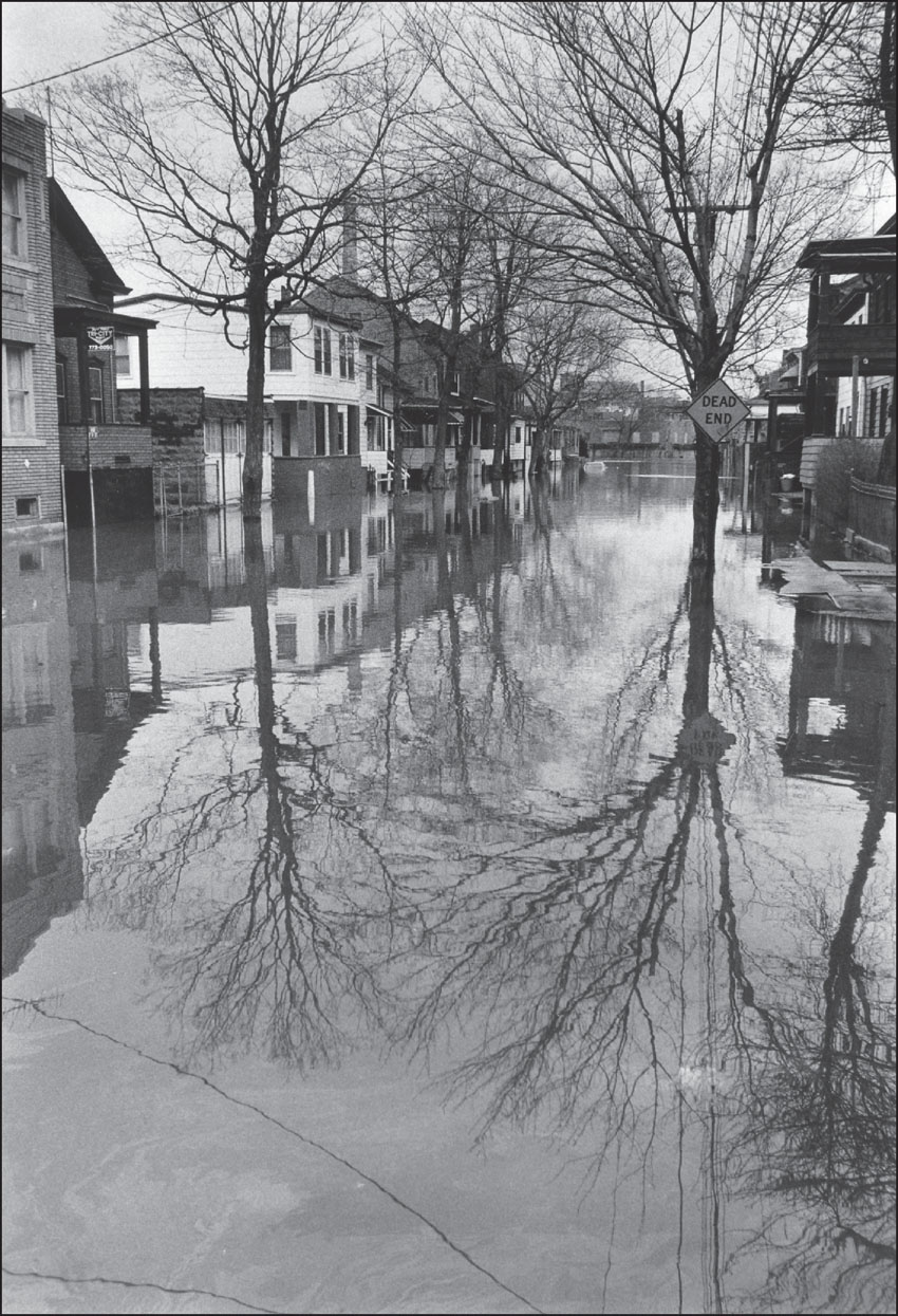
The Passaic River flooded East Holsman Street in Paterson for two days after heavy rains fell on February 1 and 2 in 1973. Usually, residents had to walk to the end of the block to see the river, but not on this day. This view looks down East Holsman Street toward the Passaic River. (Photograph by Dan Oliver; courtesy of the Record archives.)
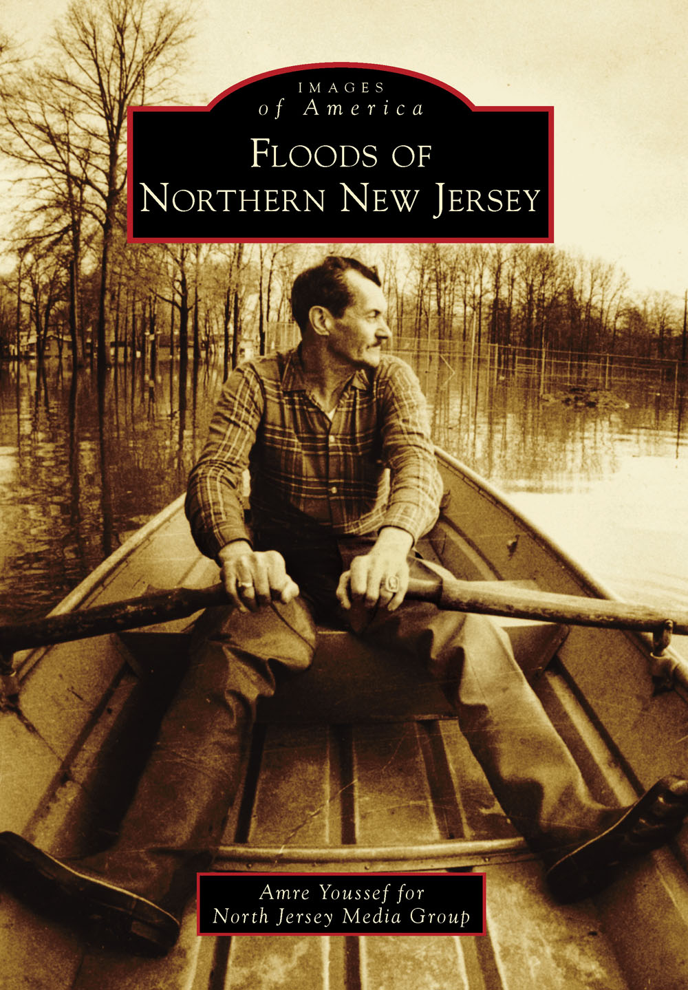
ON THE COVER: Fayette Avenue in Wayne flooded in 1980. Emil Begyn woke up early in the morning to survey the damage and took a tour with Record photographer Peter Karas. (Photograph by Peter Karas; courtesy of the Record archives.)
IMAGES
of America
FLOODS OF
NORTHERN NEW JERSEY
Amre Youssef for
North Jersey Media Group

Copyright 2014 by North Jersey Media Group
ISBN 978-1-4671-2087-6
Ebook ISBN 9781439644706
Published by Arcadia Publishing
Charleston, South Carolina
Library of Congress Control Number: 2013943502
For all general information, please contact Arcadia Publishing:
Telephone 843-853-2070
Fax 843-853-0044
E-mail
For customer service and orders:
Toll-Free 1-888-313-2665
Visit us on the Internet at www.arcadiapublishing.com
This book is dedicated to the victims of North Jersey who have been affected physically, financially, and emotionally by the ongoing flooding in our region and to the heroes who have risked their lives to save their fellow citizens.
CONTENTS
ACKNOWLEDGMENTS
Thanks to all the people who provided their valuable skills to complete this book. Special thanks go to Zhanna Gitina for her tireless efforts in scanning and reproducing the historical images that appear in this book and to Glenn Garvie for editing.
Thanks also go to Donna Blair, Joan Callahan, Doug Clancy, Giacomo DeStafano, Glenn Garvie, Bill George, Vince Marchese, R.P. McGrantham, Nancy McMullen, Peggy Norris, and E.A Smyck.
INTRODUCTION
The Gulf Coast is hammered by hurricanes, California is rocked by earthquakes, and Oklahoma is ripped apart by tornadoes. In North Jersey, we have flooding.
A natural disaster that has been exacerbated by development, flooding has become so chronic that some residents have come to expect deluged basements, evacuations, and visits from insurance adjusters every spring.
In the last five years alone, the region has endured three of the costliest floods on record, amassing an estimated $2 billion in damages. Eleven floods since 1968 have prompted federal disaster declarations, including ones in 2007 and 2010. Heavy rains in 2011 wrought more destruction, leaving some neighborhoods under chest-high water.
The problem is nothing new. The first recorded flood happened a decade before the Declaration of Independence was signed. The worst came in 1903, when the Passaic River at Little Falls crested at 17.5 feet. Even as the power of the Great Falls spurred the American Industrial Revolution, the factories and homes that sprang up along the river were often swamped by floods.
But the postWorld War II housing boom in towns like Wayne, Little Falls, and Pompton Lakes, coupled with the construction of Willowbrook Mall and a vast highway system, have made the flooding worse. The winter thaw and the heavy rains of March and April have few places to go with so much asphalt and concrete covering what used to be a prehistoric lake.
In Bergen County, a deluge often forces emergency officials to bring out boats to evacuate residents of Hackensack, and neighborhoods in Saddle Brook, Lodi, and Carlstadt are often under siege by floodwaters. Tropical Storm Floyd in 1999 was especially bad, as every stream, brook, and river seemed to overflow, swamping dozens of towns in just a few short hours. A dam in Rockland County broke, sending a surge of water into Hillsdale.
Federal and state officials have spent decades searching for a solution. A special commission created by Gov. Chris Christie recommended several ways to minimize flooding in the Passaic River Basin, from removing dams to elevating homes. Some houses in floodplains are being bought out. But solutions can have unintended consequences: floodgates that helped stop flooding in Oakland may be responsible for increased flooding in Pompton Lakes.
The governors commission made this sobering conclusion: There is no silver bullet that will solve the flooding... none of its recommendations can change the reality of the Passaic River Basin: Floodplains will continue to flood in this basin.
One
A HISTORY OF FLOODING
IN NORTH JERSEY
The flood of 1903 hit North Jersey between October 9 and 13 and was termed the flood of record. It exceeded all previously recorded floods since Colonial times, including the previous flood of 1902. The flood destroyed bridges, dams, railroads, residences, and industries. It was a vicious tropical storm that caused the Passaic, Ramapo, and Pompton Rivers to swell and flood its nearby towns. On October 10, the Passaic River crested at Little Falls, measuring 17.5 feet. This is three feet more than the August 2012 Hurricane Irene, the second worst flooding disaster in North Jerseys history.
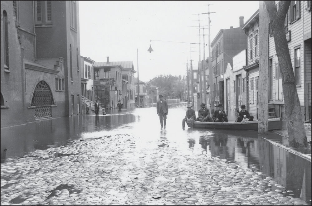
On the first day of the storm of 1903, Paterson received 11.4 inches of rain. Two days later, that number climbed to 15 inches. It took its toll on the citys thriving silk industry, injured hundreds, and left three people dead. A couple of minutes after its encounter with Paterson, the storm turned to Bergen County, wreaking more havoc across the county. (Photograph by Leonard Doremus; courtesy of the Paterson Museum.)
Near the Little and Great Falls, dams and highway bridges succumbed to the powerful rage of the flood. The West Street Bridge, the first bridge right below the falls, split and was carried away by strong currents, as seen in this 1903 image taken in Paterson. (Courtesy of Gene Marchese.)
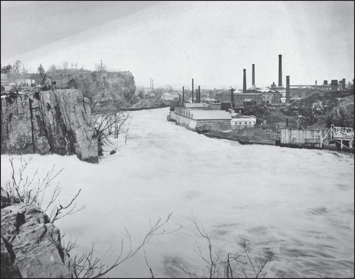
This is a 1903 aerial view of Patersons scenic Valley of the Rocks, situated near the Great Falls. The Valley of the Rocks overlooked many of the great mill buildings that fueled the prospering city. (Courtesy of Gene Marchese.)
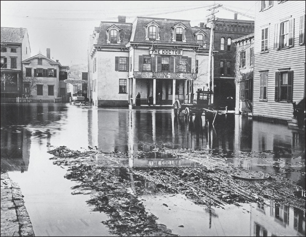
This image was also captured in Paterson in 1903. This scene at River Street near Arch Street is a common place for flooding that has endured throughout the years. The Arch Street Bridge (not shown), built only one year earlier at a cost of $34,000, collapsed during the flood. (Courtesy of Gene Marchese.)
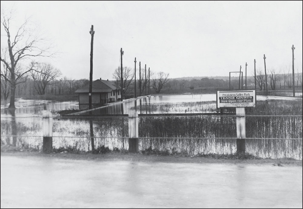
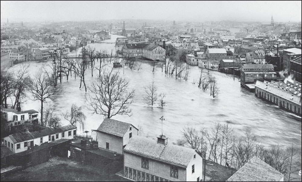
Rising waters of the Passaic River brought many homes along the banks perilously close to inundation. The county road department reported on November 10, 1932, that there were a number of road washouts, particularly in the back hill country. Shown above is the effect of the storm on the Preakness Valley Parks tennis courts near Valley Road in Wayne. Note that permits and licenses were issued on 45 Church Street in Paterson. Flooding also took place near the Dey Mansion. Constructed in 1750, the mansion once served as the headquarters for Gen. George Washington. It is known today as the Jewel of the Passaic County Parks Department. The golf course below is located in the borough of Totowa and is one of the first 100 golf clubs to be established in the United States. (Both, courtesy of the
Next pageFont size:
Interval:
Bookmark:
Similar books «Floods of Northern New Jersey»
Look at similar books to Floods of Northern New Jersey. We have selected literature similar in name and meaning in the hope of providing readers with more options to find new, interesting, not yet read works.
Discussion, reviews of the book Floods of Northern New Jersey and just readers' own opinions. Leave your comments, write what you think about the work, its meaning or the main characters. Specify what exactly you liked and what you didn't like, and why you think so.