Zurick David - Illustrated Atlas of the Himalaya
Here you can read online Zurick David - Illustrated Atlas of the Himalaya full text of the book (entire story) in english for free. Download pdf and epub, get meaning, cover and reviews about this ebook. publisher: University Press of Kentucky, genre: Politics. Description of the work, (preface) as well as reviews are available. Best literature library LitArk.com created for fans of good reading and offers a wide selection of genres:
Romance novel
Science fiction
Adventure
Detective
Science
History
Home and family
Prose
Art
Politics
Computer
Non-fiction
Religion
Business
Children
Humor
Choose a favorite category and find really read worthwhile books. Enjoy immersion in the world of imagination, feel the emotions of the characters or learn something new for yourself, make an fascinating discovery.

- Book:Illustrated Atlas of the Himalaya
- Author:
- Publisher:University Press of Kentucky
- Genre:
- Rating:3 / 5
- Favourites:Add to favourites
- Your mark:
Illustrated Atlas of the Himalaya: summary, description and annotation
We offer to read an annotation, description, summary or preface (depends on what the author of the book "Illustrated Atlas of the Himalaya" wrote himself). If you haven't found the necessary information about the book — write in the comments, we will try to find it.
Zurick David: author's other books
Who wrote Illustrated Atlas of the Himalaya? Find out the surname, the name of the author of the book and a list of all author's works by series.


Illustrated Atlas of the Himalaya — read online for free the complete book (whole text) full work
Below is the text of the book, divided by pages. System saving the place of the last page read, allows you to conveniently read the book "Illustrated Atlas of the Himalaya" online for free, without having to search again every time where you left off. Put a bookmark, and you can go to the page where you finished reading at any time.
Font size:
Interval:
Bookmark:
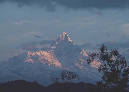
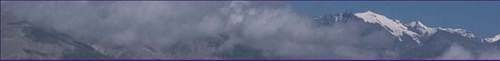
Machupuchhare Peak, located in central Nepal north of Pokhara Valley, is one of the few Himalayan summits still banned for climbing.
DAVID ZURICK & JULSUN PACHECO
With Basanta Shrestha & Birendra Bajracharya
University Press of Kentucky Lexington
Copyright 2006 by The University Press of Kentucky
Scholarly publisher for the Commonwealth,
serving Bellarmine University, Berea College, Centre
College of Kentucky, Eastern Kentucky University,
The Filson Historical Society, Georgetown College,
Kentucky Historical Society, Kentucky State University,
Morehead State University, Murray State University,
Northern Kentucky University, Transylvania University,
University of Kentucky, University of Louisville,
and Western Kentucky University.
All rights reserved.
Editorial and Sales Offices: The University Press of Kentucky
663 South Limestone Street, Lexington, Kentucky 40508-4008
www.kentuckypress.com
10 09 08 07 06 5 4 3 2 1
Maps copyright 2006 Julsun Pacheco
Photographs copyright 2006 David Zurick
Cataloging-in-Publication Data
is available from the Library of Congress.
The financial support of the following contributors
is gratefully acknowledged:

American Alpine Club, Colorado
American Geographical Society, New York
Banff Centre, Alberta, Canada
Eastern Kentucky University, Richmond
National Science Foundation, Washington, D.C.
 | This book is printed on acid-free recycled paper meeting the requirements of the American National Standard for Permanence in Paper for Printed Library Materials. |
Design and typesetting by Julie Allred, BW&A Books, Inc.
Printed in China through Asia Pacific Offset.
 | Member of the Association of American University Presses |
Maps
Tables and Charts
REFERENCE GRID
Acknowledgements
T his atlas is the culmination of many years of fieldwork in the Himalaya and cartographic work in Kentucky. In the former case, the mountains were traversed on foot, on horseback, by jeep, and by bus. In the latter case, the maps were rendered digitally in a computerized geographic information system. On both counts, the authors acknowledge and appreciate the assistance of numerous individuals and agencies.
Data compilation in the Himalaya for purposes of the atlas was facilitated by the International Centre for Integrated Mountain Development (ICIMOD). The current volume springs from an earlier document prepared with the assistance of ICIMOD staff members Basanta Shrestha and Birendra Bajracharya, utilizing some of ICIMOD's extensive digital data for the Himalaya. We are indebted to ICIMOD both for providing technical assistance and for producing that prior version of the atlas. Thanks also go to Dr. Harka Gurung, a world authority on the Himalaya, for reviewing early versions of the atlas and making significant editorial contributions. For field assistance in the Himalaya, the authors thank the following persons: Ibrahim Chapri (Kashmir); Tsering Phuntsok (Ladakh); Parvez Bhat (Ladakh and Zanzkar); Dorje Rinchen (Zanzkar); Sub-Inspector Singh (Lahaul and Spiti); Dilli Raj Joshi (Garhwal); Birendra Bajracharya, Prakash Pathak, Chris Monson, Mani Lama, Suresh Khadkha, Basanta Shrestha, and Rajendra Shrestha (Nepal); and Chencho Tshering, Karma Dorji, and Dawa Zangpo (Bhutan). A number of governmental and nongovernmental agencies assisted in the completion of fieldwork and the compilation of data, including the following: King Mahendra Trust for Nature, World Wildlife Fund-Nepal, Friends of Chipko, Ministry of Population and Environment-Nepal, Ministry of Tourism and Civil Aviation-Nepal, Wadia Institute of Geology, G. B. Pant Institute of Himalayan Environment and Development, Bhutan Trust Fund for Nature, Tribhuvan University, Map Point, Planning Commission-Nepal, Royal Government of Bhutan, and Department of National Parks and Wildlife Conservation-Nepal.
Financial support for Himalayan field studies over the years and for production of the atlas was provided by generous grants from the National Science Foundation, the American Geographical Society, American Alpine Club, Banff Centre, and Eastern Kentucky University. Eastern Kentucky University also provided excellent institutional support, including office space, leaves of absence, and a sabbatical research award for David Zurick. In support of his cartography, Julsun Pacheco thanks Gyula Pauer, Ev Wingert, and especially Richard Ulack, to whom the maps in the atlas are dedicated.
Special thanks go to Pradyumna Karan for his mentorship and unflagging support.
Julsun Pacheco is grateful to his wife, Cindy, and daughter, Natalie, for putting up with his disappearances into the digital cave in his house, and to his parents in the Philippines, who thought that he only knew how to build computers and were especially proud to learn that he could do something useful like make maps. David Zurick thanks his wife, Jennifer, for patiently enduring his absences while he was away in the mountains and, especially, for accompanying him on some of his fieldwork journeys.
Finally, we wish to thank Steve Wrinn, director of the University Press of Kentucky, for his enthusiastic embrace of this project, and all the Press staff who have helped turn our manuscript into this book.
Introduction
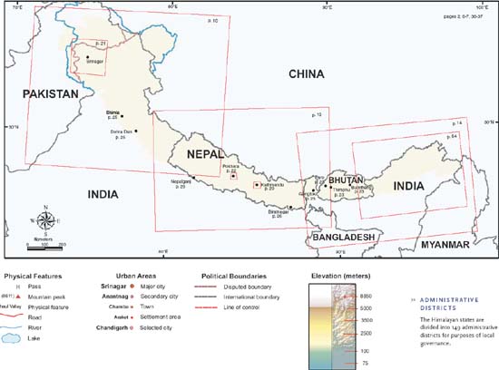
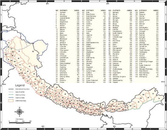
T he political geography of the Himalaya is contested in many places, with China asserting its claim over territory occupied by India and Bhutan, and India asserting its claim over territory occupied by Pakistan and vice versa. The boundary lines that appear on the maps in this atlas represent the most widely accepted designations of country borders; in some cases, again by convention, they appear as something other than a recognized boundary line (for example, the disputed boundary between Pakistan and India in Kashmir is depicted as a line of control). Such disagreements about boundary placements suggest the somewhat fluid nature of Himalayan geopolitics, which historically includes diverse relations among the neighboring mountain countries. The administrative divisions of territory within the individual Himalayan countries are also subject to change, most notably with the emergence of Uttaranchal in 2000 as a new mountain state of India, but also with countless smaller efforts to redraw district and settlement boundaries all across the mountains.
Font size:
Interval:
Bookmark:
Similar books «Illustrated Atlas of the Himalaya»
Look at similar books to Illustrated Atlas of the Himalaya. We have selected literature similar in name and meaning in the hope of providing readers with more options to find new, interesting, not yet read works.
Discussion, reviews of the book Illustrated Atlas of the Himalaya and just readers' own opinions. Leave your comments, write what you think about the work, its meaning or the main characters. Specify what exactly you liked and what you didn't like, and why you think so.