Peter Chasseaud - Mapping the First World War: The Great War through maps from 1914-1918
Here you can read online Peter Chasseaud - Mapping the First World War: The Great War through maps from 1914-1918 full text of the book (entire story) in english for free. Download pdf and epub, get meaning, cover and reviews about this ebook. year: 2013, publisher: HarperCollins UK, genre: Romance novel. Description of the work, (preface) as well as reviews are available. Best literature library LitArk.com created for fans of good reading and offers a wide selection of genres:
Romance novel
Science fiction
Adventure
Detective
Science
History
Home and family
Prose
Art
Politics
Computer
Non-fiction
Religion
Business
Children
Humor
Choose a favorite category and find really read worthwhile books. Enjoy immersion in the world of imagination, feel the emotions of the characters or learn something new for yourself, make an fascinating discovery.

- Book:Mapping the First World War: The Great War through maps from 1914-1918
- Author:
- Publisher:HarperCollins UK
- Genre:
- Year:2013
- Rating:4 / 5
- Favourites:Add to favourites
- Your mark:
Mapping the First World War: The Great War through maps from 1914-1918: summary, description and annotation
We offer to read an annotation, description, summary or preface (depends on what the author of the book "Mapping the First World War: The Great War through maps from 1914-1918" wrote himself). If you haven't found the necessary information about the book — write in the comments, we will try to find it.
Peter Chasseaud: author's other books
Who wrote Mapping the First World War: The Great War through maps from 1914-1918? Find out the surname, the name of the author of the book and a list of all author's works by series.


Mapping the First World War: The Great War through maps from 1914-1918 — read online for free the complete book (whole text) full work
Below is the text of the book, divided by pages. System saving the place of the last page read, allows you to conveniently read the book "Mapping the First World War: The Great War through maps from 1914-1918" online for free, without having to search again every time where you left off. Put a bookmark, and you can go to the page where you finished reading at any time.
Font size:
Interval:
Bookmark:
The Imperial War Museum, or National War Museum, as it was originally named, began to acquire maps and charts as soon as it was founded on 5 March 1917 to record the events still taking place during the Great War. The intention was to collect and display material as a record of civilian and military experiences during that war, and to commemorate the sacrifices of all sections of society.
Maps and charts were acquired by direct contact with the appropriate military and civil departments of government, and also by private donation, both during and after the war. In addition, maps produced and used by the Allies, and also captured maps and other enemy maps, found their way into the archive.
Many of the maps and charts had been used in military, naval and air headquarters in London and in the various active theatres of war. Their condition naturally varies a great deal: some are stained with mud and blood, and scarred by shell-splinter or bullet. None such is shown here, but several bear evidence of their field use in the form of manuscript annotations for enemy positions, intelligence notes, tank routes, etc. One of the most tragic reminders of the human cost of the conflict is the body count map of the Ypres Salient by the Imperial War Graves Commission at the end of the war, which appears at the end of the book.
Contents
There is a compelling view of the Western world in the years immediately before the outbreak of war in 1914 that, rather than a sunlit Edwardian (and Georgian) earthly paradise of prosperity and stability, it was an increasingly hysterical vortex of accelerating tensions and violence. God was dead or dying; man was becoming superman. Neo-Darwinist philosophies of action and doctrines of the necessity of the violent cleansing action of war vied with those extolling the new technologies of motor cars, aeroplanes and speed. In philosophy, politics and the arts, Nietzsche and nihilism, anarchism and syndicalism, modernism, imagism, cubism, futurism and vorticism all aimed to shatter bourgeois complacency and proclaimed the need to destroy in order to build a new society. The Newtonian equilibrium was destroyed; Einstein had promulgated his special theory of relativity. Like Nijinskys dancers in Stravinskys Le Sacre du printemps ( The Rite of Spring ), the jerky motion of the cinematograph contributed to the sense of fracturing. Yeats, in the aftermath of the next few years, was to write: Things fall apart; the centre cannot hold; Mere anarchy is loosed upon the world... , and Eliot his elegy for civilization, The Waste Land .
The neurotic envy and militarism of Germanys Kaiser Wilhelm led to the naval race with Britain, while the scramble for Africa aggravated imperial rivalries and took them to the brink of war. In France, Georges Sorel was creating a violent, anti-democratic, proto-fascist movement, and Henri Bergson was promoting anti-rationalism. In Britain women were clamouring for the vote, the workers for higher wages, the Irish nationalists for home-rule and the Ulstermen for no-surrender. In 1914, as Sinn Fin, Irish Republican Brotherhood and other nationalists, and the Ulster Volunteers drilled and armed, British army officers at the Curragh barracks, outside Dublin, prepared to mutiny in support of Ulster. The prospect of war in Ireland loomed larger in peoples minds than the assassination of some obscure personage in the Balkans. Germany supported AustriaHungary in her desire to crush Serbia, despite Russias known support for Serbia, and Frances for Russia. Europe rushed headlong towards catastrophe.
Yet on other levels, peace and prosperity seemed assured. Populations, particularly urban populations, were growing, and cities were expanding. Electric trams and buses, as well as suburban railways, were serving the growing suburbs. The middle classes were thriving, playing tennis, mowing lawns and trimming hedges. National and international tourism had extended from the traditional grand tour of the aristocracy and gentry to the professional and even lower-middle classes, and this phenomenon was accompanied by the necessary maps and guidebooks Murrays, Baedekers, and others. Railway and road maps were used for getting about, for work and for recreation activities including fox-hunting for the wealthy and leisured classes while amateur yachtsmen learned to read charts.
In the late nineteenth and early twentieth centuries, mass literacy had become common in Europe and other developed parts of the world, through state-sponsored elementary, and sometimes secondary and higher, education. In these areas, more people could read and could also, having studied geography, read maps, which they were exposed to in many forms particularly the newspaper map. They learned to locate themselves on the map, to orientate it, to understand the meaning of scale and conventional signs, and to recognize ground forms from hachures and spot-heights. Urban inhabitants became walkers, ramblers, climbers and Wandervgel , and contributed to the demand for maps of rural areas. The late nineteenth century had seen a cycling boom and, while car ownership was extremely restricted, the early twentieth century was the start of the motor (and flying) age, and special map editions were produced for all of these. In Britain, map-reading of a sort was taught in the Boy Scouts and Girl Guides, public school cadet units (the Junior Branch of the Officers Training Corps), the Territorial Army and other organizations.
The great expansion of map use was aided by new map-printing technology. In the eighteenth century and earlier, maps were engraved onto copper plates and laboriously printed by hand on a rolling press. The invention of lithography by Senefelder at the end of the eighteenth century led in the nineteenth century to the mass production of cheap maps. Instead of painstaking engraving on copper, lithographic draughtsmen now drew the map directly onto the printing stone, or onto transfer paper from which it was laid down onto the stone. Sheets could be printed rapidly by hand, so productivity increased and prices fell. The process was speeded up even more by the introduction of powered presses, and also by photo-mechanical processes for plate-making, and rubber blankets for offset printing, which resulted in larger print-runs. Maps were no longer only for polite society; they were now popular maps, for everyman (and woman). Commercial map printing had really taken off. In Britain, among the principal publishers were G. W. Bacon & Co., W. & A. K. Johnston, Edward Stanford, George Philip & Son and John Bartholomew & Co.; in France, Taride and Michelin; in Germany, Justus Perthes, Karl Baedeker, Paasche & Luz and Dietrich Reimer.
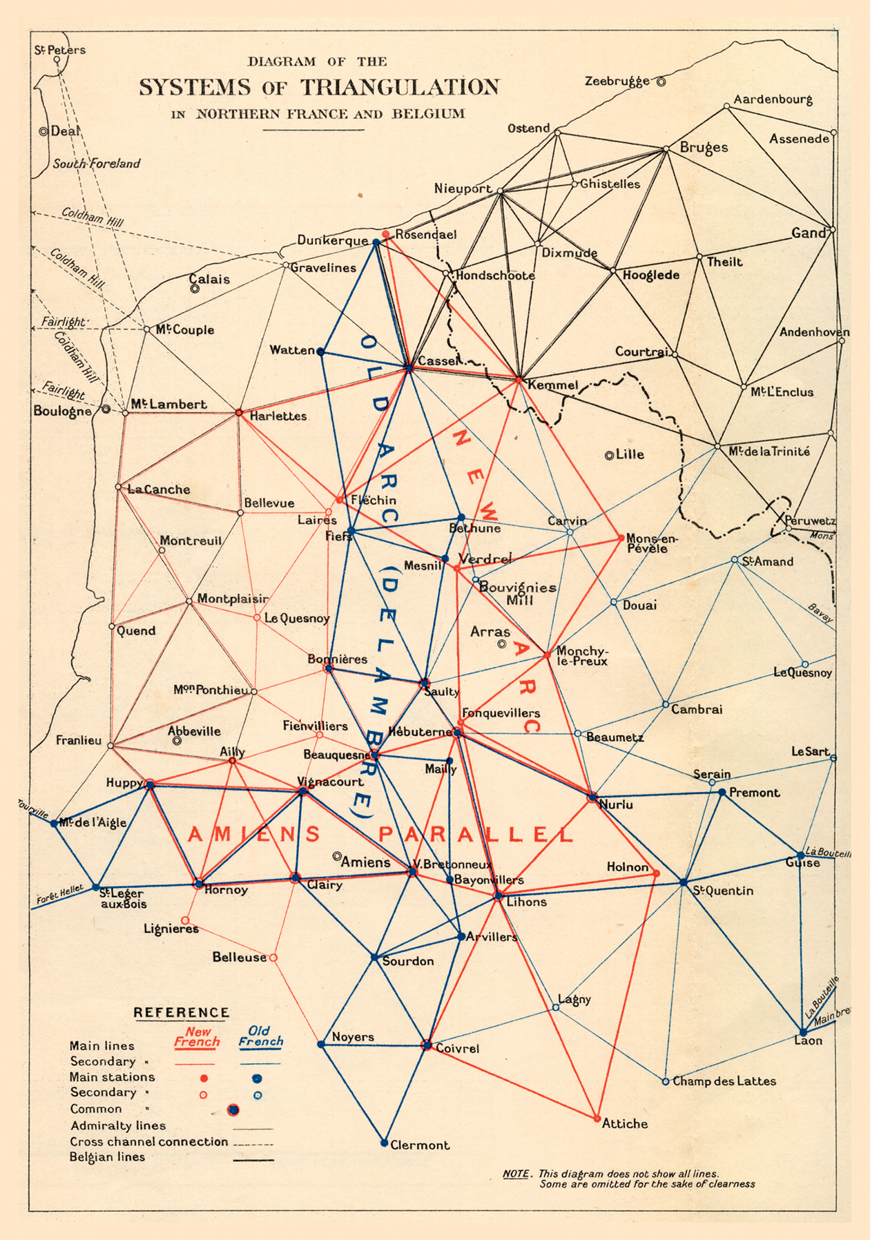
A simplified British Diagram of the Systems of Triangulation in Northern France and Belgium used by the British on the Western Front. Report on Survey on the Western Front , 1920.
The First World War was an industrial war, a war of material. Not for nothing did the Germans call the Somme battle the Materialschlacht . Mass production extended to maps. Millions of military maps were produced during the war, augmented by huge numbers of commercial maps, for politicians, statesmen and diplomats, for military, naval and air commanders and their staffs, for junior officers and NCOs (and occasionally every man in a sub-unit), for administrators and planners, industrialists and businessmen, newspapers and the general public. These totals represented an amazing variety of different types of maps world, national, topographical, naval and air charts, military maps (artillery, trench, traffic, going, etc.), propaganda, newspaper and commercial maps showing the war situation, and so on.
Font size:
Interval:
Bookmark:
Similar books «Mapping the First World War: The Great War through maps from 1914-1918»
Look at similar books to Mapping the First World War: The Great War through maps from 1914-1918. We have selected literature similar in name and meaning in the hope of providing readers with more options to find new, interesting, not yet read works.
Discussion, reviews of the book Mapping the First World War: The Great War through maps from 1914-1918 and just readers' own opinions. Leave your comments, write what you think about the work, its meaning or the main characters. Specify what exactly you liked and what you didn't like, and why you think so.