Foreword
For novices and geospatial experts alike, mapping technologies are undergoing as significant a change as has been seen since mapping first went digital. The prior introduction of Geographic Information Systems (GIS) and other digital mapping technologies transformed traditional map making and introduced an era of specialists in these new geographic technologies. Today, an even newer set of technological advancements are bringing an equally massive change as digital mapping goes mainstream. The availability of Global Positioning Systems (GPS), broadband Internet access, mass storage hard drives, portable devices, andmost importantlyweb technologies are accelerating the ability to incorporate geographic information into our daily lives. All these changes have occurred simultaneously and so quickly that the impact of only a fraction of the full potential of spatial technologies has yet been felt.
In parallel with the exciting opportunities that modern technologies are providing the digital geospatial universe, a less broadly known but perhaps far more important phenomenon has emerged: a new world of open source collaboration. Open source development and user communities, along with a healthy commitment from industry, are filling the growing need and demand for spatial technologies for making better decisions and providing more information to the growing mapping needs of technology users. In a multidimensional world, geography forms a common framework for disseminating information. The open source community and industry is filling that need at a growth rate unmatched in the industry.
In an age when web technologies have erased the distances between peoples of different continents and nationalities, this book and the technologies behind it remind us of the continued importance of place in the world in which we live. Mapping has always highlighted the differences and variations that occur over space; but at the same time it has reminded us that we share this world with our neighbors, and our actions have impact beyond ourselves. Hopefully, web mapping technologies will help to bring this powerful information to all of us for our common future good.
If you are reading this book without ever having heard of Geographic Information Systems or Remote Sensing, you are not alone. It is for you that the publishing of this book is so timely; it is now that mapping technologies are for the first time becoming readily accessible to the broader IT world. The incredible wealth of information provided in this book will allow you to interact with the open source mapping community as so many have already done, and will one day allow you to help the many others that will follow.
I hope that this book will, if nothing else, engage you in understanding the power that mapping information can bring to your web presence and other IT needsregardless of whether you are with an NGO, a small or large corporation, or a government organization. The importance of this book cannot be overstated. It comes at a critical stage, when two phenomena with tremendous momentum are coming together: the emergence of Open Source mapping technology, and the availability of technologies enabling digital mapping to become accessible by the masses.
Dave McIlhagga
President, DM Solutions Group
Preface
What is it about maps? For some of us, maps are intriguing no matter where we are. I've spent hours poring over them learning about foreign places. There is a sense of mystery surrounding maps. They contain information that can only be revealed through exploration.
Digital maps allow a user to explore even further by providing an interactive experience. Most maps have traditionally been static. Now digital maps allow users to update information and customize it for their particular needs.
Youthful Exploration
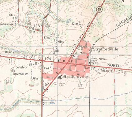
For me, map-based exploration started at a young age. I remember the thrill of finding our Scout camp on a topographic map. Part of the map is shown in . I found my home town, local roads, and even greenhouses. It was hard to believe that someone bothered to map the streets I used to play on or the tobacco fields I worked in during summer vacation. Yet there they were, drawn on this fascinating map that hangs on my office wall 20 years later.
These maps opened the door to planning hiking adventures and bicycle trips. I blame maps for luring me further and further away from hometo see what a map symbol or town looked like on the ground.
When I wasn't exploring, I was often on the computer learning more about the digital world. My combined interest in computers and exploration naturally led me to the field of computerized mapping and geographic information systems (GIS). It never occurred to me that my enjoyment of maps and computers would become a career.
Whether showing a friend where you live or displaying the path of a pending hurricane, maps play an important role in lives of people everywhere. Having the tools
Figure P-1. Part of the topographic map of my home town in southern Ontario, Canada; my home was located at the X symbol. Portions of NTS map sheets 40l/15c and 10c/15c 2005. Produced under licence from Her Majesty the Queen in Right of Canada, with permission of Natural Resources Canada.
and ability to map the world you live in is incredibly powerful. The following quote is from the Mayan Atlas:
Maps are power. Either you will map or you will be mapped. If you are mapped by those who desire to own or control your land and resources, their map will display their justifications for their claims, not yours.
Having open access to mapping tools further enables mapping efforts. Being able to share those maps with the world through web mapping makes the effort all the more worthwhile.
The Tools in This Book
The tools in this book are the results of a handful of open source projects. They are a critical set of tools in my professional data management toolbox. From visualizing map data to converting between formats, I have come to depend on many of them daily. They are also an important part of my future goals for mapping and data management.
These tools are a subset of what is available today, both in the mainstream commercial market and in the open source realm. Because these are open source, they are free for you to use and adopt as you see fit. Many of them are pushing the envelope of what even the commercial products can do.
I began using many of these tools shortly after finishing university. My day job was in mapping and geospatial data analysis, and I had access to some of the latest commercial tools. However, when I wanted to pursue projects at home on my own time, the traditional tools were simply not available. The licensing restrictions and costs forced me to find alternatives; eventually, the open source tools took over. Any gaps in my array of tools will likely be filled within a year of this book being published.
There is a lot of active development going on across the spectrum of open source mapping and GIS projects. Many projects use the latest open standards for interoperability and tend to implement them much faster than the commercial products.
My initial motivation for writing was to fill in the gaps of existing documentation and answer the new user's common questions. I hope it does this and more. I hope you become as excited about these tools as I am. Years of programming have given us a powerful toolkit for mapping, data management, and even youthful exploration.


