1.1 Introduction
The very first reference to the island of La Runion is found on a Portuguese planisphere from 1502 (known as the Cantinos Planisphere, a world map compiled by Portuguese explorers and cartographers). However, it is highly probable that Arab navigators, trading along the African coast, knew of the existence of this island, although it not was located on the traditional maritime routes of the Mozambique Channel . Several accounts exist of ships making stopovers on the western coast of La Runion for fresh water and food (fruits and various animals) at the beginning of the 17th century. After the French took possession of the island in 1642, they began colonizing it in 1663. The historical period of La Runions volcanic activity is thus restricted to a few centuries, and, as we will see below, observations of Piton de la Fournaise remained scarce until the 20th century.
1.2 Early Observations at the Beginning of the Islands Colonization
A comprehensive analysis of published and unpublished reports, private letters, administrative documents, and newspapers dealing with various observations of Piton de la Fournaise between the beginning of colonization and 1935 was carried out by Lacroix (). In this way thirty or so eruptions were reported, with more or less precision, during the 18th century, with four of them (1708; 1774; 1776; 1800) outside the Enclos Fouqu caldera and at least seven reaching the sea in the Grand-Brl. The state of the summit remained poorly known, except through a few visits.
The first reported visit to the summit of Piton de la Fournaise was made on September 20, 1751 by Andoche Dolnet de Palmaroux and a party composed of several Creoles and slaves (in dHerguerty , Vol. 3, p. 4) indicates that he read Dolnet de Palmarouxs report in a manuscript where a crude drawing showed a small, apparently active, vent beneath the summit. This latter may be the active vent observed by Frri in August.
In 1753, Piton de la Fournaise was visited by a group of 15 Creoles led by Jean Dugain (well known as a fugitive slave hunter). This expedition was requested by Jean Baptiste Charles Bouvet de Lozier, the governor of the island, following what was apparently a large eruption of the volcano. A short report is given by de Crmont () who does not provide the exact dates of the events. The eruption was associated with an earthquake , whose tremors were felt, and noticeable ash falls over a large part of the island (St. Benot, St. Denis). This suggests violent explosive activity at the summit, but we cannot rule out that what is described as cinders could in fact be Peles hair , because falls of Peles hair at a large distance from the volcano have been reported several times in the volcanos history. Dugain apparently made his observations from the rim of the Enclos. He described active lava flows in a large part of the western Enclos, eventually reaching the sea to the east.
The second visit to the summit was made on October 29, 1768 by a party comprising the governor and the intendant of the island (Lonard de Bellecombe and Honor de Crmont), three residents (Germain, Joseph Hubert and his younger brother Hubert de Monfleury), a guide (Jean Dugain) and 20 or so slaves. A report was published by de Crmont () as the Mamelon Central .
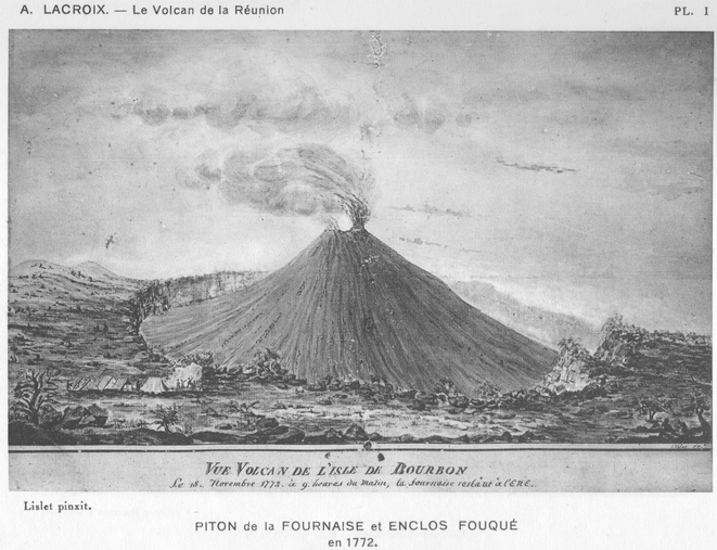
Fig. 1.1
Pencil sketch by Lislet-Geoffroy (reproduced in Lacroix ) showing the Enclos and the Central Cone as seen from the southwest in 1772
Two subsequent visits were made on November 18, 1772 (there is an ambiguity about the year, which could have been 1771, but we follow here the original publication that mentions 1772), and on October 29, 1791. In 1772, the expedition was carried out by Philibert Commerson, Honor de Crmont, and a 21-year old illustrator (Paul Sauguin de Jossigny), a 16-year old herbalist (Lislet-Geoffroy), and his father, a surveyor (Jean-Baptiste Bank), a notary (Philippe Leclerc de Saint-Lubin), a guide (Payet), four residents and 32 slaves (Lislet-Geoffroy , two craters were present at that time. On November 17, from Piton de Bert, the visitors clearly observed steam from the western one (Bory crater) and glowing ejecta from the eastern one (probably the one observed during the 1768 visit). The diameter of the latter was roughly estimated to be about 40 m. On November 18, they probably went down into the Enclos from Piton de Bert (on the southern rim of the Enclos Fouqu caldera) and Lislet-Geoffroy noted that the surface of the Enclos was covered by both smooth (pahoehoe) and rough (aa) lava flows . From the rim of Bory crater, they could observe steam flowing from fractures at the bottom of this crater and they had a view of the eastern crater, where the top of the lava column was close to the rim.
Hubert Dumorier and Patu de Rosemont attempted a new ascent in 1789, but they were trapped in bad weather and forced to abandon the expedition.
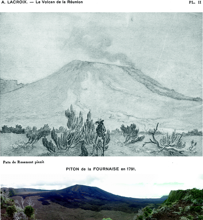
The October 1791 visit was motivated by the desire to explore the changes at the summit following major effusive and explosive activity (on July, 14) observed from the coast from June to July. The group was composed of Alexis Bert (a cultured military officer), Joseph Hubert, Jean-Joseph Patu de Rosemont, two guides and nine slaves. Their expedition is reported by Bert in an unpublished manuscript reproduced in Lacroix (, bottom). The cone to the east of Bory crater is not visible. The darker lava flows to the southeast of the Central Cone could be the 1791 lava flows.

