1. Introduction
Earth is a terrestrial planet whose history is recorded in rocks (Fig. ). Like fingerprints left at a crime scene, the evidence for past landscape-forming events is strewn about Earths surface hidden in canyons, on mountains, and beneath lakes and seas. This history hasnt always been recognized and only when Renaissance-era scientists began to use newly acquired tools and their newly acquired knowledge about natural Earth processes did they begin to seek out evidence, first for a Biblical flood, then for events on a much grander scale. Although no evidence for such a flood was found, the idea that Earths rocks contained evidence for its ancient past grew in the minds of these early scientists, setting them on a path that led to the development of the science of geology.
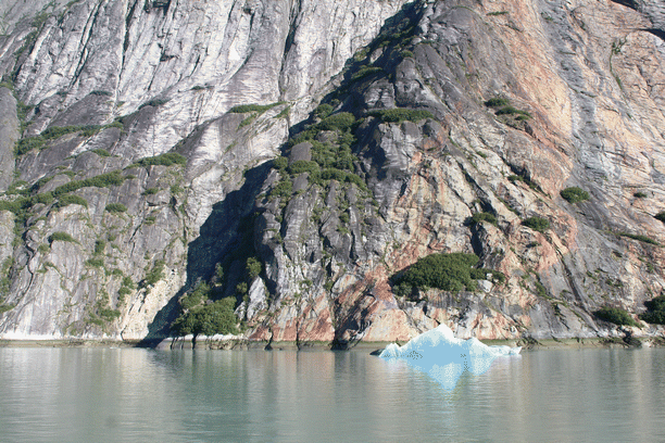
Fig. 1.1
The Cordilleran region is marked by spectacular rock outcrops. Seen here are plutonic and metamorphic rocks exposed by glacial scouring in a fjord in the Alaska Coast Range south of Juneau
Soon fossils were becoming categorized and a coherent sequence of evolved life forms emerged. Past mountain building events were recognized and numerous sub-branches of the discipline were developed, such as volcanology, sedimentology and glaciology. In the 1960s a 50-year-old hypothesis first suggested in 1915 by German geoscientist Alfred Wegner plate tectonics sprung to the forefront of geology as the dominant theory that could explain myriad Earth processes (a theory is the strongest level of acceptance in science short of a physical law). This great leap forward was given additional support with the publication of results from the International Geophysical Year (19571958) and since then plate tectonics has dominated the understanding and focus of research for geologists. This is especially applicable in explaining the structure and functions of the Earths interior, the non-random distribution of earthquakes and volcanoes, and the variable locations of the continents and oceans through time. Plate tectonics has evolved into a sophisticated paradigm that shows how the continents were assembled piecemeal by great and small collisions between sections or plates of its mobile, brittle crust (Fig. ). Every landscape on our planet, whether it is spectacular or not, holds clues to its formation and a coherent, if still developing, story can be known.
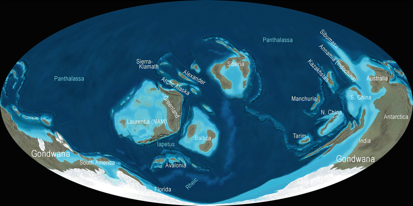
Fig. 1.2
The Earths plates were scattered across broad oceans in the Ordovician (ca. 450 Ma) but close inspection suggests that collisions were eminent as North America (labeled as Laurentia (NAM) closes on Baltica (center) with Siberia above. Gondwana occupied the South Polar region. Global maps are shown in Mollweide projection, an equal area map developed in 1805 by German mathematician Karl Mollweide and commonly used in atlases today. Mollweides map, which represents the whole world in an ellipse, has axes in a 2:1 ratio, and reflects the round character of the Earth better than rectangular maps
It is the truly spectacular landscapes however, that seem to draw the most attention from the public at large and from around the world people of all backgrounds are drawn to the iconic landscapes of the American West. They are poets, painters, filmmakers, thrill seekers, movie stars, rock stars, Asians, Europeans, Pacific Islanders, and just about anyone who has ever seen a cigarette ad or car commercial. But perhaps no one group comes to the American West with such vigor and intensity of observation as geologists, who seek out its hidden secrets from the ancient past. Here, in a still actively forming terrain lie the answers to the origin of a huge and rugged portion of the North American continent. Geologists cherish this relatively accessible and always tantalizing landscape, home to active volcanoes, continental-scale river systems, forested or sun-splashed shorelines, its canyons, deserts, mountains, and high-alpine valleys, that stretch from the Pacific shore to the Sierra Nevada and Cascade crest, across the Basin and Range to the Rocky Mountains and the Great Plains. The American West seems to have everything and is loved and revered by people worldwide.
The story you are about to read is complex in many of its details but can be understood and appreciated by those who merely have a sense of curiosity and wonder about it. By using the paleogeographic maps contained in this book, one can literally see the sequential development of the Western landscape and take a trip on a virtual time machine, revealing scenes that are long gone from planet Earth, but whose stories are preserved in its rocks. As our modern society advances, more and more people are able to visit these places, and the stories that geologists can share with them are richer and more complete. This is one of the first books to tell the vast and varied history of the American West through using visually attractive and state of the art paleogeographic maps (literally, ancient geography). Using these as a guide, one learns how the basement rocks of the region were cobbled together from volcanic islands that accreted onto North America over a mind-boggling 200-million-year time period. One sees how the area now occupied by the Rocky Mountains was covered not once in seawater but numerous times and most recently just 70 million years ago. And how parts of the Los Angeles basin were submerged beneath 600 m of water only 3 million years ago, and when volcanoes erupted, faults were generated, and canyons carved in the last few million years.
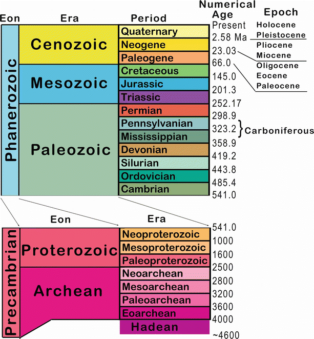
Before starting this geologic story, some descriptive terms will aid in the use of the maps and as you read the text. Throughout the book the abbreviation Ma is used for Mega-annum or millions of years ago. Similarly, Ga stands for Giga-annum or billions of years ago. Thus, very old events can be described as happening either thousands of millions of years ago or billions of years ago (1,750 Ma can also be written also as 1.75 Ga). Geologic time is divided into various Eons, Eras, Periods , and Epochs (Fig. ). There are three Eons, the Archean (4,0002,500 Ma), Proterozoic (2,500541 Ma), and Phanerozoic (541 Ma to Present) and it is often useful to refer to these large subdivisions of time. The geologic Eras may have a familiar ring to them including, Paleozoic (541252 Ma), Mesozoic (25266 Ma), and Cenozoic (66 Ma to Present). Perhaps not as familiar however, are the periods that belong in the Archean and Proterozoic Eons, with three in each and Paleo-, Meso-, and Neo- used as prefixes (i.e. Paleo-Archean , Meso-Proterozoic , etc.). The term Precambrian has no official standing in todays time scale but is still used when referring to the first 8/9th of earth history, or the time before complex life evolved, the base of the Cambrian.
Fig. 1.3
The modern geologic timescale (simplified)
The geologic Periods are the most widely used subdivisions of time and include names such as Cambrian , Permian, or Jurassic. Learning the names, sequence and age ranges for the time periods may seem tedious at first and perhaps even unnecessary. But anyone serious about moving forward in their quest to comprehend geology will need to have at least a rudimentary understanding of where the time periods are placed relative to each other, and for the important events that are often associated with them. The various geologic Epochs within each time period are used mostly by professional geologists, who find these more detailed subdivisions of time useful. The exceptions are the seven Epochs within the Cenozoic Era that are quite commonly used: Paleocene, Eocene, Oligocene, Miocene, Pliocene, Pleistocene and Holocene . Some geologists propose another Epoch, the Anthropocene , denoting the time of greatest human impact on Earth resources. It either replaces the term Holocene (the last 12,000 years) or it begins from the year 1950 and onwards when a steep rise in carbon emissions began.