Spatial Analysis
A Guide for Ecologists
Second Edition
Nowadays, ecologists worldwide recognize the use of spatial analysis as essential. However, because of the fast-growing range of methods available, even an expert might occasionally find it challenging to choose the most appropriate one. Providing the ecological and statistical foundations needed to make the right decision, this second edition builds and expands upon the previous one by:
- encompassing the basic methods for spatial analysis, for both complete census and sample data;
- investigating updated treatments of spatial autocorrelation and spatio-temporal analysis;
- introducing detailed explanations of currently developing approaches, including spatial and spatio-temporal graph theory, scan statistics, fibre process analysis, and hierarchical Bayesian analysis;
- offering practical advice for specific circumstances, such as how to analyze forest Permanent Sample Plot data and how to proceed with transect data when portions of the data series are missing.
Written for graduate students, researchers, and professionals, this book will be a valuable source of reference for years to come.
MARK R. T. DALE is the Provost of the University of Northern British Columbia, and Professor in the Ecosystem Science and Management Program. His research concerns the effects of interactions between plants on the spatial relationships of plants of different species in a community and the effects of population processes on the development of spatial pattern in the vegetation, as during succession. One main focus of research in the past twenty years has been the analysis of spatial structure in plant communities.
MARIE-JOSE FORTIN is Professor of Spatial Ecology in the Department of Ecology and Evolutionary Biology, University of Toronto. Her research focuses on the application of spatial ecology to fields of research such as conservation biology, ecotone detection, disturbance ecology, organismal dispersal, landscape genetics and functional connectivity of landscapes. She has been awarded the 2013 Distinguished Landscape Ecologist Award by the United States Chapter of the International Association for Landscape Ecology (US-IALE).
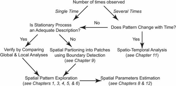
Decision-Tree of the Spatial Analyses Presented in the Book
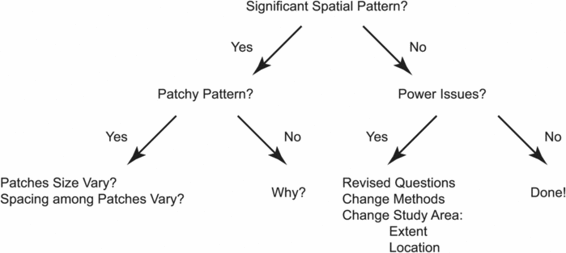
Key Questions to Ask while Analysing Spatial Ecological Data
Spatial Analysis
A Guide for Ecologists
Second Edition
Mark R. T. Dale
University of Northern British Columbia
Marie-Jose Fortin
University of Toronto
University Printing House, Cambridge CB2 8BS, United Kingdom
Cambridge University Press is part of the University of Cambridge.
It furthers the Universitys mission by disseminating knowledge in the pursuit of education, learning and research at the highest international levels of excellence.
www.cambridge.org
Information on this title: www.cambridge.org/9780521143509
First edition Marie-Jose Fortin and Mark R. T. Dale 2005
Second edition Mark R.T. Dale and Marie-Jose Fortin 2014
This publication is in copyright. Subject to statutory exception and to the provisions of relevant collective licensing agreements, no reproduction of any part may take place without the written permission of Cambridge University Press.
First published 2005
9th printing 2013
Second Edition 2014
Printed in the United Kingdom by TJ International Ltd. Padstow Cornwall
A catalogue record for this publication is available from the British Library
Library of Congress Cataloging in Publication Data
Dale, Mark R. T.
Spatial analysis : a guide for ecologists / Mark R.T. Dale, University of Northern British Columbia; Marie-Jose Fortin,
Univesity of Toronto. Second Edition.
pages cm
ISBN 978-0-521-19430-3 (Hardback) ISBN 978-0-521-14350-9 (pbk.)
1. EcologyStatistical methods. 2. Spatial analysis (Statistics) I. Fortin, Marie-Jose, 1958- II. Title.
QH541.15.S72F66 2014
577.015195dc23 2014000718
ISBN 978-0-521-14350-9 Paperback
Cambridge University Press has no responsibility for the persistence or accuracy of URLs for external or third-party internet websites referred to in this publication, and does not guarantee that any content on such websites is, or will remain, accurate or appropriate.
To Phyllis, John and Martha Ian
Contents
Preface
Spatial analysis has been a rapidly growing field in ecology for the past decade (e.g. since Fortin & Dale ). This growth derives from at least three factors: (1) an awareness among ecologists that spatial structure is an essential component in ecological thinking; (2) the all-too-obvious alteration of landscapes around us at an increasing rate, requiring constant re-evaluation of their spatial heterogeneity; and (3) the ready availability of software to perform many types of spatial analyses. One major problem with the broad availability of spatial analysis software is that it is easy to use them incorrectly. Incorrect application arises because: (1) ecologists are not fully aware of the issues of spatial scales; (2) ecologists are only slowly realizing the full implications of the prevalence of spatial autocorrelation in their data, which are usually not independent and thus violate the assumptions of standard statistics; and (3) ecologists are aware of the importance of spatial structure in the systems they study, but they are not yet familiar with the many different ways that spatial structure can occur in those systems. In part, that is why we need to go beyond narrowly defined spatial statistics into the broader area of spatial analysis more generally. The purpose of this book is therefore to provide a bridge between the current understanding of the need for spatial analysis and the uncertainty of many ecologists on how to perform and interpret these kinds of analysis.
The motivation for this book is to introduce ecologists to a large array of methods available for spatial analysis. The scope of this book is quite broad, not as specialized as Dale (). We hope that we provide sufficient detail for ecologists to apply and understand the methods. We do not cover all the methods that have ever appeared; we have been selective, but we have tried to go beyond what is readily available in the ecological literature, and to include references from fields such as geography, geology and epidemiology, where appropriate.
Most ecological questions are aimed at understanding the complexity of nature and how it works, by testing hypotheses about ecological processes, their context, and their interactions. This knowledge-building is based on observation, pattern detection, experimentation, and modelling. Hence for ecologists, pattern recognition is only one step in a series of steps to disentangle the complexities of natural systems. Thus, the ecological motivation for performing spatial analysis is to detect pattern, but that is only the beginning of answering bigger questions. Ecologists want to understand the process that generates the pattern. Geographers are like ecologists in that the description of the phenomenon is of interest, but not the final goal. Epidemiology is essentially applied ecology: looking for pattern to find the process. The classic example is John Snows study in the 1850s that used the spatial pattern of disease incidence to determine that the Broad Street pump in London was the source of a cholera outbreak (cf. Haining ). Identifying the pattern leads to an understanding of the system that gave rise to it. In ecology, however, many of the puzzles are of much greater complexity than tracing the source of disease. Consider the complexities of the processes that give rise to the spatial arrangement of 20 species of tree in a temperate forest and then those for a tropical forest with hundreds of tree species and then all the insects in the tropical forest.

