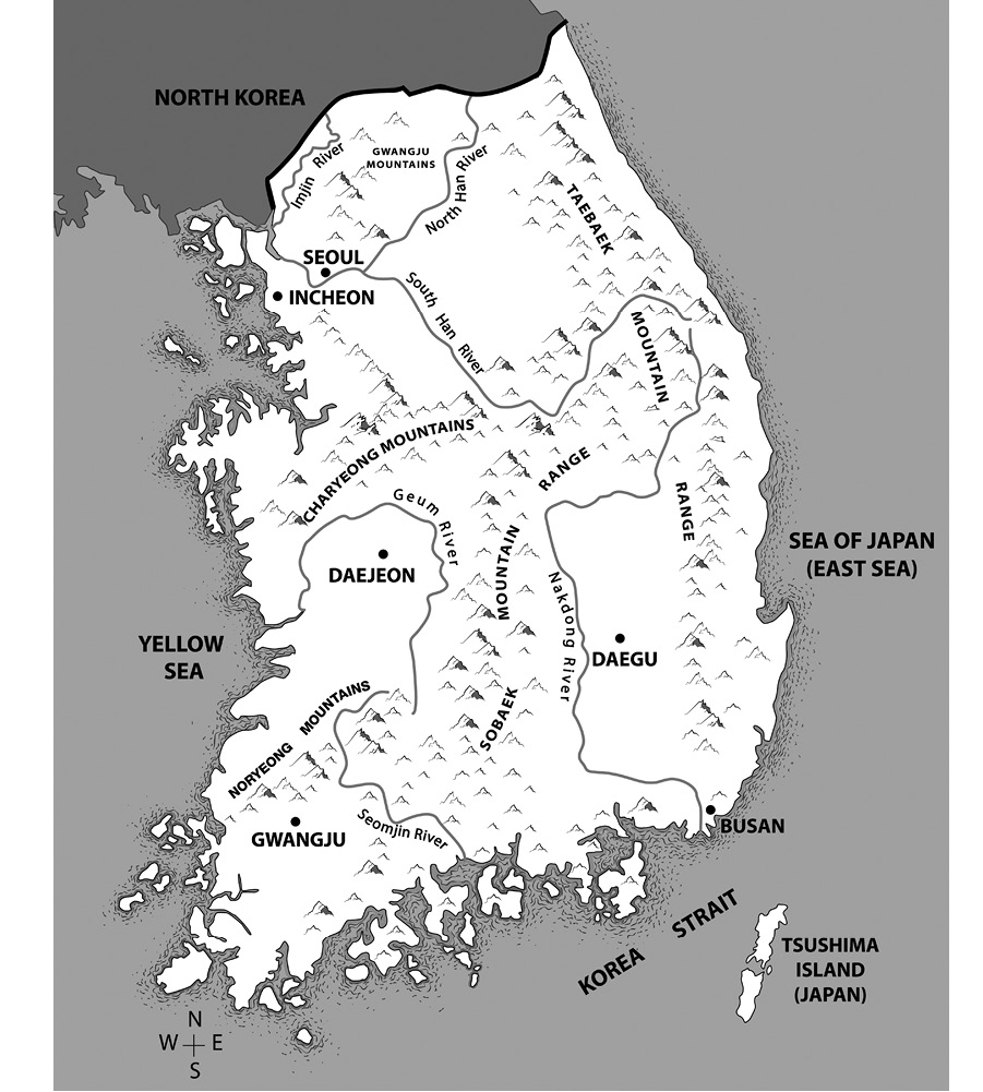
Map by Jing (Vera) Chen and Jing Yun (Joyce) Tao.
Chapter 1
A young U.S. soldier our security escort into Panmunjeom stepped on the tour bus and walked slowly up the aisle, handing out identification tags to me and each of the forty or so other Westerner tourists aboard. His name tag read Sergeant Naumenkof. Hewas wholesome-faced and sleepy-looking, and spoke with a slow Midwestern American drawl. I envisioned him working on a farm in Kansas rather than aiming a rifle toward North Korea.
These ID tags must be prominently displayed on your jackets at all times, he announced. There will be no flash photography. Turn off your cellphones.
We were parked in front of Camp Bonifas. Two and a half kilometres north were Panmunjeom and the Joint Security Area, which formed the border between North and South Korea. The Washington Post described Camp Bonifas as a small collection of buildings surrounded by triple coils of razor wire just 440 yards south of the DMZ [demilitarized zone], which, minus minefields and soldiers, resembled a big Boy Scout camp.
It was true; the camps entrance was utilitarian, like one of those cut-rate summer camps your parents sent you and your sister to when you were ten years old. But looks can be deceiving. Camp Bonifas is the base for the United Nations Command Security Battalion, comprised of a crack contingent of approximately six hundred men, 60 percent of whom are Republic of Korea (ROK) soldiers, the rest American; though to get a confirmation of precise numbers in this high-risk security area can be a challenge. The battalion provides protection in the JSA for visiting military officers, government officials, other guests, and most important today, for me! These soldiers are in a constant state of readiness; one never knows when the belligerent and unpredictable North Korean border soldiers might act up.
* * *
Four hours earlier, our bus had departed Seoul from Yongsan Garrison, headquarters for the United States Forces Korea (USFK), which is responsible for organizing, training, and supplying approximately twenty-eight thousand American troops on the Korean peninsula. The mid-April morning was cold and miserable, a shroud of mist clinging to the ground and a hard, slanting rain falling. Our bus proceeded northwest out of the city toward Panmunjeom, sixty kilometres away. En route, we passed the satellite city of Ilsan, where a staggering number of white high-rise apartment blocks dominate the skyline. We then travelled into the fertile Paju lowlands, formed by the Imjin River basin. The land here is sectioned into small rectangular plots where predominantly rice is grown between the pockets of low, wooded hills. These hills are part of the Gwangju mountain range, an outlier of the grand Taebaek range that rises in the east. The mountains surround Seoul to the north, east, and west, and the ridges, peaks, and steep hills are a picturesque feature of the city.
The bus travelled north onto the Freedom Expressway, which parallels the eastern shore of the indomitable Han River. The windows were so fogged up that we needed to constantly wipe them to be able to see out. The expressway was wide, modern, and for the most part devoid of vehicles due to its proximity to the North Korean border if youre not a soldier based in the area, a local farmer, or a tourist visiting Panmunjeom, there really isnt any reason for you to be there.
Our route followed the general path of the river, which flows northwest out of the capital and is joined forty-five kilometres downriver by the Imjin, which flows southwest from North Korea. In the pelting rain, the Imjin that day was swollen, yellow, and wide. Just a few kilometres north, on the other shore, is North Korea. No vessels are permitted to ply the river here due to security concerns.
We soon approached the area of Imjingak and the Unification Bridge that spans the Imjin River. Just south of here is Munsan village. Munsan Station is the last rail stop on the regular Gyeonggi Rail Line, which runs north from Seoul. A special DMZ train that is designated for sightseeing begins in Seoul, continues the short distance from Munsan to Imjingak Station, then crosses Freedom Bridge just south of Unification Bridge and culminates about a kilometre and a half north at Mount Dora Observatory, where passengers can look out over the DMZ. No civilian vehicles are permitted north of the Imjin River.
After crossing Unification Bridge, we entered the Civilian Control Zone (CCZ), a restricted area that runs south of and along the entire length of the 250-kilometre-long DMZ. Within this coast-to-coast corridor are security checkpoints and military personnel and hardware, including tanks, attack helicopters, and rocket launchers. East of us are two long southnorth passes that move through the Gwangju Mountains, one reaching north from Seoul through the cities of Uijeongbu, Dongducheon, and Yeoncheon to the border. Along this route there are several military camps, temporary home for an ever-changing number of ROK and U.S. soldiers. When North Korea launched its assault against South Korea on June 25, 1950, triggering the Korean War, many of its troops marched south into Seoul through this corridor.


