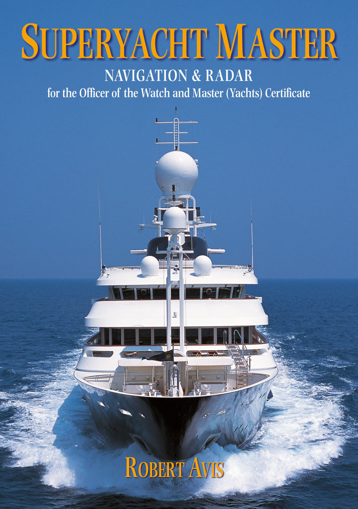
Avis - Superyacht Master
Here you can read online Avis - Superyacht Master full text of the book (entire story) in english for free. Download pdf and epub, get meaning, cover and reviews about this ebook. publisher: Bloomsbury Publishing, genre: Children. Description of the work, (preface) as well as reviews are available. Best literature library LitArk.com created for fans of good reading and offers a wide selection of genres:
Romance novel
Science fiction
Adventure
Detective
Science
History
Home and family
Prose
Art
Politics
Computer
Non-fiction
Religion
Business
Children
Humor
Choose a favorite category and find really read worthwhile books. Enjoy immersion in the world of imagination, feel the emotions of the characters or learn something new for yourself, make an fascinating discovery.
Superyacht Master: summary, description and annotation
We offer to read an annotation, description, summary or preface (depends on what the author of the book "Superyacht Master" wrote himself). If you haven't found the necessary information about the book — write in the comments, we will try to find it.
Superyacht Master covers the requirements of the navigation and radar modules for the Officer of the Watch (Yachts) and the Master (Yachts) Certificates required for captains and crew of commercial yachts over 24m and under 3,000 tons. It is the only book written specifically for these modules and will be required reading for all those undertaking a deck career in the superyacht industry or in similar sized commercial craft.
This book is intended for the next level of navigators after Yachtmaster and is an extension of the current series of very successful and highly regarded course instruction books available from Adlard Coles Nautical.
At long last someone has written an in-depth reference manual on radar operation for the masters of large yachts. Every superyacht should have a copy on the bridge! John Wyborn, Director, The Crew Training Centre, Antibes
Avis: author's other books
Who wrote Superyacht Master? Find out the surname, the name of the author of the book and a list of all author's works by series.


Superyacht Master — read online for free the complete book (whole text) full work
Below is the text of the book, divided by pages. System saving the place of the last page read, allows you to conveniently read the book "Superyacht Master" online for free, without having to search again every time where you left off. Put a bookmark, and you can go to the page where you finished reading at any time.
Font size:
Interval:
Bookmark:
To my very best friend who
now knows far more about
superyacht navigation and radar
than she ever really wanted to know!

One of the most important task of an Officer of the Watch is to keep a good lookout on the bridge. Having assessed if a risk of collision exists, the OOW and Master must then correctly interpret the rules of the road and take the right avoidance action. He needs to have a clear understanding of all the tools that he has to hand one of the most important being radar.
In writing this book Robert Avis has not only given clear revision of navigation techniques for students on the OOW, Masters Navigation and Radar courses but has provided extensive explanatory notes for the collision rules and exceptionally clear guidance for radar interpretation. To quote the Director of Lairdside Maritime Centre, John Moores University, Liverpool:
Supported by good examples and advice, this book provides invaluable reference material for those attending the Navigation and Radar Course.
The author, Robert Avis, served a long apprenticeship at sea. He commanded 12 ships and completed some 50,000 sea miles with the Royal Naval Reserve. He rose to the very highest levels in that organisation, commanding HMS President in London. During the last ten years he successfully guided numerous students through their MCA Class 4 courses, and oral preparation. A very charming, witty man with a wealth of knowledge, Roberts brisk and dynamic teaching style held his classes spellbound.
Sadly Robert died from a long illness before the final publication of this book, but it is a lasting tribute to his knowledge, enthusiasm and professionalism. He will be very sadly missed by all who knew him.
Martin Pound MRIN
THE EARTH IS THE FIFTH-LARGEST PLANET in our solar system (after Jupiter, Saturn, Uranus, and Neptune). Its mass is about 5.98 x 1024kg and with an average density of 5520kg/m3 (water has a density of 1027kg/m3). It is the densest planet in our solar system.
The Earth's axis is tilted from the perpendicular to the plane of the ecliptic by an angle of around 23.5. (It was 23 26' 20" in 2000. This amount reduces by 0.47 of a second each year!) Since the axis is tilted, different parts of the globe are orientated towards the sun at different times of the year. This tilting creates the four seasons of the year: spring, summer, autumn and winter.
More importantly to the navigator, the Earth itself is not a perfect sphere. It is often described as an oblate spheroid, but to be strictly correct it isnt even that. However in order to create a basis upon which navigational calculations can be made, it is generally accepted to be an oblate spheroid, that is to say a football that has been sat upon. If you are a bit of an anorak, the polar radius is 3432.4 nautical miles (nm) (6356.8km) and the equatorial radius is 3443.9nm (6378.1km), the difference being 11.5nm (21.3km) in radius or 23.0nm (42.6km) in diameter.
Until the end of the 15th century, sailors navigated with continuous reference to land. In the Mediterranean it was easy to stay in touch with land masses, and in western and north-west Europe, navigation was entirely coastal. Ships followed the shore from Gibraltar to Norway and the Baltic. The rare exception to this rule was the trade that developed between Scandinavia, Iceland, and Greenland following the discovery of these routes by the Vikings around 1000AD.
When the Portuguese set off on voyages of discovery in the 15th century, navigation became more complex. Portuguese sailors followed the coast of Africa, as they carefully explored southwards. The only reference points available apart from land were heavenly bodies. Locations and courses had to be spatial: navigators needed to be able to locate themselves on a grid of imaginary lines that they developed and later became known as latitude and longitude.
Latitude and longitude

Latitude, which gives the location of a position north or south of the Equator, is expressed by angular measurements ranging from 0 at the Equator to 90N or 90S at the Poles.
Midway between the North and South Poles, the Equator the only east/west great circle divides the Earth into northern and southern hemispheres. Running parallel to the Equator, to the north and to the south of it, are a succession of imaginary circles that become smaller and smaller the closer they get to the Poles. This series of east-west-running circles, known as the parallels of latitude, are crossed at right angles by a series of half-circles extending north and south from one Pole to the other, called meridians of longitude.
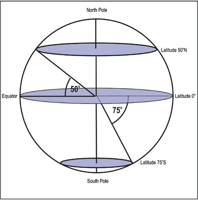
Fig 1.1 Latitude.
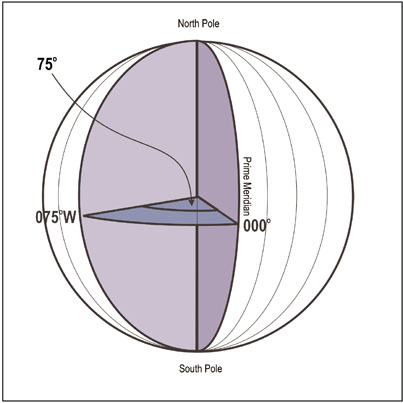
Fig 1.2 Longitude.
Degrees of latitude are equally spaced, but the slight flattening of the Earths shape at the two Poles causes the length of a degree of latitude on the Earths surface to vary from 59.7nm (110.57km) at the Equator to 60.3nm (111.70km) at the Poles. One minute of latitude (1/60 of a degree) is taken to equal a nautical mile (nm), but because of the differences between the measured distance at the Equator and at the Poles, this distance of a nautical mile is taken as one minute of latitude at that latitude.

When measuring distance on a chart, always measure from the position on the latitude scale that is level with your position.
Longitude is the measurement of a position east or west of a single north/south line, now known as the prime meridian. Because for many years, different countries designated their own prime meridians, it was difficult to specify positions on an international basis and so, in 1884, an internationally accepted prime meridian was established through Greenwich in Greater London in the United Kingdom, thus giving an internationally accepted basis against which longitude could be measured. Longitude is therefore measured in degrees ranging from 0 at the prime (Greenwich) meridian up to 180 east or 180 west. The meridian opposite to the prime meridian is the basis for the International Date Line. It is this point which determines the change of the date when travelling from west to east. The International Date Line itself is actually not a meridian in the true sense as it has been set up by International agreement and varies in longitude to include and exclude various countries on each side of itself.
You cannot measure distance using the longitude scale as, although meridians of longitude 1 apart at the Equator are in fact separated by a distance of 60.1nm (111.32km), as they converge towards the North and South Poles, the distance between each degree decreases down to zero at each Pole.
It is vitally important NOT to measure distance off the longitude scales as the measured distance of one minute of longitude decreases as you move north in the northern hemisphere or south in the southern hemisphere.
Next pageFont size:
Interval:
Bookmark:
Similar books «Superyacht Master»
Look at similar books to Superyacht Master. We have selected literature similar in name and meaning in the hope of providing readers with more options to find new, interesting, not yet read works.
Discussion, reviews of the book Superyacht Master and just readers' own opinions. Leave your comments, write what you think about the work, its meaning or the main characters. Specify what exactly you liked and what you didn't like, and why you think so.