DULUTH
DULUTH
An Urban Biography
TONY DIERCKINS


Cities, like people, are always changing, and the history of that change is the citys biography. The Urban Biography Series illuminates the unique character of each city, weaving in the hidden stories of place, politics, and identity that continue to shape its residents lives.
Copyright 2020 by Tony Dierckins. Other materials copyright 2020 by the Minnesota Historical Society. All rights reserved. No part of this book may be used or reproduced in any manner whatsoever without written permission except in the case of brief quotations embodied in critical articles and reviews. For information, write to the Minnesota Historical Society Press, 345 Kellogg Blvd. W., St. Paul, MN 551021906.
mnhspress.org
The Minnesota Historical Society Press is a member of the Association of University Presses.
Manufactured in the United States of America
10 9 8 7 6 5 4 3 2 1
The paper used in this publication meets the minimum requirements of the American National Standard for Information SciencesPermanence for Printed Library Materials, ANSI Z39.481984.
International Standard Book Number
ISBN: 978-1-68134-159-0 (paper)
ISBN: 978-1-68134-160-6 (e-book)
Library of Congress Cataloging-in-Publication Data
Names: Dierckins, Tony, author.
Title: Duluth : an urban biography / Tony Dierckins.
Description: Saint Paul : Minnesota Historical Society Press, 2020. | Includes bibliographical references and index. | Summary: In this richly textured urban biography, author Tony Dierckins highlights fascinating stories of the city of Duluth, Minnesota: Its significance in the Ojibwe peoples migration. The failed copper rush along Lake Superiors North Shore that started the citys growth. The natural port on the St. Louis River that made shipping its first and most important business. The legend of the digging of the ship canal. The unique aerial transfer bridge and its successor, the lift bridge. The citys remarkable park system. The 1920 lynching of three African American circus workers. The Glensheen murders. The evolution of the citys east-west divide. Throughout the years, the big lake and river have sustained Duluths economy, shaped its residents recreation, and attracted the tourists who marvel at the citys beauty and cultural lifeProvided by publisher.
Identifiers: LCCN 2019057545 | ISBN 9781681341590 (paperback) | ISBN 9781681341606 (ebook)
Subjects: LCSH: Duluth (Minn.)History.
Classification: LCC F614.D8 D535 2020 | DDC 977.6/771dc23
LC record available at https://lccn.loc.gov/2019057545
This and other Minnesota Historical Society Press books are available from popular e-book vendors.
For
MARYANNE C. NORTON
Contents
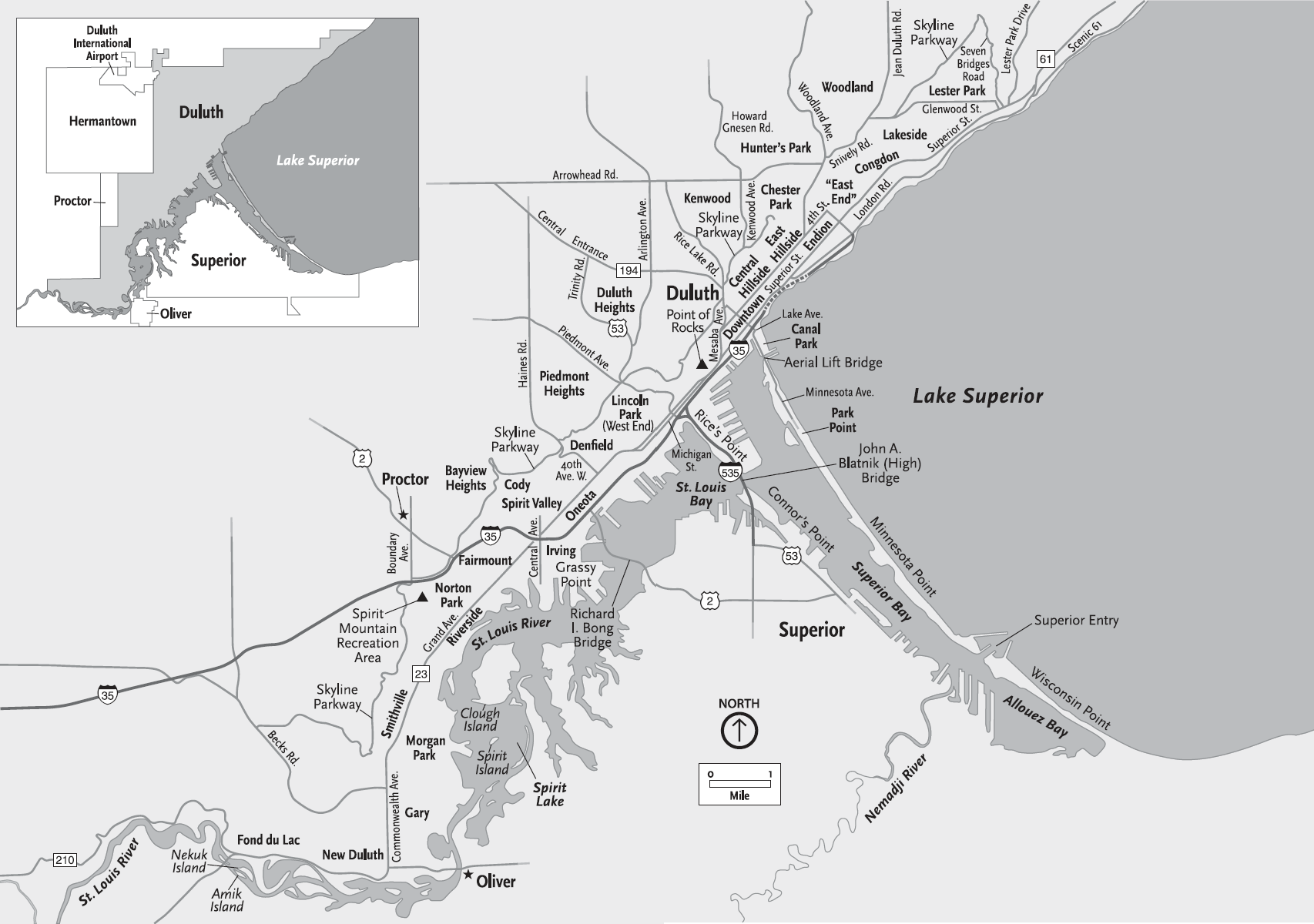
Map by Matt Kania, Map Hero Inc.
Prologue
Duluth, Minnesota, sits perched at the western tip of the Great Lakes, running twenty-eight miles along the northern shorelines of Lake Superior and its largest tributary, the St. Louis Riverwaterways that have profoundly shaped the city, not just geographically, but economically and culturally as well. By 1700 the natural harbor they formed provided a home for Ojibwe residents. In the mid-1800s, as the nation expanded westward, that harbor attracted those who saw its future as a great shipping center. The name Duluthchosen to commemorate an ambitious and often arrogant seventeenth-century French soldier who once portaged over a sandbar separating the lake and riverfirst appeared on maps in 1856. Its strategic position and the surrounding regions abundant natural resources would help Duluth ride out dramatic economic ebbs and flows created by waves of panic, depression, and recession. Once a railroad arrived, wharves and docks blossomed along the bay, soon joined by warehouses, factories, and mills. Upstream, the rivers rapids later turned turbines, producing the electricity that powered industry. Beyond acting as an anchorage for manufacturing and trade, the lakes and rivers waters also provided food and offered endless recreational opportunities and natural beauty that have persistently drawn visitors to their shores. But those waters carried challenge and conflict as well, leaving little room to develop infrastructure, fueling a feud with Duluths neighbor across the bay, and creating a geographic split that to this day divides the city economically and politically. And so the story of Duluth beginsand continueswhere the lake and river converge.
CHAPTER 1
Before Duluth (To 1850)
The First Peoples
Lake Superior has drawn people to its western shores for millennialong before anyone thought to name a community centered on its convergence with the St. Louis River Duluth.
We cant know what the first peoples called themselves, but archaeologistswho name cultures and describe them by the artifacts they leave behindrefer to the people who first moved to the area about fourteen thousand years ago as Paleo-Indians. They hunted large game, including mastodons, at the end of the last Ice Age. About 7000 BCE, as the weather warmed, the large game died out, other foods became more plentiful, and the Eastern Archaic culture arose. People thrived along the developing Great Lakes, hunting a broad range of game with more effective tools, including some made of copper mined on Michigans Keweenaw Peninsula and Isle Royale. Three thousand years ago, Woodland mound-building cultures followed; people grew corn, beans, and squash, made pottery, and established seasonal village sites.
By 1600, when European explorers began to write about the area, the people living in what is now northern Minnesota called themselves Dakota; their neighbors were the Assiniboine and Cree. The Dakotathe regions largest group, with a significant population on central Minnesotas Lake Mille Lacsunderstand that they have always lived in what is now Minnesota. Dakota origin stories hold that the Dakota came from the stars. Most anthropologists believe that they are descended from the Woodland people.
Formed by Fire and Ice
The forces that shaped Duluths geography occurred during the planets formation several billion years ago, in the Precambrian era. Basalt and granite found along Lake Superiors western shore indicate volcanic and seismic activity, and according to geologist John C. Green, the landscape once featured great mountain ranges, perhaps rivaling the Alps, which have since been eroded to the nub. Sandstone and slate deposits along the lakes south shore and up the St. Louis River to Cloquet speak of a vast sea that once covered the region. More volcanic eruptions and earthquakes were followed by more erosion.
About 1.8 million years ago a giant plume of molten rock melted and spread as it neared the surface, creating cracks in the earths crust that allowed magma to burst through in what Green describes as huge fountains of intensely glowing lava spurting up from fissures that extended for miles across a barren plain forming a huge, pancake-like lava flow that spread for 24 million years.
The result was the Midcontinent Rift System, a geologic feature portions of which have been mapped in a dozen US states, with southern Ontario at its apex and stretching as far south as Oklahoma and Mississippi. Lake Superior sits near the top. As volcanic activity subsided, the heavy basalt it produced sank at the basins center, forming a shallow sea that over the eons filled with sediment carried by streams, eventually creating a hard basalt bowl filled with soft sandstone. The region then stabilized until about two million years ago, when it started getting cold and fire finally gave way to ice.
Next page
