Library and Archives Canada Cataloguing in Publication
Berger, Antony R., author
The good and beautiful bay : a history of Bonne Bay to Confederation and a little beyond / Antony Berger.
Includes bibliographical references and index.
Issued in print and electronic formats.
ISBN 978-1-77117-338-4 (pbk.).--ISBN 978-1-77117-339-1 (epub).-
ISBN 978-1-77117-340-7 (kindle).--ISBN 978-1-77117-341-4 (pdf)
1. Bonne Bay (N.L.)--History. 2. Bonne Bay (N.L.)--Genealogy. I. Title.
| FC2195.B67B47 2014 | 971.8 | C2014-902090-2
C2014-902091-0 |
2014 by Antony Berger
ALL RIGHTS RESERVED. No part of the work covered by the copyright hereon may be reproduced or used in any form or by any meansgraphic, electronic or mechanicalwithout the written permission of the publisher. Any request for photocopying, recording, taping, or information storage and retrieval systems of any part of this book shall be directed to Access Copyright, The Canadian Copyright Licensing Agency, 1 Yonge Street, Suite 800, Toronto, ON M5E 1E5. This applies to classroom use as well.
PRINTED IN CANADA |
 | This paper has been certified to meet the environmental and social standards of the Forest Stewardship Council (FSC) and comes from responsibly managed forests, and verified recycled sources. |
Cover Design by Graham Blair Illustrated by Albert Taylor
FRONT COVER: View looking across Bonne Bay from above Woody Point (lower left corner) to Norris Point and Neddy Harbour with Gros Morne looming in the background (2013 photo by Philip Rendell).
BACK COVER: This watercolour of South Arm was painted by Frances Musgrave in 1866, and is reproduced from the original in the National Library and Archives Canada, Ottawa (accession number 1958-34-6, item 6, negative 46835). The notation on the bottom reads Entrance to Bonne Bay, Woody Point.
F LANKER P RESS L TD.
PO B OX 2522, S TATION C
S T . J OHNS , NL
C ANADA
TELEPHONE: (709) 739-4477 FAX: (709) 739-4420 TOLL-FREE: 1-866-739-4420
WWW.FLANKERPRESS.COM
9 8 7 6 5 4 3 2 1

We acknowledge the financial support of the Government of Canada through the Book Publishing Industry Development Program (BPIDP) for our publishing activities and the Government of Newfoundland and Labrador, Department of Tourism, Culture and Recreation. We acknowledge the support of the Canada Council for the Arts, which last year invested $157 million to bring the arts to Canadians throughout the country. Nous remercions le Conseil des arts du Canada de son soutien. Lan dernier, le Conseil a investi 157 millions de dollars pour mettre de lart dans la vie des Canadiennes et des Canadiens de tout le pays.
In memory of
Ella Manuel
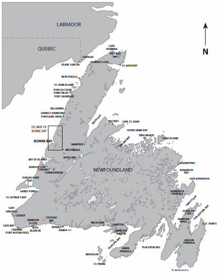
Map of the island of Newfoundland, showing place names mentioned in the text. From 1713 to 1783, the French Shore extended from Cape Bonavista north to Cape Norman and thence to Pointe Riche by Port au Choix. From 1783 to 1904, it covered the coastline from Cape Ray around the Northern Peninsula to Cape St. John.
Contents
Chapter
INTRODUCTION
A lovelier scene cannot be imagined. Great hills in the foreground and beyond; mountains peeping over each others shoulders; and away up in the blue sky the snow sparkled on the higher storm-lashed peaks, which reared their heads far inland, all robed in a beautiful transparent atmosphere unknown elsewhere. To the north the hills were bare, rugged, precipitous; but on that particular morning the glorious sunshine made them lose half their desolate bleakness.
BONNE BAY IN HISTORY
One of the most scenic and oft-visited places in all of Atlantic Canada is Bonne Bay. This double-armed fjord and its seaside communities lie at the heart of Gros Morne National Park. The Bay occupies an important place in the history of Newfoundland and Labrador. Tensions between the French and British, who had competing claims along the coast, were often played out in Bonne Bay. It was for many decades in the 1800s and early twentieth century the administrative centre for the northwest coast of the island, and sometimes claimed to be the capital of the West Coast. Whether one sailed from St. Johns around the Northern Peninsula or along the South Coast, Bonne Bay was about equidistant. Though more people now live on the north side of the Bay in Rocky Harbour and Norris Point, in earlier times Woody Point, on its south side, was the regional centre for fishing, commerce, and public services.
As the twentieth century progressed and the pulp and paper industry was established in Corner Brook, Bonne Bay decreased in importance. The establishment in the late twentieth century of the Park and its designation as a United Nations World Heritage Site did much to reverse this trend. Today, Bonne Bay is one of Eastern Canadas most popular tourist destinations, visited by people from all over the world. Commerce has retreated in the face of natures gifts. In a province rich in natural and cultural wonders, Bonne Bay and its surrounds remain a clear favourite. The Bay lies at the base of the Northern Peninsula, and marks the sudden change from steep coastal cliffs and mountains to the south, to a low-lying coastal plain to the north. Inland from this plain, which continues most of the way to the northern tip of the island, are the majestic mountains of the Long Range. These are cut by a number of steep-sided, mostly landlocked valleys, the best-known of which, Western Brook, lies just north of Bonne Bay. The lower elevations around the Bay are forested, but the best timber is to be found on its south side, one reason why the centre of early settlement was here.
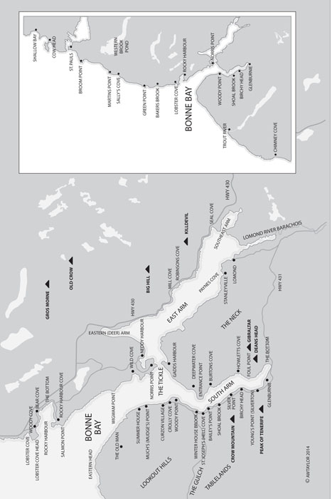
The main towns of the BayRocky Harbour, Norris Point and Woody Point, together with the modern municipal triad of Glenburnie-Birchy Head-Shoal Brookhave each played a role in the social and economic development of the area, as did the now-vanished settlement of Lomond. Today, Rocky Harbour is the administrative centre of the Park, while Woody Point hosts its main interpretation facility, the Discovery Centre. Norris Point is home to a nationally important marine research and interpretation centre. Around the Bay, there are now a number of thriving businesses based on tourism, fishing, and transportation, and there are several annual literary, music, and folk festivals.
The only detailed account of the historical development of Bonne Bay published to date is James Candows 1998 book Lomond: The Life and Death of a Newfoundland Woods Town. My mother, the late Ella Manuel, a well-known Newfoundland writer and broadcaster, compiled a short history entitled Woody Point 1800-1900. This was privately printed in 1972 as an undated eighteen-page pamphlet with a loosely enclosed map of South Arm of Bonne Bay. It was sold at local outlets until copies ran out in the late 1980s. Roy Osmond produced in 1987 an invaluable study,
Next page
![Jon Bonné - The New French Wine [Two-Book Boxed Set]: Redefining the Worlds Greatest Wine Culture](/uploads/posts/book/443558/thumbs/jon-bonn-the-new-french-wine-two-book-boxed.jpg)


