Acknowledgments
I HAVE RELIED ON the kindness of both strangers and friends in researching and writing this book, and one of the happy results is that many of those strangers are now friends. I owe a great deal to my agent, Rafe Sagalyn, who helped me understand this as a broad rather than a narrow book; to many of my colleagues at The Atlantic Monthly in Boston, who provided me with much wise counsel as I embarked on this project; to my parents, Jim and Valerie, and my sister, Alison, experienced book writers all, who have helped and guided me in more ways than I can express; and to my aunt, Jane Lester, who regularly provided me with a most welcome pied--terre in Washington during my visits to the Library of Congress. Im indebted to the entire wonderful staff at Free Press, especially Ellen Sasahara, the books designer, and my two editors: Bruce Nichols, with whom I began the book, and Hilary Redmon, who has seen it through to completion with a rare mix of enthusiasm, insight, and sensitivity. Special thanks also go to three other Free Press staffers: Carol de Ons for her admirably thorough and thoughtful copyediting, Sydney Tanigawa for all of her help in shepherding the book through production, and to Jill Siegel, for guiding me so ably through the unfamiliar waters of book promotion.
Among those I accosted for help and expert guidance as I researched and wrote this book are Peter Barber, Danny Barenholz, Theodore Cachey, Tony Campbell, Yelitza Claypoole, Alan Cooper, Susan Danforth, Carol Delaney, Anthony Grafton, Ernesto Guerra, Felipe Fernndez-Armesto, Ronald Grim, Kathy Hayner, Brian Jay Jones, Robert Karrow, Corby Kummer, Hans-Jrg Knast, Jill Lepore, R. Jay Magill, Berndt Mayer, An Mertens, Peter Meurer, Thomas Nadler, Benjamin Olshin, Kieran OMahony, Monique Peletier, John Pike, Richard Ring, Albert Ronsin, Sara Schecter, Felicitas Schmeider, Benjamin Schwarz, Zur Shalev, Rodney Shirley, Larry Silver, Geoffrey Symcox, Nathaniel Tayler, Kim Veltman, Benjamin Weiss, Colin Wells, Ashley West, Scott Westrem, and Margarita Zamora. For research help Im deeply grateful to Maud Streep, David Thoreson, Dustin Heestand, and Preston Copeland. I studied Latin privately with Paul Anders and Tom Burke, of the Ancient Studies Institute, in Cambridge, Massachusetts, during much of the time I was writingsessions that aided me immeasurably in appreciating the sources I was working with. Robb Menzi, Bill Pistner, and Chris Stone provided valuable moments of sub-zero perspective.
Several people deserve special mention for making more of their time and expertise available to me than I had any right to expect, and in many cases for reading some or all of this book in manuscript form. They are Evelyn Edson, W. Ralph Eubanks, Elizabeth Fisher, Alfred Hiatt, Peter Jackson, Christine Johnson, the late John Larner, Cullen Murphy, and Kirsten Seaver. Im very grateful to Ted Widmer, the head of the wonderful John Carter Brown Library, at Brown University, for making me an Invited Research Scholar at the library, and for inviting me to give two talks about this book there, in 2007 and 2008talks that helped me clarify my sense of what I wanted the book to accomplish. I owe a particularly great debt to two members of the Geography and Map Division at the Library of Congress: John Hebert, the head of the division, who introduced me to the Waldseemller map when I knew very little about it, and who, with heartening enthusiasm, embraced the idea of this book from the outset; and John Hessler, one of the divisions senior cartographic librarians, who surely knows more about the Waldseemller map than anybody else alive. Without John Hesslers unfailingly generous guidance and support, this book wouldnt have been possible. I owe my greatest debt, however, to Catherine Claypoole, my wife and best reader, who has done so very much, at work and at home, to make it possible for me to write this bookand who, in ways tangible and intangible, has contributed to it far more than she knows. This is her book too.
Needless to say, all errors of fact or judgment in this book are entirely my own.
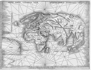
The modern world, by Martin Waldseemller (date uncertain)
Appendix
THE STEVENS-BROWN MAP
I hope to find time to write you shortly about a map I have discovered which bears the name America earlier than anything known, and somehow the idea has got into my mind that it is Waldseemllers long lost St. Di map.
Henry Newton Stevens Jr. to John Nicholas Brown (1896)
IN DECEMBER OF 1893, at a book auction in London, the American rare-book and map dealer Henry Newton Stevens Jr. bought an incomplete copy of the 1513 Strassburg Geography. The copy consisted of a fragment of Ptolemys text and just one map: Martin Waldseemllers well-known 1513 depiction of the modern world ( ). The offering attracted no other bidders, and Stevens was able to obtain it for the bargain price of two pounds, four shillings.
Stevens gave little thought to what he had bought. As one of the partners at Henry Stevens, Son & Stiles, an antiquarian bookseller located just across the street from the British Museum, he routinely scooped up cheap, imperfect copies of rare texts and then stored them away in his shop. If later he acquired a better but nevertheless incomplete copy of one of these texts, he could often extract pages from his fragmentary copies and use them to restore his better texts, so that he could sell them as complete.
Stevens didnt touch his Ptolemy fragment for a few years, until, in the mid-1890s, he had reason to dig it out of storagewith a view, he would later recall, to improving another imperfect copy which had just been acquired. But, to his astonishment, when he looked over the map this time he noticed something that he hadnt seen before: the word america, printed in block letters across the New World.
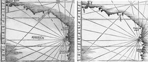
).
This was most strange. Many copies of Waldseemllers 1513 world map had survived into the nineteenth century, but all of themprinted as they were after Waldseemllers apparent retraction of the word Americaleft the New World nameless. In size, title, and general appearance, Stevenss map was almost identical to the 1513 map, but as he inspected it closely Stevens realized that it had been printed from an entirely different woodblock, and that it contained two important differences: it used inserted roman type for place-names, instead of carved Gothic letters, and it included a few place-names that didnt appear on the 1513 mapmost notably, America ( Figures 81 and 82 ).
The discovery thrilled Stevens. At the time, historians of cartography considered Peter Apians 1520 copy of Waldseemllers big 1507 map ( ) to be the earliest surviving printed map containing the name America. Stevens realized that his map might be several years earlier than Apians, and that perhaps what he had in his possession was a prototype of the 1513 map, engraved and printed sometime before April of 1507sometime, that is, before the Gymnasium had postponed work on its new edition of Ptolemy. Stevens even began to imagine that his map might be the long-lost 1507 map itself.
Stevens promptly sent news of his find to one of his most important customers, John Nicholas Brown, an avid American collector of books and maps relating to the discovery of the New World. Brown was the scion of the family that in the previous century had helped found Brown University, in Providence, Rhode Island, and his collection was (and still is) housed in the universitys rare-book library, the John Carter Brown Library. Please regard this as confidential at present, Stevens told Brown after suggesting to him that his map might be the Waldseemller map of 1507. It is not for sale yet, but you shall have first offer when it is.


