Martin Brückner - The Social Life of Maps in America, 1750-1860
Here you can read online Martin Brückner - The Social Life of Maps in America, 1750-1860 full text of the book (entire story) in english for free. Download pdf and epub, get meaning, cover and reviews about this ebook. year: 2017, publisher: Omohundro Institute and University of North Carolina Press, genre: Politics. Description of the work, (preface) as well as reviews are available. Best literature library LitArk.com created for fans of good reading and offers a wide selection of genres:
Romance novel
Science fiction
Adventure
Detective
Science
History
Home and family
Prose
Art
Politics
Computer
Non-fiction
Religion
Business
Children
Humor
Choose a favorite category and find really read worthwhile books. Enjoy immersion in the world of imagination, feel the emotions of the characters or learn something new for yourself, make an fascinating discovery.

- Book:The Social Life of Maps in America, 1750-1860
- Author:
- Publisher:Omohundro Institute and University of North Carolina Press
- Genre:
- Year:2017
- Rating:3 / 5
- Favourites:Add to favourites
- Your mark:
The Social Life of Maps in America, 1750-1860: summary, description and annotation
We offer to read an annotation, description, summary or preface (depends on what the author of the book "The Social Life of Maps in America, 1750-1860" wrote himself). If you haven't found the necessary information about the book — write in the comments, we will try to find it.
Martin Brückner: author's other books
Who wrote The Social Life of Maps in America, 1750-1860? Find out the surname, the name of the author of the book and a list of all author's works by series.


The Social Life of Maps in America, 1750-1860 — read online for free the complete book (whole text) full work
Below is the text of the book, divided by pages. System saving the place of the last page read, allows you to conveniently read the book "The Social Life of Maps in America, 1750-1860" online for free, without having to search again every time where you left off. Put a bookmark, and you can go to the page where you finished reading at any time.
Font size:
Interval:
Bookmark:
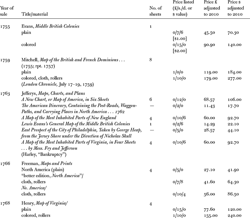
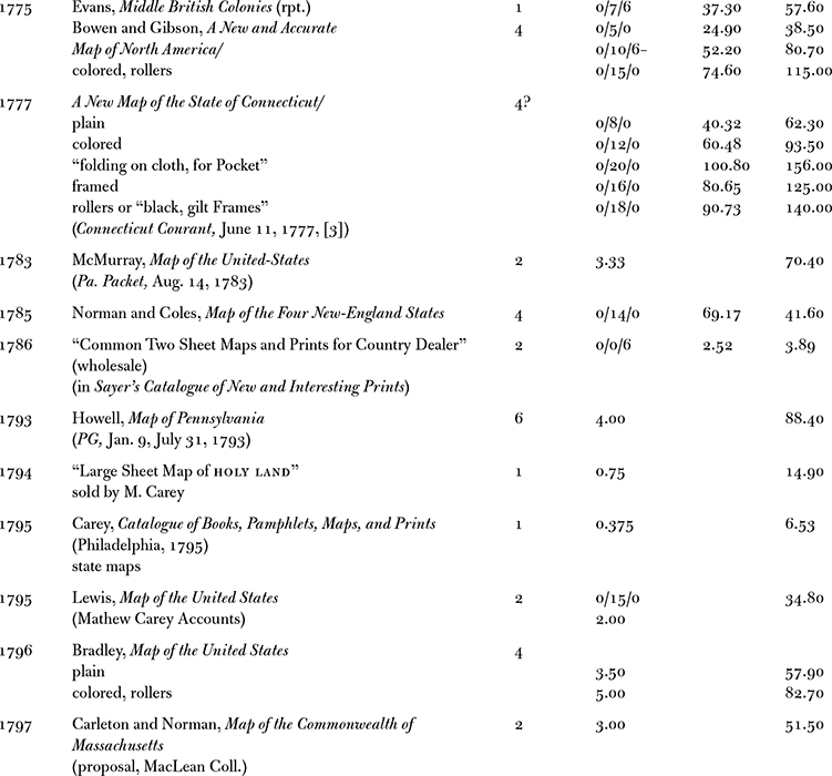
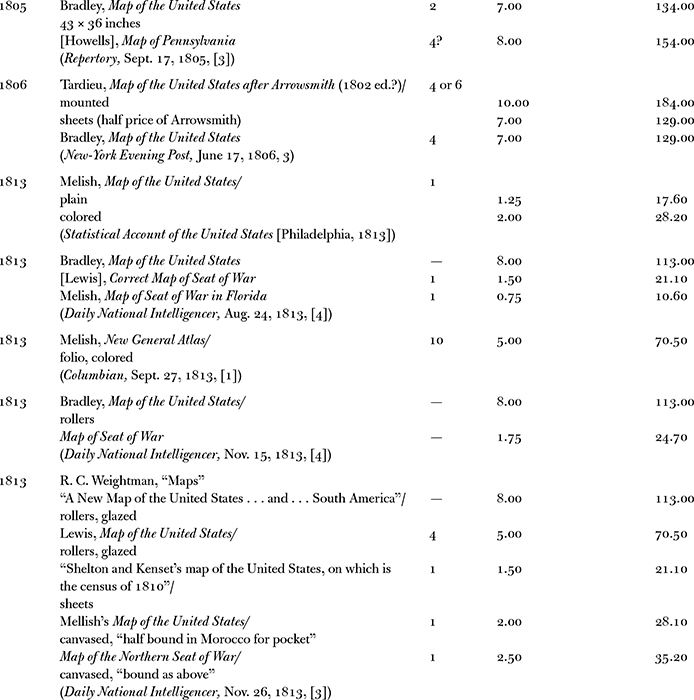

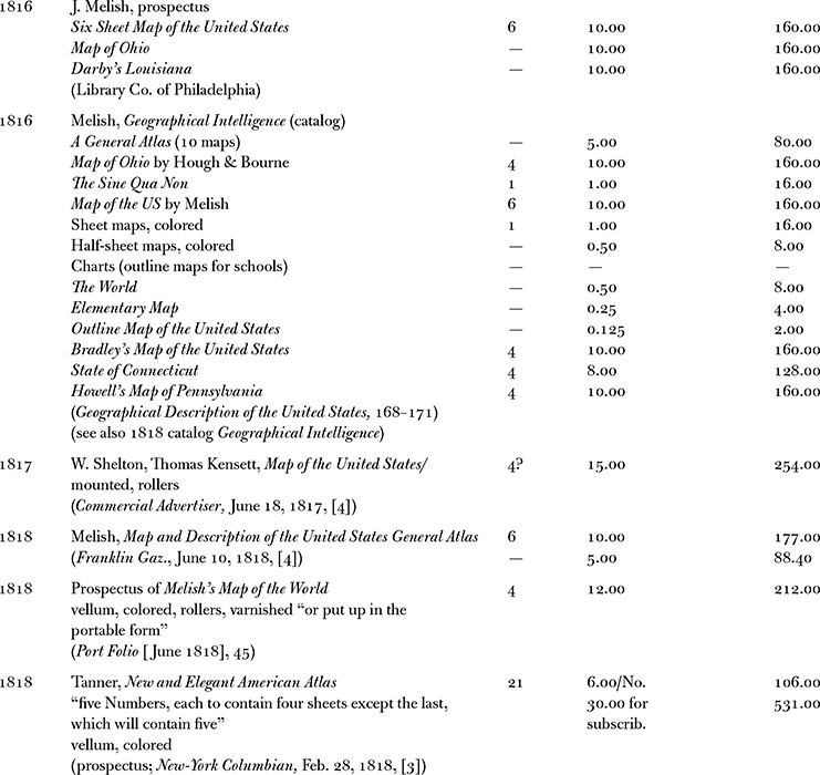
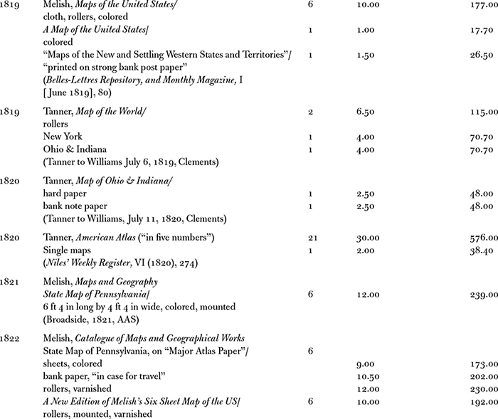
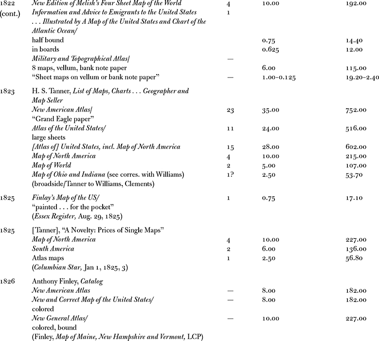
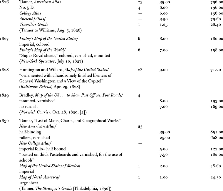
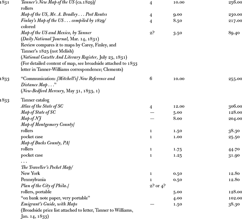
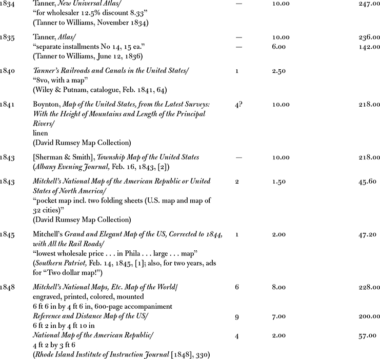

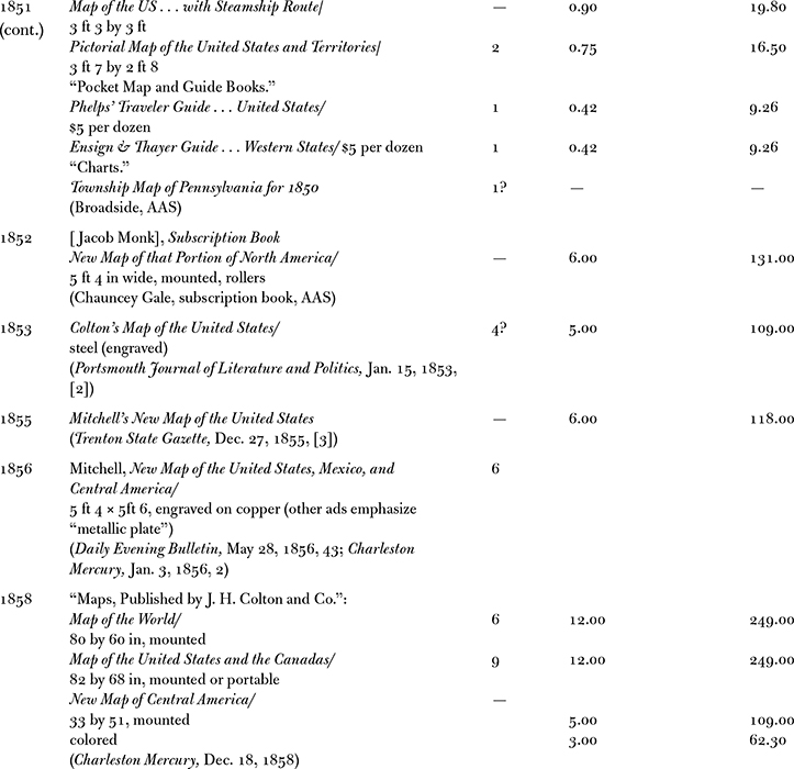
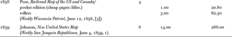
Sources: Throughout the book, original map prices have been adjusted to their 2010 values using the following sources: John J. McCusker, How Much Is That in Real Money? A Historical Commodity Price Index for Use as a Deflator of Money Values in the Economy of the United States (Worcester, Mass., 2001), 297373, and the online tools http://www.measuringworth.com/ppowerus/ and http://www.parliament.uk/commons/lib/research/rp2002/rp02-044.pdf. If not listed in Appendix, prices reflect source materials cataloged here in chronological order that reference maps advertised in commercial venues but not in personal or institutional inventories: John Bowles, A Catalogue of Maps, Prints, Copy-Books... (London, 1753); William Dicey and Cluer Dicey, A Catalogue of Maps, Prints, Copy-Books, Drawing-Books... (London, 1754); Lewis Evanss prices, Pennsylvania Gazette (Philadelphia), Nov. 27, 1755; Howells prices, ibid., Jan. 9, July 31, 1793; Maps, Charts, and Plans, Published for, and Sold by Thomas Jefferys (London, 1763); Philip Freeman, Boston, September 30, 1766; on Monday, the 13th of October Next, Will Be Offered to Sale at a Store in Union-Street, Opposite to the Corn-Field, a Valuable Collection of Books, a Variety of Maps and Prints... (Boston, 1766); Robert Sayers New and Enlarged Catalogue for the Year MDCCLXVI of New, Useful, and Correct Maps (London, 1766); Robert Bell, A Catalogue of New and Old Books... (Boston, 1770); Garrat Noel and [Ebenezar] Hazard, Catalogue of Books... (New York, 1771); William Faden and Thomas Jefferys, A Catalogue of Modern and Correct Maps, Plans, and Charts (London, 1774); Robert Sayer and John Bennett, Sayer and Bennetts Enlarged Catalogue of New and Valuable Prints, in Sets, or Single; Also Useful and Correct Maps and Charts... (London, 1775); Robert Bell, A Catalogue of a Large Collection of New and Old Books... (Philadelphia, 1783); William McMurrays Map of the United-States, advertised in Pennsylvania Packet; or, The General Advertiser (Philadelphia), Aug. 14, 1783; Robert Sayers Catalogue of New and Interesting Prints... (London, 1786); Mathew Carey, Catalogue of Books, Pamphlets, Maps, and Prints (Philadelphia, 1795); Mathew Carey Accounts, microfilm, roll 1, nos. 2176, 2340, 2396, 2817, Library Company of Philadelphia; Melish, Prospectus of a Six Sheet Map of the United States... (Philadelphia, 1816), and Geographical Intelligence: The Following Geographical Works Have Been Published by John Melish, and Are for Sale, at the Price Annexed ([Philadelphia], 1818); Melish, A Catalogue of Maps and Geographical Works, Published and for Sale... (Philadelphia, 1822). For select maps, see the records reproduced by J. B. Harley, The Bankruptcy of Thomas Jefferys: An Episode in the Economic History of Eighteenth Century Map-Making, Imago Mundi, XX (1966), 35; David Bosse, The Boston Map Trade of the Eighteenth Century, in Alex Krieger, David Cobb, and Amy Turner, eds., Mapping Boston (Cambridge, 1999), 3839; Bosse, Maps in the Marketplace: Cartographic Vendors and Their Customers in Eighteenth-Century America, Cartographica, XLII (2007), 916; and Mary Sponberg Pedley, The Commerce of Cartography: Making and Marketing Maps in Eighteenth-Century France and England (Chicago, 2005), app. 5.
In Statement of Losses Sustained by John Melish, and the Means whereby He Became Insolvent, Insolvency Petitions and Bonds, 17901868, folder Common Pleas CourtInsolvencyJohn Melish, Sept. 25, 1821, term no. 158, Philadelphia City Archive.
STORE[ROOM] FURNITURE
3 brass lamps and 1 Glass dt.
2 desks
1 Tin reflector
3 writing tables1 Drawing dt.
2 Compters
3 Cases Drawers
2 Desk Stools
3 boards and 5 presses
2 Stoves
1 pair andirons tongs etc
1 bench
the shelving in front and back stores
PRINTING DEPARTM.
3 printing presses and apparatuses
1 jug varnish
3 stoves
1 paint stone and muller
1 Senew[?] Press
12 press cloths
3 ink rollers
1 copper kettle
pots and boxes for lye, troughs, tables, boards etc
1 grind stone
BINDING DEPT.
2 standing presses and 1 small press
1 cutting press and plow
28 pressing boards
10 boards for mounting maps
50 lb paste board
50 sheep skin
12 quires marble paper
131 trullens[?] boards
30 covers for portable maps
24 skins blue morocco
Polisher, burnisher, sheers etc
VARNISHING DEPT
3 Demijohns contg 6 Gall copol[?] Varnish
90 frames for mounting maps
12 boards for dt
Presses and table
2 straight edges
Stove, varnishing brushes etc
PAINTING DEPT.
1 stove
5 tables
8 chairs
1 large press
1 bureau
1 small chest drawers
Saucers colours brushes etc
A) On first sight, perhaps the most noticeable pattern is that between 1750 and 1860 map prices were always in flux but trended into two different directions. Looking at the linear approximation cutting across all the data, we discover that, with the exception of one-sheet maps, all other material map types reflect an increase in their relative value over time; or, to put this more simply, on average, two-sheet and larger maps became more expensive for consumersseemingly contradicting the impact of mechanization and mass production. In particular, six-sheet maps, valued around $150 to $200 dollars today, appear to have retained their status as high-end commodities, categorizing them with decorative furnishings, like mirrors and pictures, rather than the products of print media and communication technology.
Font size:
Interval:
Bookmark:
Similar books «The Social Life of Maps in America, 1750-1860»
Look at similar books to The Social Life of Maps in America, 1750-1860. We have selected literature similar in name and meaning in the hope of providing readers with more options to find new, interesting, not yet read works.
Discussion, reviews of the book The Social Life of Maps in America, 1750-1860 and just readers' own opinions. Leave your comments, write what you think about the work, its meaning or the main characters. Specify what exactly you liked and what you didn't like, and why you think so.