PICTURING America
THE GOLDEN AGE OF PICTORIAL MAPS
Stephen J. Hornsby
THE UNIVERSITY OF CHICAGO PRESS
CHICAGO & LONDON

The University of Chicago Press, Chicago 60637
The University of Chicago Press, Ltd., London
2017 by Stephen J. Hornsby and The Library of Congress
All rights reserved. Published 2017.
Printed in China
26 25 24 23 22 21 20 19 18 17 1 2 3 4 5
ISBN -13: 978-0-226-38604-1 (cloth)
ISBN -13: 978-0-226-38618-8 (e-book)
DOI : 10.7208/chicago/9780226386188.001.0001
Library of Congress Cataloging-in-Publication Data
Names: Hornsby, Stephen J. (Stephen John), 1956 author. | Ehrenberg, Ralph E., 1937 writer of foreword. | Library of Congress. Geography and Map Division, contributor, publisher.
Title: Picturing America : the golden age of pictorial maps / Stephen J. Hornsby.
Description: Chicago ; London : The University of Chicago Press, in association with the Library of Congress, 2017. | Includes bibliographical references and index. | Shows maps of the United States of America and other geographical areas of the world. | Pictorial maps are artistic renderings rather than scientific representations of places that combine cartographic elements with texts and images and feature bold and arresting graphic design, bright and cheerful colors, and lively detail. In the United States, the 1920s through about 1970 represented a golden age for the form, which this book looks at and considers as a genreProvided by publisher.
Identifiers: LCCN 2016012939 | ISBN 9780226386041 (cloth : alk. paper) | ISBN 9780226386188 (e-book)
Subjects: LCSH : United StatesMaps. | Pictorial maps. | Pictorial mapsHistory20th century. | CartographyUnited StatesHistory20th century. | LCGFT : Atlases. | Pictorial maps.
Classification: LCC g1201.a5 h67 2017 | DDC 912.73dc23 lc record available at https://lccn.loc.gov
 This paper meets the requirements of ANSI/NISO z39.481992 (Permanence of Paper).
FOR Anne
CONTENTS
Maps and atlases have been an important part of the collections of the Library of Congress since its establishment in 1800 when a congressional committee purchased three maps and an atlas from a London dealer. From this modest beginning, the Librarys cartographic holdings have grown during the past two centuries to more than five million maps, atlases, globes, terrain models, and geospatial digital datasets.
The Librarys Geography and Map Division has custody of the bulk of these cartographic materials. Established in 1897 as the Hall of Maps to serve Congress and US government agencies, the Geography and Map Division functions as the National Map Library. Its primary responsibilities are developing and preserving the Librarys cartographic collections and making them available to Congress, government officials, scholars, and the general public through a research reference center and website. An average of forty thousand analogue and digital cartographic materials are acquired yearly through government deposits, transfers of superseded maps from US government libraries, copyright deposits, domestic and international exchanges, purchases, and donations. These range from rare maps and atlases to state-of-the-art electronic geospatial datasets in 150 languages. Some four hundred thousand cartographic materials have been cataloged, and their bibliographic records are available online. As a major service to the map library community, the division also establishes, maintains, and disseminates national standards for classifying and cataloging cartographic materials. More than fifty thousand maps and atlases, including many pictorial maps, have been electronically scanned and are available for viewing and downloading on the Librarys online website.
Sharing the Librarys rich geographic and cartographic collections with the scholarly community and the general public is another major objective of the Geography and Map Division. This is facilitated by working closely with the Librarys Publications Office to identify authors that provide innovative, novel, or original analysis of one or more of the divisions maps or collections.
Stephen J. Hornsby is one such author. I first met Dr. Hornsby when he inquired about one of our maps for his contemplated book on pictorial maps, a relatively unknown part of Western cartography. Pictorial maps have fascinated me since we acquired Muriel H. Parrys collection shortly after I first joined the division. As a map librarian at the Department of State, Ms. Parry often visited the Geography and Map Division. She would be delighted that her collection of pictorial maps provided one of the major sources for a renewed interest in this genre. Another librarian, Ethel M. Fair, who served as director of the Library School of the New Jersey College of Women for many years, assembled the divisions other major collection on which Dr. Hornsby relied. Each collection is extensive, numbering more than eight hundred maps.
The United States contributed massively to the development of pictorial mapping, spurred by the nations burgeoning economy and dynamic popular culture from the 1920s to the 1950s that was characterized by unprecedented social changes, technological advances, and innovations in architecture, film, literature, music, and the visual arts. Striking and colorful, pictorial maps were widely used as a form of commercial advertising during that era and they formed a familiar part of the world in which Fair and Parry were raised and matured. Because contemporary curators and librarians generally did not consider pictorial maps geographic or scientific, most libraries did not collect them and they are quite rare today. The Geography and Map Division was an exception. Many pictorial maps in addition to those found in the Fair and Parry collections are held by the division as a result of the US copyright law that requires publishers to deposit two copies of each map they submit for copyright protection to the Library of Congress.
Drawing principally upon the Fair and Parry collections, as well as other public and private collections, Dr. Hornsbys book reveals for the first time how American pictorial mapping exploded on the early twentieth-century scene and how it developed over time. He introduces a new generation to some of the principal cartographic artists who made pictorial maps a uniquely American art form. His categories of different kinds of pictorial maps help us to understand how diverse this genre was and how far it reached in American life.
This book is a contribution to our understanding of the history of twentieth-century cartography and the special role that American popular mapping played in that history. It will also introduce to a wider public the extraordinary riches of a previously virtually unknown part of the Geography and Map Collection at the Library of Congress.
RALPH E. EHRENBERG
Chief, Geography and Map Division
Library of Congress
An American Genre
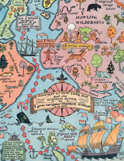
From the 1920s to the 1960s, American popular culture and commercial mapmaking intersected to produce a remarkably creative period in the history of Western cartography. During those years, dozens of graphic artists and cartographers created thousands of pictorial maps depicting the history, geography, and culture of the United States and lands overseas. No other country produced the quantity, quality, and variety of pictorial maps that the United States did. Although now little known, pictorial maps were enormously popular during their heyday, decorating homes, schools, and clubs; appearing in books, magazines, and newspapers; and circulating as tourist guides and advertising brochures. The maps reflected American culture, capturing the dynamism of the nations burgeoning skyscraper cities, great industrial factories, and streamlined locomotives, airplanes, and automobiles, as well as portraying the countrys fascination with its colonial and early Republican past. Pictorial maps also displayed advances in printing technology, particularly color lithography, and showcased the talents and originality of some of the nations leading graphic artists. By World War II, pictorial maps had created a powerful visual image of the United States and were beginning to reimagine the look of the world for a mass consumer audience.





 This paper meets the requirements of ANSI/NISO z39.481992 (Permanence of Paper).