Mitchell Rose. - Maps - Their Untold Stories
Here you can read online Mitchell Rose. - Maps - Their Untold Stories full text of the book (entire story) in english for free. Download pdf and epub, get meaning, cover and reviews about this ebook. genre: Science / History. Description of the work, (preface) as well as reviews are available. Best literature library LitArk.com created for fans of good reading and offers a wide selection of genres:
Romance novel
Science fiction
Adventure
Detective
Science
History
Home and family
Prose
Art
Politics
Computer
Non-fiction
Religion
Business
Children
Humor
Choose a favorite category and find really read worthwhile books. Enjoy immersion in the world of imagination, feel the emotions of the characters or learn something new for yourself, make an fascinating discovery.

- Book:Maps - Their Untold Stories
- Author:
- Genre:
- Rating:4 / 5
- Favourites:Add to favourites
- Your mark:
Maps - Their Untold Stories: summary, description and annotation
We offer to read an annotation, description, summary or preface (depends on what the author of the book "Maps - Their Untold Stories" wrote himself). If you haven't found the necessary information about the book — write in the comments, we will try to find it.
Mitchell Rose.: author's other books
Who wrote Maps - Their Untold Stories? Find out the surname, the name of the author of the book and a list of all author's works by series.


Maps - Their Untold Stories — read online for free the complete book (whole text) full work
Below is the text of the book, divided by pages. System saving the place of the last page read, allows you to conveniently read the book "Maps - Their Untold Stories" online for free, without having to search again every time where you left off. Put a bookmark, and you can go to the page where you finished reading at any time.
Font size:
Interval:
Bookmark:

This electronic edition published in 2014 by Bloomsbury Publishing Plc
Published 2014 by Bloomsbury Publishing Plc,
50 Bedford Square, London WC1B 3DP
www.bloomsbury.com
Bloomsbury is a trademark of Bloomsbury Publishing Plc
The National Archives logo Crown Copyright 2014
The National Archives logo device is a trade mark of The National Archives and is used under licence.
Text and maps Crown Copyright 2014
The right of Rose Mitchell and Andrew Janes to be identified as the authors of this work has been asserted by them in accordance with the Copyright, Designs and Patents Act 1988.
ISBN 978-1408-1-8967-2
All rights reserved You may not copy, distribute, transmit, reproduce or otherwise make available this publication (or any part of it) in any form, or by any means (including without limitation electronic, digital, optical, mechanical, photocopying, printing, recording or otherwise), without the prior written permission of the publisher. Any person who does any unauthorised act in relation to this publication may be liable to criminal prosecution and civil claims for damages.
This book is produced using paper that is made from wood grown in managed sustainable forests. It is natural, renewable and recyclable. The logging and manufacturing processes conform to the environmental regulations of the country of origin.
To find out more about our authors and their books please visit www.bloomsbury.com where you will find extracts, author interviews and details of forthcoming events, and to be the first to hear about latest releases and special offers, sign up for our newsletters here.
PREFACE
MAPS OUT OF THE ARCHIVES
Our aim in writing this book was to share more widely some of the remarkable maps here at The National Archives, and also to relate some of the fascinating tales that lie behind them. We have selected 100 maps from among the many possibilities, with a broad range of dates, places and contexts. These maps are not a representative sample but chosen to convey something of the diversity of maps in the archives. We have arranged them into eight themed chapters, although many of our choices could have fitted more than one theme and there are many overlaps in subject matter between maps in different chapters.
We have then placed the maps in their historical and documentary context, as part of the official government archives of the United Kingdom. However, this is to some extent our personal view of them, and we hope that you will perceive some of them differently from us. Above all, we hope that you will enjoy looking at and reading about our maps as much as we have enjoyed writing about them.
Rose Mitchell and Andrew Janes
Map archivists
Kew, London, April 2014
For further information about maps in The National Archives, please visit www.nationalarchives.gov.uk/maps
Contents
CHAPTER ONE
EARLY MAPS
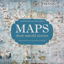
Maps from earlier times are different from the kind of maps we are familiar with today. In this chapter we explore a selection that illustrates the diversity of maps from the 15th century to the 17th century, and some of the reasons why they were made. Most of these maps were manuscript, drawn before more standardised printed maps became common. They are of ten colourful and provide highly individual views of places, buildings, plant life and coastlines, before the genre of British landscape painting had begun. Sometimes mapmakers tried to show hypothetical places such as a posited southern continent of the same size as the Arctic, and the map even shows the outer edges of the heavens.
Maps gradually became accepted as a useful and attractive way to present viewpoints, knowledge and information. The oldest maps in the archives date from the 14th century, but maps were relatively rare until the 16th century. The archives holds seven maps and one chart dated before 1500. Two of these maps are included in this chapter, showing medieval landscapes in Surrey and Yorkshire. The number of maps produced increases to about 75 for 1500 1550, doubled for 1550 1580, and with perhaps 200 further maps for 1580 1600 when mapmaking became more widespread.
Why did people start making and using maps? From the early 16th century maps began to be increasingly appreciated and used for diplomacy, defence and government administration. Map use in law courts was encouraged after a map affected the verdict in a case in 1515. Influential individuals such as the statesman Lord Burghley saw the importance of maps and helped to make them common currency at the court of Elizabeth I. The visual nature of maps was especially helpful in conveying information about far-off places, when planning military campaigns abroad, colonising, and for an over view of foreign states, especially those which were likely to be a threat to England. See, for instance, the French administrative map , used for military intelligence.
Early maps were usually made for a specific purpose, by hand, when needed. They dealt with a particular issue where multiple copies were not required, or with secret matters such as defence where they were for the eyes of the ruling elite alone. What is shown is selective, chosen to reflect a maps purpose. The Knaresborough Castle plan () could show more of the nearby palace. Maps drawn for opposing par ties in a legal case may show very different views of the same land. This limited focus on the matter in hand resulted in maps of small places such as remote moorlands but fewer of towns, regions or the whole country.
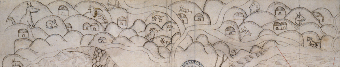
WOLVES, RABBITS AND WILD MEN: A scene in the hills above Portrush peninsula, County Antrim, Ireland in 1580.
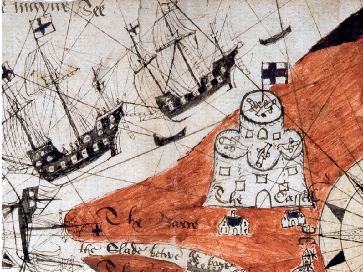
CASTLE IN THE SAND: Camber Castle near Rye, Sussex (see ).
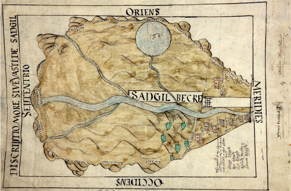
LAKELAND FELLS: Dynamic depiction of hills surrounding the river valley and hamlet of Sadgill, Westmorland, drawn for a court case in 1578.
The success of early maps was measured by the extent to which they achieved their purpose, rather than their accuracy in the modern sense. They may not be drawn to scale, and the mapmaker might even emphasise important features by portraying them disproportionately larger than their true size. Some maps are rough sketches, others in pictorial style. They might be drawn to make best use of the piece of parchment or paper and so north may not be at the top. We may need to look at related documents to interpret a map, to tell us who made it, when, why, and what happened to it next, questions which early maps of ten do not answer in themselves.
If reading early maps requires skill and a fresh mind, it also offers us a window on the world of centuries past. It can be fascinating to glimpse lost palaces and castles, long-fallen ancient crosses and deserted villages, in a landscape of ten vastly changed from the one we see now. Until the last quarter of the 16th century mapmaking was an activity to which any educated man might turn his hand, with no particular training in cartography but a knowledge of the place that he drew. Mapmakers used their creativity to express the point of the map, and added embellishments in the form of animals, monsters and ships. Their maps were made in a profusion of styles, shapes and colours.
Font size:
Interval:
Bookmark:
Similar books «Maps - Their Untold Stories»
Look at similar books to Maps - Their Untold Stories. We have selected literature similar in name and meaning in the hope of providing readers with more options to find new, interesting, not yet read works.
Discussion, reviews of the book Maps - Their Untold Stories and just readers' own opinions. Leave your comments, write what you think about the work, its meaning or the main characters. Specify what exactly you liked and what you didn't like, and why you think so.