BATTLEFIELD
YORKSHIRE
BATTLEFIELD
YORKSHIRE
FROM THE ROMANS TO THE
ENGLISH CIVIL WARS
David Cooke
First published in Great Britain in 2006 by
Pen & Sword Military
an imprint of
Pen & Sword Books Ltd
47 Church Street
Barnsley
South Yorkshire
S70 2AS
Copyright David Cooke, 2006
ISBN 1 84415 424 6
The right of David Cooke to be identified as Author of this Work has been asserted by him in
accordance with the Copyright, Designs and Patents Act 1988.
A CIP catalogue record for this book is available from the British Library.
All rights reserved. No part of this book may be reproduced or transmitted in any form or by any
means, electronic or mechanical including photocopying, recording or by any information storage and
retrieval system, without permission from the Publisher in writing.
Typeset in Palatino by
Phoenix Typesetting, Auldgirth, Dumfriesshire
Printed and bound in England by
Biddies Ltd, Kings Lynn
Pen & Sword Books Ltd incorporates the Imprints of Pen & Sword Aviation, Pen & Sword Maritime,
Pen & Sword Military, Wharncliffe Books,
Pen & Sword Select, Pen & Sword Military Classics and Leo Cooper.
For a complete list of Pen & Sword titles please contact
PEN & SWORD BOOKS LIMITED
47 Church Street, Barnsley, South Yorkshire, S70 2AS, England
E-mail: enquiries@pen-and-sword.co.uk
Website: www.pen-and-sword.co.uk
CONTENTS
In AD 71 the Romans established a garrison fortress for the IXth Legion on the banks of a river, now called the Ouse, in the heart of Brigantian territory. The Brigantes had been a client state of Rome but after a short-lived revolt against their queen, Cartimandua, led by her ex-husband, Venutius, the Romans had stepped in and assumed control of the area. The fortress was built on the north bank of the Ouse, while a civilian settlement grew on the south bank. Over the centuries the name, and function, of the site changed, from Eboracum, to Jorvik, to York, and the fortress became a city and gave its name to the surrounding area Yorkshire.
York was born from a military campaign and since then has had a rich military history. The county can claim the largest battle on English soil, although there is still disagreement as to whether it is Towton or Marston Moor. Towton was the bloodiest battle, with 28,000 casualties reported by the chroniclers of the time, although this is almost certainly a vastly inflated figure. Marston Moor was the largest battle of the English Civil Wars, and had the highest casualty figures, with over 4,000 dead being buried by the local population in the days following the battle a much more reliable figure than that for Towton.
The county has been the site of civil wars, foreign invasions and dynastical struggles. It has also seen many of the foremost fighting men of their periods taking part in life-or-death struggles. Penda, king of Mercia, Harald Hardrada, king of Norway, Warwick the Kingmaker, Black Tom Fairfax, Oliver Cromwell and Prince Rupert of the Rhine, to name but a few, all took part in battles within the county, and two of them lost their lives.
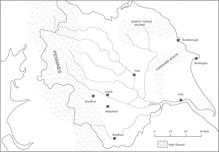
The topography of the county had a major effect on where battles were fought. You only have to look at a relief map of Yorkshire to see that both the east and west sides of the county are constrained by high ground, which was very unsuitable for armies to operate. To the west are the Pennines, and in the north of the county the Yorkshire Dales, while to the east are the Wolds and North Yorkshire Moors. Along the north-south belt of low ground ran the Great North Road, now replaced by the A1, and it was along this road that armies moved into the county from the north and south. Another method of entry was along the River Ouse and this was used on a number of occasions by sea-borne raiders and invaders, such as the Vikings.
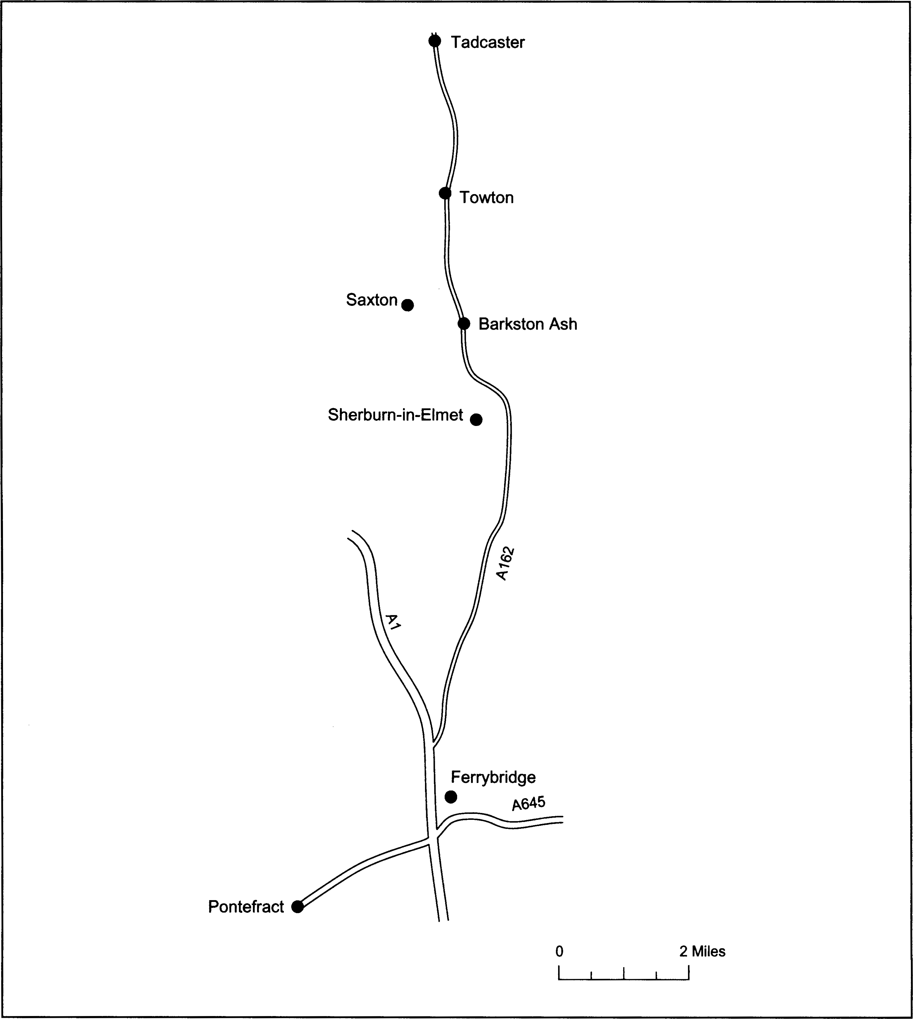
Many of the battles fought within the county fall within this belt of low-lying ground, although there are exceptions. Let me give you an example, by taking a short car ride from Pontefract to Tadcaster along the A162, which closely follows the course of the old Great North Road. Pontefract has a rich military history. In 1460 the Lancastrian army left Pontefract to attack Richard, Duke of York, at his castle at Sandal near Wakefield. This led to the Battle of Wakefield in which the Yorkist army was routed and the Duke of York and his son were killed. Pontefract Castle was besieged several times during the Civil Wars and a mounted action was fought within sight of the castle in 1645 when a force of Royalist cavalry successfully resupplied the beleaguered garrison.
Now move on a few miles to Ferrybridge. This was the scene of two small actions during the Wars of the Roses and the English Civil Wars. After a few more miles we come to Sherburn-in-Elmet. Once again this was the site of two actions, both during the First Civil War. The first was a cavalry raid led by Sir Thomas Fairfax. The second was a battle of two halves. A large body of Royalist cavalry defeated the garrison during the morning then was surprised and routed by a pursuing body of Parliamentary horse in the afternoon.
The next place of interest along the road is Barkston Ash. Following the action at Ferrybridge in 1461, Lord Clifford led his men back towards the main Lancastrian army camped at Towton, hotly pursued by the Yorkist army. He turned to face his pursuers at a place called Dintingdale where his force was overwhelmed and Clifford killed. There is disagreement as to where Dintingdale actually was, as the name is no longer in use. One possible site is Barkston Ash. A second possible site is a short distance along the road where a minor road to Saxton leaves the A162.
Continuing along the main road you will notice a ridge line on the left-hand side, running at right angles to the road, with a lone tree close to its eastern end. This is the ridge along which the Yorkist army deployed at the Battle of Towton, and the Duke of Norfolk marched his force along the same road as you are driving on, to reinforce King Edward and win the day. Between the ridge and the next village, Towton, is the battlefield. As you pass the junction on the left as you enter the village, which leads onto the battlefield, you pass a gateway, which is the entrance to Towton Hall. This was the site of an archaeological dig of a battle grave pit.
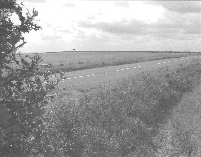
Looking south from the Towton battlefield towards Ferrybridge. The A162 runs to the left of the lone tree on the ridge and Ferrybridge power station can be seen on the horizon at the right-hand side of the illustration. Between these two points numerous military actions have taken place.
Further on through the village, on the left-hand side, is the Rockingham Arms. Just beyond it is a small lane which drops down the hill to the Cock Beck. This is where the modern road and the Great North Road part company for a short distance. The old road followed the course of this track down to the river, which it crossed on a narrow bridge, before it followed the valley towards Tadcaster. A bridge still exists today, and remnants of an older bridges stone footings can be seen at the side of it. A few years ago I was taking part in a walk around the battlefield. The guide was recounting the story of how the river could be crossed at this point on a bridge of bodies in the aftermath of the Battle of Towton, when it suddenly struck me how many fighting men, and their leaders, must have tramped down the hill and crossed the various bridges that have existed on the site, as they marched towards York. King Harold Godwinsson crossed the bridge as he led his army on its march to Stamford Bridge in September 1066, and recrossed it as he returned south to face Duke William of Normandy at Hastings. The Lancastrian army would have crossed the bridge before the Battle of Towton (1461), and the Yorkist army, including King Edward IV and Warwick the Kingmaker, would have crossed after their victory, as they marched to York. Sir Thomas Fairfax also used this route to attack Tadcaster in the build up to his worst defeat, at Seacroft Moor in 1643. Thousands of men who passed this way died in the subsequent actions and never returned home. It is a moving thought.

